Category:Maps by Heinrich Scherer
Jump to navigation
Jump to search
Media in category "Maps by Heinrich Scherer"
The following 15 files are in this category, out of 15 total.
-
 1700 chart showing Subterranean Volcanoes & Other Phenomenons.jpg 9,193 × 6,169; 8.75 MB
-

-
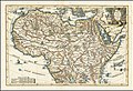 Africa Pars Borealis 1699.jpg 9,190 × 6,246; 12.69 MB
-
 Basic cartouche in the 1702 circumsailing world map by Scherer (1).jpg 1,604 × 2,235; 1,005 KB
-
 Basic cartouche in the 1702 circumsailing world map by Scherer (2).jpg 749 × 1,759; 423 KB
-
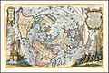
 Cumnecdum Stella Haec extorts suiset Olympo.jpg 5,111 × 6,238; 6.86 MB
-
 Figurative cartouche on an Africa map by Scherer.jpg 1,518 × 1,303; 614 KB
-
-
 Navigationes Praecipuae Europaeorum ad Exteras Nationes.jpg 2,500 × 1,636; 1.22 MB
-
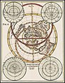 Proietio Optica Hemisphaerii Polaris Arctici.jpg 4,601 × 5,899; 5.04 MB
-
-
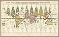
 Repraesentatio Orbis Terraquei Catholica, 1700.jpg 2,600 × 1,738; 2.17 MB
-
 Scherer - Austria, Stiria, Carinthia, Carniola (1699)-1.jpg 4,169 × 2,740; 3.27 MB
-
 Scherer - Austria, Stiria, Carinthia, Carniola (1699)-2.jpg 4,172 × 2,752; 3.3 MB
-


.jpg)
.jpg)


-1.jpg)
-2.jpg)
