Category:Maps about the COVID-19 pandemic in Costa Rica
Jump to navigation
Jump to search
Countries of North America: Canada · Costa Rica · Dominican Republic · El Salvador · Guatemala · Haiti · Honduras · Mexico · Panama · Trinidad and Tobago‡ · United States of America‡
‡: partly located in North America
‡: partly located in North America
Media in category "Maps about the COVID-19 pandemic in Costa Rica"
The following 9 files are in this category, out of 9 total.
-
 Cantones vacunación.jpg 1,280 × 1,280; 114 KB
-
 COVID-19 Outbreak Cases in Costa Rica by cantons (Density).png 1,600 × 1,600; 78 KB
-
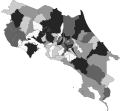
 COVID-19 Outbreak Cases in Costa Rica by cantons totals.svg 306 × 284; 159 KB
-
 COVID-19 Outbreak Cases in Costa Rica by cantons.png 1,600 × 1,600; 78 KB
-
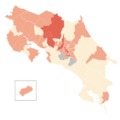
 COVID-19 Outbreak Cases in Costa Rica.png 1,600 × 1,600; 57 KB
-
 COVID-19 Outbreak Cases in Costa Rica.svg 764 × 696; 86 KB
-
 COVID-19 outbreak Costa Rica per capita cases map.svg 306 × 284; 159 KB
-
 COVID-19 Outbreak Deaths in Costa Rica by canton.svg 306 × 284; 159 KB
-
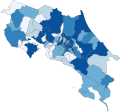 COVID-19 Vaccination map of Costa Rica by cantons totals.svg 306 × 284; 159 KB

.png)


