Category:Map of Ghent with levels, 1912
Jump to navigation
Jump to search
Media in category "Map of Ghent with levels, 1912"
The following 6 files are in this category, out of 6 total.
-
 Plattegrond-van-gent-met-peilen.jpg 744 × 429; 280 KB
-
 Elizabethbegijnhof, Detail from Map of Ghent by Compijn en Soenen.jpg 960 × 1,409; 591 KB
-
 Detail from Map of Ghent by Compijn en Soenen.jpg 960 × 1,409; 585 KB
-
 Detail, Plattegrond van Gent met peilen, 1912.png 770 × 501; 913 KB
-
 Ghent, 1912 poster.jpg 1,967 × 1,137; 1.17 MB
-
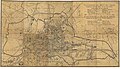
 Map of Ghent with levels, 1912.jpg 1,600 × 904; 417 KB


