Category:Manor in Przyszowice
Jump to navigation
Jump to search
| Object location | | View all coordinates using: OpenStreetMap |
|---|
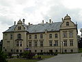
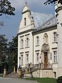
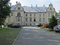
Polski: Przyszowice, ul. Gierałtowicka - park krajobrazowy i dwór, z końca XIX w.
Media in category "Manor in Przyszowice"
The following 12 files are in this category, out of 12 total.
-
 Przyszowice, pałac, widok od pd..JPG 4,000 × 3,000; 2.73 MB
-
 Herb v. Ludwig.jpg 800 × 1,100; 277 KB
-
 Herb von Ludwig.jpg 274 × 346; 29 KB
-
 Przyszowice - pałac 2.JPG 3,072 × 2,304; 1.9 MB
-
 Przyszowice - pałac.JPG 1,600 × 1,200; 681 KB
-
 Przyszowice pałac.jpg 5,564 × 3,708; 13.15 MB
-
 Przyszowice, pałac, fragment elewacji południowej.JPG 3,000 × 4,000; 2.82 MB
-
 Przyszowice, pałac, herb nad wejściem.JPG 4,000 × 3,000; 2.8 MB
-
 Przyszowice, pałac, wejście główne.JPG 3,000 × 4,000; 2.63 MB
-
 Przyszowice, pałac, widok od pd-wsch. (1).JPG 4,000 × 3,000; 3.08 MB
-
 Przyszowice, pałac, widok od pd-wsch. (2).JPG 3,000 × 4,000; 3.21 MB
-
 Przyszowice, pałac, widok od pn..JPG 4,000 × 3,000; 2.44 MB


.JPG)
.JPG)
