Category:Manor, Jegorova 10, Opatová, Lučenec
Jump to navigation
Jump to search
| Object location | | View all coordinates using: OpenStreetMap |
|---|
| This category shows the protected monument with the number 606-471/1 (other) in the Slovak Republic. |
| This category shows the protected monument with the number 606-471/2 (other) in the Slovak Republic. |
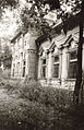
Slovenčina: Kaštieľ na Jegorovej ulici 10 v Lučenci, miestna časť Opatová
Media in category "Manor, Jegorova 10, Opatová, Lučenec"
The following 23 files are in this category, out of 23 total.
-
 Lučenec (časť Opatová) - Kaštieľ - Jegorova 10 - (1).jpg 550 × 330; 47 KB
-
 Lučenec (časť Opatová) - Kaštieľ - Jegorova 10 - (2).jpg 550 × 330; 63 KB
-
 Lučenec (časť Opatová) - Kaštieľ - Jegorova 10 - (3).jpg 356 × 550; 81 KB
-
 Lučenec (časť Opatová) - Kaštieľ - Jegorova 10 - (4).jpg 356 × 550; 67 KB
-
 Lučenec (časť Opatová) - Kaštieľ - Jegorova 10 - (5).jpg 356 × 550; 65 KB
-
 Lučenec (časť Opatová) - Kaštieľ - Jegorova 10.jpg 550 × 330; 41 KB
-
 Lučenec - ruiny kaštieľa v Opatovej -1.jpg 4,608 × 3,072; 3.62 MB
-
 Lučenec - ruiny kaštieľa v Opatovej -10.jpg 3,072 × 4,608; 3.27 MB
-
 Lučenec - ruiny kaštieľa v Opatovej -11.jpg 4,608 × 3,072; 3.55 MB
-
 Lučenec - ruiny kaštieľa v Opatovej -12.jpg 4,608 × 3,072; 3.69 MB
-
 Lučenec - ruiny kaštieľa v Opatovej -13.jpg 4,608 × 3,072; 3.62 MB
-
 Lučenec - ruiny kaštieľa v Opatovej -14.jpg 4,608 × 3,072; 3.55 MB
-
 Lučenec - ruiny kaštieľa v Opatovej -2.jpg 4,302 × 2,853; 2.61 MB
-
 Lučenec - ruiny kaštieľa v Opatovej -3.jpg 4,347 × 2,921; 2.96 MB
-
 Lučenec - ruiny kaštieľa v Opatovej -4.jpg 4,407 × 2,992; 2.71 MB
-
 Lučenec - ruiny kaštieľa v Opatovej -5.jpg 4,608 × 3,072; 3.6 MB
-
 Lučenec - ruiny kaštieľa v Opatovej -6.jpg 4,608 × 3,072; 3.34 MB
-
 Lučenec - ruiny kaštieľa v Opatovej -7.jpg 4,608 × 3,072; 3.23 MB
-
 Lučenec - ruiny kaštieľa v Opatovej -8.jpg 4,608 × 3,072; 3.27 MB
-
 Lučenec - ruiny kaštieľa v Opatovej -9.jpg 4,608 × 3,072; 3.59 MB
-
 Opatová (Lučenec) -1.jpg 4,005 × 2,946; 5.07 MB
-
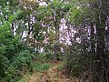 Pozostatky parku - Opatová.jpg 3,472 × 2,604; 2.09 MB
-
 Ruiny kaštieľa v Opatovej.jpg 3,472 × 2,604; 1.98 MB
_-_Ka%C5%A1tie%C4%BE_-_Jegorova_10_-_(1).jpg)
_-_Ka%C5%A1tie%C4%BE_-_Jegorova_10_-_(2).jpg)
_-_Ka%C5%A1tie%C4%BE_-_Jegorova_10_-_(3).jpg)
_-_Ka%C5%A1tie%C4%BE_-_Jegorova_10_-_(4).jpg)
_-_Ka%C5%A1tie%C4%BE_-_Jegorova_10_-_(5).jpg)
_-_Ka%C5%A1tie%C4%BE_-_Jegorova_10.jpg)


_-1.jpg)

