Category:Manoir de Gollodic
Jump to navigation
Jump to search
| Object location | | View all coordinates using: OpenStreetMap |
|---|
|
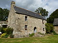
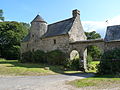
This building is inscrit au titre des monuments historiques de la France. It is indexed in the base Mérimée, a database of architectural heritage maintained by the French Ministry of Culture, under the reference PA00089294
|
human settlement in France  | |||||
| Upload media | |||||
| Instance of |
| ||||
|---|---|---|---|---|---|
| Location | Lanrivain, canton of Saint-Nicolas-du-Pélem | ||||
| Heritage designation |
| ||||
| Significant event |
| ||||
 | |||||
Media in category "Manoir de Gollodic"
The following 4 files are in this category, out of 4 total.
-
 Manoir de Gollodic à Lanrivain, balustrade et manoir.jpg 4,000 × 3,000; 6.72 MB
-
 Manoir de Gollodic à Lanrivain, côté cours.jpg 4,000 × 3,000; 6.64 MB
-
 Manoir de Gollodic à Lanrivain, détail balustrade.JPG 3,000 × 4,000; 6.93 MB
-
 Manoir de Gollodic à Lanrivain.jpg 4,000 × 3,000; 6.66 MB


