Category:Manoir d'Argentelles
Jump to navigation
Jump to search
| Object location | | View all coordinates using: OpenStreetMap |
|---|
|
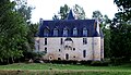
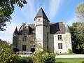
This building is en partie classé, en partie inscrit au titre des monuments historiques de la France. It is indexed in the base Mérimée, a database of architectural heritage maintained by the French Ministry of Culture, under the reference PA00110967
|
 Vue méridionale. | |||||
| Upload media | |||||
| Instance of | |||||
|---|---|---|---|---|---|
| Location | |||||
| Heritage designation |
| ||||
| Inception |
| ||||
 | |||||
Media in category "Manoir d'Argentelles"
The following 2 files are in this category, out of 2 total.
-
 FranceNormandieVillebadinArgentellesManoir.jpg 3,954 × 2,271; 5.82 MB
-
 Manoir d'Argentelles Villebadin.JPG 4,288 × 3,216; 5.32 MB
