Category:Mangotsfield
Jump to navigation
Jump to search
village in Gloucestershire, England .jpg) | |||||
| Upload media | |||||
| Instance of |
| ||||
|---|---|---|---|---|---|
| Location |
| ||||
 | |||||
English: Mangotsfield is a village in South Gloucestershire, England, situated north of the suburb of Kingswood, bounded to the north by the M4 motorway and to the east by the Emersons Green housing estate.
Subcategories
This category has the following 6 subcategories, out of 6 total.
Media in category "Mangotsfield"
The following 39 files are in this category, out of 39 total.
-
 2011 , B4465 Cossham Street, Mangotsfield - geograph.org.uk - 2586396.jpg 3,365 × 2,664; 3.42 MB
-
 2011 , B4465 Mangotsfield Road, Mangotsfield - geograph.org.uk - 2608673.jpg 3,139 × 3,033; 2.45 MB
-

-
 A sad spot for a family - geograph.org.uk - 140638.jpg 640 × 480; 150 KB
-
 A4174 at Shortwood - geograph.org.uk - 1313474.jpg 640 × 480; 218 KB
-
 Burley Grove - geograph.org.uk - 174292.jpg 480 × 640; 62 KB
-
 Carson's Chocolate Factory 1928 (34442306006).jpg 957 × 960; 290 KB
-
 Church for sale - geograph.org.uk - 3425198.jpg 640 × 480; 94 KB
-
 Cycle Path in Vinny Green - geograph.org.uk - 174262.jpg 480 × 640; 107 KB
-
 Emersons Green Lane - geograph.org.uk - 174590.jpg 480 × 640; 137 KB
-
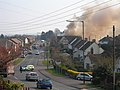 Huntsman Pub Fire - geograph.org.uk - 428481.jpg 640 × 480; 145 KB
-
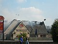 Huntsman Pub Fire - geograph.org.uk - 428483.jpg 640 × 480; 115 KB
-
 Looking along Burley Grove - geograph.org.uk - 174298.jpg 479 × 640; 110 KB
-
 M4 looking East from footbridge - geograph.org.uk - 140630.jpg 640 × 480; 128 KB
-
 Mangotsfield Common & Lamb Inn. - panoramio.jpg 2,444 × 1,613; 1.02 MB
-
 Mangotsfield dramway tunnel (2019).JPG 1,366 × 910; 736 KB
-
 Mangotsfield, Lamb Inn - geograph.org.uk - 2141126.jpg 1,024 × 768; 111 KB
-
 Path on the railway trackbed - geograph.org.uk - 1313490.jpg 640 × 480; 248 KB
-
 Path on the railway trackbed 2 - geograph.org.uk - 1313523.jpg 640 × 480; 245 KB
-
 Rodway Hill Manor House. - panoramio.jpg 2,394 × 1,795; 1.16 MB
-
 Stile on Rodway Road - geograph.org.uk - 174288.jpg 480 × 640; 114 KB
-
 The Langley Arms - geograph.org.uk - 591159.jpg 640 × 456; 80 KB
-
 The Owl and the Pussy Cat - geograph.org.uk - 174265.jpg 480 × 640; 118 KB
-
 Mangotsfield United Reformed Church - geograph.org.uk - 174648.jpg 480 × 640; 104 KB
-
 War Memorial, Mangotsfield. - panoramio.jpg 2,083 × 2,670; 2.05 MB
-
 Can you spot the speed camera^ - geograph.org.uk - 140636.jpg 640 × 480; 130 KB
-
 Crossroads at the top of Croome Hill - geograph.org.uk - 242226.jpg 640 × 480; 72 KB
-
 Dragonfly - geograph.org.uk - 141190.jpg 640 × 480; 141 KB
-
 Frenchay Common - geograph.org.uk - 307949.jpg 640 × 480; 113 KB
-
 Guest Avenue Crossroads - geograph.org.uk - 174593.jpg 640 × 480; 88 KB
-
 Looking along Burley Grove - geograph.org.uk - 174585.jpg 640 × 480; 82 KB
-
 Looking along Rodway Hill Road - geograph.org.uk - 174566.jpg 480 × 640; 117 KB
-

-
 Ring Road A4174 looking north-west - geograph.org.uk - 174272.jpg 480 × 640; 98 KB
-
 Rodway Hill - geograph.org.uk - 174286.jpg 640 × 480; 107 KB
-
 Rodway Hill Farm - geograph.org.uk - 174569.jpg 640 × 480; 138 KB
-
 Site of disused mine in Emerson's Green - geograph.org.uk - 239043.jpg 480 × 640; 103 KB
-
 The Lamb Inn, Mangotsfield - geograph.org.uk - 174302.jpg 640 × 481; 79 KB
-
 Vinny Green Wildlife Pond - geograph.org.uk - 174588.jpg 640 × 480; 122 KB


.jpg)


.JPG)


