Category:Malibamat'so River
Jump to navigation
Jump to search
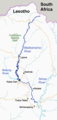
Afrikaans: Die Malibamat'so ontstaan in die Malutireeks, en word met die Bokong/Bokung deur die Katsedam opgedam. Verdere linkeroewer-sytakke is die Matsoku- en Semenyaneriviere voor dit by die regteroewer van die Senqu/Oranjerivier aansluit.
English: The Katse Dam impounds the Malibamat'so and Bokong/Bokung Rivers. Downstream the Malibamat'so's left bank tributaries are the Matsoku and Semenanyane Rivers, before it forms a right bank tributary of the Senqu/Orange River.
| Object location | | View all coordinates using: OpenStreetMap |
|---|
river in northern Lesotho  | |||||
| Upload media | |||||
| Instance of | |||||
|---|---|---|---|---|---|
| Location | Lesotho | ||||
| Length |
| ||||
| Mouth of the watercourse | |||||
| Drainage basin | |||||
 | |||||
Media in category "Malibamat'so River"
The following 9 files are in this category, out of 9 total.
-
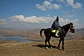
 Basotho on Horses.jpg 3,888 × 2,592; 3.58 MB
-
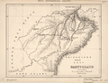 Basutoland WDL657.png 1,333 × 1,024; 2.39 MB
-
Katze Dam Malibamatso River.webm 2 min 34 s, 1,280 × 720; 32.18 MB
-
 LHWP map resized.jpg 3,555 × 5,000; 10.06 MB
-
 Malibamat'so River Lesotho.jpg 3,779 × 2,126; 4.2 MB
-
 Malibamat'so River.jpg 4,567 × 2,663; 6.37 MB
-
 Malibamatso.jpg 1,158 × 756; 1.12 MB
-
 Malibamatso1.png 464 × 980; 52 KB
-
 Mosotho.jpg 3,888 × 2,592; 3.43 MB


