Category:Maisemore
Jump to navigation
Jump to search
village and civil parish in Gloucestershire, United Kingdom  | |||||
| Upload media | |||||
| Instance of | |||||
|---|---|---|---|---|---|
| Location | Tewkesbury, Gloucestershire, South West England, England | ||||
| Population |
| ||||
| Said to be the same as | Maisemore (Wikimedia duplicated page, civil parish) | ||||
 | |||||
Subcategories
This category has the following 3 subcategories, out of 3 total.
M
- Maisemore bridge (6 F)
- Maisemore War Memorial (1 F)
Media in category "Maisemore"
The following 164 files are in this category, out of 164 total.
-
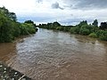 A bankfull river Severn from Maisemore bridge - geograph.org.uk - 3039747.jpg 1,600 × 1,200; 404 KB
-
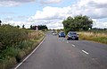
 A40 towards Cheltenham - geograph.org.uk - 6302426.jpg 800 × 600; 127 KB
-
 A417 at Maisemoor Ham - geograph.org.uk - 6721649.jpg 1,200 × 800; 1.09 MB
-
 A417 at Maisemore - geograph.org.uk - 2041295.jpg 640 × 480; 228 KB
-
 A417 at Maisemore village boundary - geograph.org.uk - 3047674.jpg 640 × 480; 83 KB
-
 A417 bends ahead - geograph.org.uk - 4108089.jpg 1,600 × 1,100; 350 KB
-
 A417 near Hartpury - geograph.org.uk - 3148229.jpg 640 × 480; 256 KB
-
 A417 near Maisemore - geograph.org.uk - 4108081.jpg 1,600 × 1,029; 344 KB
-
 A417 near Maisemore with a pylon - geograph.org.uk - 4450052.jpg 1,600 × 1,200; 1.26 MB
-
 A417 north of Overton - geograph.org.uk - 3047701.jpg 640 × 480; 55 KB
-
 A417 north west of Maisemore - geograph.org.uk - 3047695.jpg 640 × 480; 47 KB
-
 A417 south of Maisemore - geograph.org.uk - 2098974.jpg 640 × 480; 229 KB
-
 A417 through Maisemore - geograph.org.uk - 3815707.jpg 1,024 × 665; 144 KB
-
 A417 to Gloucester - geograph.org.uk - 2500918.jpg 800 × 600; 347 KB
-
 A417 towards Ledbury (showing roadsign) - geograph.org.uk - 503016.jpg 640 × 482; 113 KB
-
 A417 towards Ledbury - geograph.org.uk - 6302428.jpg 800 × 600; 136 KB
-
 A417 towards Maisemoore - geograph.org.uk - 4181422.jpg 1,600 × 1,073; 436 KB
-
 A417 towards Maisemore - geograph.org.uk - 3806748.jpg 1,600 × 1,142; 325 KB
-
 Abloads Court - geograph.org.uk - 83859.jpg 640 × 479; 85 KB
-
 Abloads Court, Sandford - geograph.org.uk - 778194.jpg 640 × 426; 81 KB
-
-
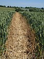
 Arable land at Maisemore - geograph.org.uk - 2404008.jpg 1,024 × 680; 205 KB
-
 At the Upper Parting - geograph.org.uk - 1936977.jpg 640 × 473; 113 KB
-
 Barley beside the River Severn - geograph.org.uk - 931268.jpg 640 × 426; 100 KB
-
 Base of a preaching cross - geograph.org.uk - 2404027.jpg 1,024 × 680; 285 KB
-
 Big sky over the Long Reach - geograph.org.uk - 5159106.jpg 1,200 × 1,600; 652 KB
-
 Blacksmiths Lane, Maisemore - geograph.org.uk - 725069.jpg 640 × 480; 161 KB
-
 Bridge Farm housing development - geograph.org.uk - 724555.jpg 640 × 480; 128 KB
-
 Bridleway and footpath by the Severn - geograph.org.uk - 711915.jpg 480 × 640; 206 KB
-
 Bridleway near maisemore - geograph.org.uk - 932571.jpg 640 × 426; 125 KB
-
 Brook and footpath running parallel - geograph.org.uk - 724511.jpg 480 × 640; 178 KB
-
 Built to last - geograph.org.uk - 725061.jpg 640 × 480; 125 KB
-
 Bus shelter in Maisemore - geograph.org.uk - 5597602.jpg 1,600 × 1,143; 724 KB
-
 Church Road, Maisemore - geograph.org.uk - 724503.jpg 640 × 472; 141 KB
-
 Cottages in Maisemore - geograph.org.uk - 725067.jpg 640 × 480; 118 KB
-
 Cycle path by the Severn - geograph.org.uk - 1937209.jpg 640 × 456; 95 KB
-
 Cycleway at Maisemore - geograph.org.uk - 724559.jpg 442 × 640; 187 KB
-
 Dilapidated pub sign - geograph.org.uk - 940593.jpg 476 × 640; 142 KB
-
 Ducking and diving - geograph.org.uk - 724541.jpg 640 × 450; 172 KB
-
 Farmland above Maisemore - geograph.org.uk - 4312417.jpg 1,024 × 680; 310 KB
-

-
 Field by Over Old Road - geograph.org.uk - 1936499.jpg 640 × 480; 110 KB
-
 Fish, Maisemore - geograph.org.uk - 1937088.jpg 640 × 452; 28 KB
-
 Flood level markers on the A417 - geograph.org.uk - 3047667.jpg 640 × 480; 67 KB
-
 Floodplain at Long Reach - geograph.org.uk - 5159101.jpg 1,600 × 1,200; 901 KB
-
 Footpath by a brook - geograph.org.uk - 724509.jpg 640 × 442; 178 KB
-
 Footpath from Maisemore - geograph.org.uk - 2537751.jpg 800 × 600; 411 KB
-
 Footpath near Overton - geograph.org.uk - 1936495.jpg 480 × 640; 142 KB
-
 Footpath near Woolridge - geograph.org.uk - 1936855.jpg 640 × 466; 92 KB
-
 Footpath near Woolridge - geograph.org.uk - 1936885.jpg 640 × 480; 112 KB
-
 Friendly type - geograph.org.uk - 725072.jpg 480 × 640; 216 KB
-
 Gloucester Over Junction up freight geograph-2930549-by-Ben-Brooksbank.jpg 2,391 × 1,335; 1.21 MB
-
 House in Maisemoor - geograph.org.uk - 6721703.jpg 1,200 × 800; 1 MB
-

-
 Lake at Maisemore - geograph.org.uk - 1937082.jpg 640 × 480; 104 KB
-
 Lake at Maisemore - geograph.org.uk - 724537.jpg 480 × 640; 133 KB
-
 Lake at Maisemore - geograph.org.uk - 725088.jpg 640 × 480; 166 KB
-
 Lake, Maisemore - geograph.org.uk - 1937040.jpg 480 × 640; 109 KB
-
 Lay-by by A417 north of Over Bridge - geograph.org.uk - 4450044.jpg 1,600 × 1,200; 1.41 MB
-
 Lay-by on A417 in Overton - geograph.org.uk - 4450327.jpg 1,600 × 1,067; 1.01 MB
-
 Long Reach on the Severn - geograph.org.uk - 1936937.jpg 640 × 480; 122 KB
-
 Longlevens Road - A38 Junction. - geograph.org.uk - 83602.jpg 640 × 479; 70 KB
-
 Maisemore Apiaries - geograph.org.uk - 1936526.jpg 640 × 421; 82 KB
-
 Maisemore Apiaries - geograph.org.uk - 4039994.jpg 4,320 × 3,240; 3.09 MB
-
 Maisemore Bridge - geograph.org.uk - 4040004.jpg 4,320 × 3,240; 2.78 MB
-
 Maisemore Bridge and cross - geograph.org.uk - 4450087.jpg 1,600 × 1,067; 1.36 MB
-
 Maisemore from the air - geograph.org.uk - 1221526.jpg 640 × 509; 76 KB
-
 Maisemore Ham - geograph.org.uk - 2098972.jpg 640 × 480; 240 KB
-
 Maisemore Village Hall - geograph.org.uk - 724506.jpg 640 × 480; 136 KB
-
 Maisemore Weir - geograph.org.uk - 1937005.jpg 484 × 640; 106 KB
-
 Mature orchard at Maisemore - geograph.org.uk - 931295.jpg 640 × 426; 83 KB
-
 Meadows near Woolridge - geograph.org.uk - 1401599.jpg 640 × 480; 101 KB
-

-
 Memorial on the side of the A417 - geograph.org.uk - 1541131.jpg 640 × 480; 145 KB
-

-
 National Cycle Route 45 - geograph.org.uk - 6302431.jpg 800 × 600; 179 KB
-
 Oilseed rape on Chargy Hill - geograph.org.uk - 2403999.jpg 1,024 × 680; 232 KB
-
 Orchard Way, Maisemore, Glos - geograph.org.uk - 6293074.jpg 640 × 480; 54 KB
-
 Ordnance Survey Cut Mark - geograph.org.uk - 4953377.jpg 598 × 640; 170 KB
-
 Over Junction geograph-2472000-by-Ben-Brooksbank.jpg 2,398 × 1,449; 767 KB
-
 Overton, farmland - geograph.org.uk - 1583242.jpg 640 × 480; 66 KB
-
 Overton, stile - geograph.org.uk - 1583252.jpg 640 × 480; 75 KB
-
 Parched field, Woolridge - geograph.org.uk - 2558847.jpg 800 × 600; 380 KB
-
 Pasture south of Woolridge - geograph.org.uk - 939739.jpg 640 × 480; 130 KB
-
 Path up High Redding Hill - geograph.org.uk - 2543800.jpg 800 × 600; 412 KB
-
 Path up High Redding Hill, 2016 - geograph.org.uk - 5159077.jpg 1,600 × 901; 738 KB
-
 Persh Farm - geograph.org.uk - 1937153.jpg 480 × 640; 95 KB
-
 Persh Lane, Maisemore - geograph.org.uk - 725064.jpg 480 × 640; 138 KB
-
 Phone box and bus shelter, Maisemore - geograph.org.uk - 725063.jpg 640 × 480; 130 KB
-
 Pond near the Severn - geograph.org.uk - 1936919.jpg 640 × 403; 79 KB
-
 Power line to Gloucester - geograph.org.uk - 1937168.jpg 640 × 448; 51 KB
-
 Power lines crossing Maisemore Ham - geograph.org.uk - 5597605.jpg 1,600 × 1,200; 727 KB
-
 Power Lines Over Maisemore Ham - geograph.org.uk - 83609.jpg 640 × 479; 84 KB
-
 Pylons on Alney Island - geograph.org.uk - 1937244.jpg 480 × 640; 65 KB
-
 Riding the Severn Bore - geograph.org.uk - 2896698.jpg 640 × 425; 347 KB
-
 Riding the Severn Bore - geograph.org.uk - 2896704.jpg 640 × 425; 348 KB
-
 River Severn - geograph.org.uk - 1936940.jpg 640 × 479; 83 KB
-
 River Severn - geograph.org.uk - 1936951.jpg 640 × 480; 88 KB
-
 River Severn - West Channel - geograph.org.uk - 2776151.jpg 1,024 × 680; 253 KB
-

-
 River Severn close to flood - geograph.org.uk - 323940.jpg 640 × 429; 137 KB
-

-
 River Severn from Maisemore Bridge - geograph.org.uk - 724553.jpg 640 × 480; 126 KB
-
 River Severn West Channel - geograph.org.uk - 2041274.jpg 640 × 481; 239 KB
-
 River Severn West Channel 2 - geograph.org.uk - 2041283.jpg 640 × 480; 216 KB
-

-
 River side footpath, Maisemore - geograph.org.uk - 931247.jpg 640 × 426; 116 KB
-
 Road above Hartpury - geograph.org.uk - 2403987.jpg 1,024 × 680; 226 KB
-
 Road junction at Woolridge - geograph.org.uk - 3095864.jpg 4,320 × 3,240; 2.89 MB
-
 Road junction in Maisemore - geograph.org.uk - 931305.jpg 640 × 426; 81 KB
-
 Road sign on the A417 looking towards Gloucester - geograph.org.uk - 2001531.jpg 1,600 × 1,200; 410 KB
-
 Road to Hartpury - geograph.org.uk - 2404002.jpg 1,024 × 680; 206 KB
-
 Road to Hartpury - geograph.org.uk - 2404010.jpg 1,024 × 680; 187 KB
-
 Road west from Over roundabout - geograph.org.uk - 1876712.jpg 640 × 480; 57 KB
-
 Semi-detached thatched, Maisemore - geograph.org.uk - 725075.jpg 640 × 480; 165 KB
-
 Severn above Maisemore Weir - geograph.org.uk - 1936985.jpg 640 × 480; 97 KB
-
 Severn Bore - geograph.org.uk - 2896690.jpg 640 × 425; 354 KB
-
 Severn floodplain - geograph.org.uk - 2041303.jpg 640 × 480; 238 KB
-
 Severn floodplain - geograph.org.uk - 2543805.jpg 800 × 600; 397 KB
-
 Severn Floodplain, 2016 - geograph.org.uk - 5159099.jpg 1,600 × 901; 724 KB
-
 Severn valley near Sandhurst - geograph.org.uk - 1936906.jpg 640 × 427; 71 KB
-
 St Giles Church - geograph.org.uk - 6721680.jpg 1,200 × 802; 1.15 MB
-
 St Giles, Maisemore - geograph.org.uk - 3474586.jpg 3,366 × 2,259; 1.89 MB
-
 St Giles, Maisemore - geograph.org.uk - 3474602.jpg 3,456 × 2,592; 1.36 MB
-
 St Giles, Maisemore - geograph.org.uk - 3474626.jpg 3,456 × 2,592; 3.86 MB
-
 Stanleigh Terrace, Maisemore - geograph.org.uk - 725080.jpg 620 × 640; 228 KB
-
 Thatched cottage, Maisemore - geograph.org.uk - 725062.jpg 640 × 444; 160 KB
-
 The A417 rises over Maisemore Bridge - geograph.org.uk - 2003694.jpg 640 × 480; 52 KB
-
 The A417 towards Maisemore - geograph.org.uk - 2003668.jpg 640 × 480; 86 KB
-
 The churchyard, Maisemore (geograph 7501936).jpg 1,024 × 768; 225 KB
-
 The Coal Yard - geograph.org.uk - 2462399.jpg 3,088 × 2,056; 1.37 MB
-
 The end of Old Road, Maisemore - geograph.org.uk - 4450322.jpg 1,600 × 1,201; 1.24 MB
-

-
 The lane from the churchyard - geograph.org.uk - 1464040.jpg 480 × 640; 71 KB
-
 The Rising Sun - geograph.org.uk - 2558831.jpg 800 × 600; 394 KB
-
 The Rising Sun - geograph.org.uk - 939723.jpg 640 × 480; 93 KB
-
 The river Severn at Maisemore - geograph.org.uk - 5676632.jpg 640 × 480; 48 KB
-
 The Rudge, Maisemore - geograph.org.uk - 725059.jpg 480 × 640; 188 KB
-
 The Steadings - geograph.org.uk - 1464054.jpg 640 × 365; 69 KB
-
 The Steadings Business Centre - geograph.org.uk - 2404034.jpg 1,024 × 680; 187 KB
-
 The Steadings Business Centre, Maisemore - geograph.org.uk - 724517.jpg 640 × 480; 118 KB
-
 The White Hart - geograph.org.uk - 6721653.jpg 1,200 × 805; 877 KB
-
 The White Hart at Maisemore - geograph.org.uk - 5538702.jpg 640 × 480; 47 KB
-
 The White Hart inn, Maisemore - geograph.org.uk - 4450090.jpg 1,600 × 1,203; 1.21 MB
-
-
 The White Hart, Maisemore - geograph.org.uk - 4981377.jpg 1,600 × 1,065; 553 KB
-
 The White Hart, Maisemore - geograph.org.uk - 4981382.jpg 1,194 × 1,600; 281 KB
-
 Timbered cottage, Maisemore - geograph.org.uk - 725076.jpg 640 × 480; 165 KB
-
 Track near Over Farm - geograph.org.uk - 435515.jpg 640 × 426; 129 KB
-
 View across the Severn - geograph.org.uk - 2566201.jpg 800 × 600; 347 KB
-
 View across the Severn's West Channel - geograph.org.uk - 2041312.jpg 640 × 480; 234 KB
-
 View to Sandhurst Hill - geograph.org.uk - 2403996.jpg 1,024 × 680; 199 KB
-
 View to the Cotswolds - geograph.org.uk - 2403989.jpg 1,024 × 680; 180 KB
-
 Village entrance for Maisemore on A417 - geograph.org.uk - 5597599.jpg 1,600 × 1,144; 793 KB
-
 Wheat near Maisemore - geograph.org.uk - 1937145.jpg 640 × 480; 92 KB
-
 Young rape crop near Maisemore Park - geograph.org.uk - 5159093.jpg 1,600 × 901; 690 KB
-
 Brook running down to join the Severn - geograph.org.uk - 711920.jpg 480 × 640; 219 KB
-
 Fallen trees by the Severn - geograph.org.uk - 711929.jpg 640 × 480; 163 KB
-
 Footpath by the Severn - geograph.org.uk - 711921.jpg 480 × 640; 190 KB
-
 Home Farm, Maisemore - geograph.org.uk - 83612.jpg 640 × 479; 121 KB
-
 Horsbere Brook near Walham - geograph.org.uk - 774966.jpg 640 × 426; 105 KB
-
 Lower parting Gloucester - geograph.org.uk - 123668.jpg 640 × 480; 88 KB
-
 Persh Farm - geograph.org.uk - 85594.jpg 640 × 479; 148 KB
-
 Road Merger, Linton - geograph.org.uk - 137678.jpg 640 × 479; 40 KB


_-_geograph.org.uk_-_503016.jpg)


.jpg)


