Category:Mairie de Ribérac
Jump to navigation
Jump to search
| Object location | | View all coordinates using: OpenStreetMap |
|---|
|
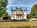
This building is indexed in the base Mérimée, a database of architectural heritage maintained by the French Ministry of Culture, under the reference IA24000512
|
Français : Construit au XIXe siècle, le bâtiment de la mairie, a d'abord abrité la sous-préfecture (jusqu'en 1926) puis un lycée ; Ribérac, Dordogne, France.
town hall located in Dordogne department, France  | |||||
| Upload media | |||||
| Instance of |
| ||||
|---|---|---|---|---|---|
| Location | Ribérac, Dordogne, Nouvelle-Aquitaine, Metropolitan France, France | ||||
| Street address |
| ||||
| Has use | |||||
| Owned by | |||||
| Operator | |||||
 | |||||
Media in category "Mairie de Ribérac"
The following 32 files are in this category, out of 32 total.
-
 Demeure, puis sous-préfecture, puis lycée, actuellement mairie.jpg 4,896 × 3,672; 9.08 MB
-
 Ribérac mairie (1).JPG 3,264 × 2,448; 3.67 MB
-
 Ribérac mairie (2).JPG 3,264 × 2,448; 3.7 MB
-
 Ribérac mairie (3).JPG 3,264 × 2,448; 3.29 MB
-
 Ribérac mairie (5).JPG 3,264 × 2,448; 1.59 MB
-
 Ribérac Mairie - Septembre 2016 HDR Enhanced.jpg 2,845 × 2,133; 1,003 KB
-
 Ribérac Mairie - Septembre 2016 HDR.jpg 2,845 × 2,133; 1.64 MB
-
 Ribérac mairie balcon (1).JPG 3,264 × 2,448; 1.93 MB
-
 Ribérac mairie balcon consoles.JPG 3,264 × 2,448; 1.51 MB
-
 Ribérac mairie balcon.JPG 3,264 × 2,448; 1.76 MB
-
 Ribérac mairie cheminée.JPG 2,448 × 3,264; 3.77 MB
-
 Ribérac mairie clés.JPG 3,264 × 2,448; 3.84 MB
-
 Ribérac mairie coquille.JPG 3,264 × 2,448; 3.76 MB
-
 Ribérac mairie fenêtre décor.JPG 3,264 × 2,448; 3.73 MB
-
 Ribérac mairie linteau (1).JPG 3,264 × 2,448; 1.49 MB
-
 Ribérac mairie linteau (2).JPG 3,264 × 2,448; 1.6 MB
-
 Ribérac mairie linteau (3).JPG 3,264 × 2,448; 1.3 MB
-
 Ribérac mairie linteau (4).JPG 3,264 × 2,448; 1.34 MB
-
 Ribérac mairie linteau (6).JPG 3,264 × 2,448; 1.39 MB
-
 Ribérac mairie linteau (7).JPG 3,264 × 2,448; 3.71 MB
-
 Ribérac mairie linteau.JPG 3,264 × 2,448; 1.28 MB
-
 Ribérac mairie lucarne (1).JPG 3,199 × 2,401; 1.53 MB
-
 Ribérac mairie lucarne (2).JPG 3,264 × 2,448; 1.78 MB
-
 Ribérac mairie lucarne (4).JPG 2,448 × 3,264; 3.75 MB
-
 Ribérac mairie lucarne (5).JPG 3,161 × 2,372; 1.64 MB
-
 Ribérac mairie lucarne fronton (1).JPG 3,264 × 2,448; 3.58 MB
-
 Ribérac mairie lucarne fronton.JPG 3,264 × 2,448; 3.74 MB
-
 Ribérac mairie lucarne.JPG 3,264 × 2,448; 3.71 MB
-
 Ribérac mairie tourelle (3).JPG 3,264 × 2,448; 3.76 MB
-
 Ribérac mairie tourelle socle.JPG 2,448 × 3,264; 3.56 MB
-
 Ribérac mairie.JPG 3,264 × 2,448; 2.6 MB
-
 Ribérac Wikivoyage Banner.jpg 2,797 × 405; 317 KB

.JPG)
.JPG)
.JPG)
.JPG)

.JPG)


.JPG)
.JPG)
.JPG)
.JPG)
.JPG)
.JPG)

.JPG)
.JPG)
.JPG)
.JPG)
.JPG)


.JPG)

