Category:Magor with Undy
Jump to navigation
Jump to search
community in Monmouthshire, Wales | |||||
| Upload media | |||||
| Pronunciation audio | |||||
|---|---|---|---|---|---|
| Instance of | |||||
| Location | Monmouthshire, Wales | ||||
 | |||||
Subcategories
This category has the following 2 subcategories, out of 2 total.
M
U
Media in category "Magor with Undy"
The following 200 files are in this category, out of 563 total.
(previous page) (next page)-
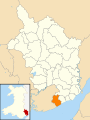 2010 Wales Monmouthshire Community Magor with Undy map.svg 512 × 682; 699 KB
-
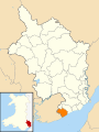 2024 Wales Monmouthshire Community Magor with Undy map.svg 512 × 682; 603 KB
-

-
 A Laserwash 360 car wash, Magor Services - geograph.org.uk - 3336185.jpg 640 × 530; 126 KB
-

-
 Acacia Avenue, Undy - geograph.org.uk - 5676697.jpg 800 × 528; 77 KB
-
-
 Access lane to Waun-arw Farm near Magor - geograph.org.uk - 3712830.jpg 800 × 600; 132 KB
-

-
 Across the Car Park to the Services ^ Hotel - geograph.org.uk - 6187821.jpg 4,032 × 1,908; 2.21 MB
-
 Across the common - panoramio.jpg 2,560 × 1,920; 3.05 MB
-
 Angelo's Fish Bar, Magor - geograph.org.uk - 5671543.jpg 800 × 666; 130 KB
-
 Approach ramps to a new footbridge in Undy - geograph.org.uk - 5403916.jpg 4,000 × 3,000; 3.25 MB
-
 Approaching Magor from the south - geograph.org.uk - 3741074.jpg 799 × 800; 201 KB
-

-
 Arlington Close, Undy - geograph.org.uk - 2033247.jpg 640 × 466; 69 KB
-
 B4245 leaves Magor - geograph.org.uk - 2039775.jpg 640 × 480; 69 KB
-
 Baby swan - geograph.org.uk - 1902156.jpg 3,648 × 2,736; 1.84 MB
-
 Ballast train at Undy - geograph.org.uk - 5403897.jpg 3,767 × 2,825; 4.24 MB
-
 Barecroft Common - panoramio - Ray Ok.jpg 1,944 × 2,592; 1.17 MB
-
 Barecroft Common - panoramio.jpg 2,592 × 1,944; 1.19 MB
-
 Barecroft Common next to the Blackwall stud - panoramio.jpg 2,048 × 1,536; 769 KB
-
-
 Bareland Street Reen near Llandevenny - geograph.org.uk - 4405768.jpg 800 × 600; 181 KB
-
 Bareland Street towards Llandevenny - geograph.org.uk - 4405164.jpg 800 × 599; 128 KB
-
 Barns beside the lane - geograph.org.uk - 3190682.jpg 640 × 480; 58 KB
-
 Be-Glitz in Magor - geograph.org.uk - 5671006.jpg 800 × 784; 121 KB
-
 Bend in Bareland Street near Llandevenny - geograph.org.uk - 4405218.jpg 800 × 481; 136 KB
-
 Bend in the Dancing Hill pavement, Undy - geograph.org.uk - 5678493.jpg 800 × 652; 145 KB
-
 Black 5 at Magor - geograph.org.uk - 5198755.jpg 4,000 × 3,000; 2.29 MB
-
 Bliss in Magor - geograph.org.uk - 5670948.jpg 725 × 800; 101 KB
-
 Blue Cumin, 5 The Square, Magor - geograph.org.uk - 5671001.jpg 749 × 800; 126 KB
-
 Boardwalk, Magor Marsh Nature Reserve - geograph.org.uk - 5524985.jpg 5,179 × 3,451; 5.49 MB
-
-
 Brewery storage containers, Magor - geograph.org.uk - 2039747.jpg 640 × 447; 44 KB
-

-
 Bridge under the M4 at Magor - geograph.org.uk - 4863335.jpg 640 × 444; 99 KB
-
 Bridgend Farm - geograph.org.uk - 6241873.jpg 2,411 × 1,671; 1.31 MB
-
 BT phonebox in The Square, Magor - geograph.org.uk - 5670999.jpg 800 × 798; 160 KB
-
 Bungalows in The Gardens, Magor - geograph.org.uk - 3712907.jpg 800 × 527; 82 KB
-

-
 Bungalows on Main Road, Undy - geograph.org.uk - 6302032.jpg 640 × 333; 62 KB
-

-
 Byway to Castell Coch - geograph.org.uk - 4212241.jpg 800 × 451; 248 KB
-
 Caldecot Level - geograph.org.uk - 1243151.jpg 640 × 480; 91 KB
-

-

-
 Cattle in Salisbury Hill - geograph.org.uk - 4212244.jpg 800 × 451; 274 KB
-

-
 Chapel Terrace, Magor - geograph.org.uk - 5670314.jpg 800 × 419; 84 KB
-
 Chestnut Close, Magor - geograph.org.uk - 5671203.jpg 800 × 502; 102 KB
-
 Church of St Mary, Undy - geograph.org.uk - 5403921.jpg 4,000 × 3,000; 3.66 MB
-
 Church Road, Undy - geograph.org.uk - 2033213.jpg 640 × 431; 62 KB
-
 Class 769 delivery at Undy - geograph.org.uk - 6363938.jpg 4,773 × 3,579; 5.37 MB
-
 Classic Hair Salon, The Square, Magor - geograph.org.uk - 5670643.jpg 800 × 750; 145 KB
-
 Collister Pill Reen - geograph.org.uk - 5403870.jpg 640 × 480; 115 KB
-
-

-

-
 Cottages on Chapel Terrace, Magor - geograph.org.uk - 4862776.jpg 640 × 480; 82 KB
-
 Cotton Traders, Magor Services - geograph.org.uk - 3336129.jpg 640 × 410; 84 KB
-
 Cowleaze, Magor - geograph.org.uk - 5678391.jpg 800 × 551; 125 KB
-

-
 Cross-Country HST at Magor - geograph.org.uk - 5930697.jpg 4,231 × 3,173; 5.25 MB
-
 Damp meadow, Magor Marsh Nature Reserve - geograph.org.uk - 5524695.jpg 5,179 × 3,451; 4.77 MB
-
 Dancing Close in Undy - geograph.org.uk - 5676770.jpg 800 × 516; 88 KB
-
 Dancing Hill, Magor - geograph.org.uk - 4212238.jpg 800 × 451; 201 KB
-
 Dancing Hill, Magor - geograph.org.uk - 5671232.jpg 800 × 583; 112 KB
-
 Dawn at Magor Services, M4 - geograph.org.uk - 5526479.jpg 5,184 × 3,456; 6.77 MB
-
 Day's Inn, Magor Services - geograph.org.uk - 3336077.jpg 640 × 371; 69 KB
-
 Days Inn (Magor Services) - geograph.org.uk - 6187816.jpg 4,032 × 1,908; 2.43 MB
-
 Dead-end minor road in Knollbury - geograph.org.uk - 5681022.jpg 800 × 530; 108 KB
-

-

-

-
 Derelict buildings, Undy - geograph.org.uk - 2033721.jpg 640 × 480; 101 KB
-
-
 Detached houses, Undy - geograph.org.uk - 2033573.jpg 640 × 511; 100 KB
-
 DH Jones Driver Training - geograph.org.uk - 5403873.jpg 640 × 480; 76 KB
-
 Dinch Hill electricity substation, Undy - geograph.org.uk - 5678420.jpg 800 × 579; 182 KB
-
 Dinch Hill Lane, Undy - geograph.org.uk - 2033944.jpg 640 × 520; 84 KB
-
 Dinch Hill, Undy - geograph.org.uk - 5678422.jpg 608 × 800; 193 KB
-
 Dipping platform at Magor Marsh - geograph.org.uk - 4862993.jpg 640 × 480; 107 KB
-

-

-
 Down Dancing Hill, Undy - geograph.org.uk - 5680884.jpg 800 × 681; 114 KB
-
 Drains on the Caldecot Level - geograph.org.uk - 1243184.jpg 640 × 480; 101 KB
-

-
 East along Grange Road, Undy - geograph.org.uk - 5680929.jpg 800 × 696; 120 KB
-

-
 Eastern boundary of Undy - geograph.org.uk - 2033158.jpg 640 × 510; 70 KB
-
 Ebenezer Baptist Church, Magor - geograph.org.uk - 5140965.jpg 640 × 480; 193 KB
-
 Ebenezer Baptist Church, Magor - geograph.org.uk - 5140975.jpg 640 × 480; 212 KB
-
 Eden in Magor - geograph.org.uk - 5671010.jpg 800 × 576; 89 KB
-
 Elm Cottage, Undy - geograph.org.uk - 2033197.jpg 640 × 445; 61 KB
-
 Elms Hill, Undy - geograph.org.uk - 2033235.jpg 640 × 391; 50 KB
-

-

-

-

-

-

-

-

-

-
 Field boundary near Magor - geograph.org.uk - 2266722.jpg 2,112 × 2,816; 2.11 MB
-
 Field by Common-y-Coed - geograph.org.uk - 4212210.jpg 800 × 451; 182 KB
-
 Field edge footpath - geograph.org.uk - 3190688.jpg 640 × 480; 90 KB
-
 Field near Magor Sewage Works - geograph.org.uk - 5404003.jpg 640 × 480; 78 KB
-
 Field west of Upper Seven Acres Wood - geograph.org.uk - 4209274.jpg 800 × 451; 194 KB
-
 Fields near Lower Grange - geograph.org.uk - 2266712.jpg 2,816 × 2,112; 1.94 MB
-
 Flying Scotsman at Undy - geograph.org.uk - 5403931.jpg 3,788 × 2,841; 5.38 MB
-
 Flying Scotsman at Undy - geograph.org.uk - 5403933.jpg 3,333 × 2,499; 3.11 MB
-
 Footpath signpost, Grange Road, Undy - geograph.org.uk - 5680910.jpg 541 × 800; 149 KB
-
 Footpath to Common-y-Coed - geograph.org.uk - 4209277.jpg 800 × 451; 207 KB
-
 Footway to the truck stop - geograph.org.uk - 5012725.jpg 6,000 × 4,000; 7.78 MB
-
-
 Freight Train at Magor - geograph.org.uk - 3829773.jpg 1,200 × 811; 1.35 MB
-
 From 20 to 30 on Newport Road, Magor - geograph.org.uk - 5671567.jpg 720 × 800; 150 KB
-
 Gamma Projects Head Office, Magor - geograph.org.uk - 1837930.jpg 640 × 451; 60 KB
-
 Gate to Magor Marsh Nature Reserve - geograph.org.uk - 2689608.jpg 640 × 480; 94 KB
-
 Georgian building, Magor - geograph.org.uk - 1078188.jpg 640 × 480; 74 KB
-
-
 Glenview, Magor - geograph.org.uk - 1838088.jpg 640 × 480; 59 KB
-
 Golden Lion depiction, Magor - geograph.org.uk - 5670964.jpg 640 × 473; 56 KB
-
 Golden Lion name sign, Magor - geograph.org.uk - 5670966.jpg 550 × 800; 87 KB
-
 Grange Road stile to a footpath, Undy - geograph.org.uk - 5680906.jpg 800 × 799; 136 KB
-
 Grazia, 2 The Square, Magor - geograph.org.uk - 5670976.jpg 800 × 594; 83 KB
-
 Green Wall Reen - geograph.org.uk - 5403871.jpg 640 × 480; 82 KB
-
 Greenfields Nursery, Magor - geograph.org.uk - 1838072.jpg 640 × 480; 80 KB
-
 Hampton by Hilton hotel, Magor - geograph.org.uk - 3472019.jpg 800 × 612; 124 KB
-

-

-
 Harvested maize field - geograph.org.uk - 4212212.jpg 800 × 451; 221 KB
-
 Hawthorn Close, Undy - geograph.org.uk - 5676751.jpg 800 × 471; 118 KB
-
 Hay in transit near Magor - geograph.org.uk - 3712824.jpg 800 × 620; 81 KB
-
 Hay rake at Magor Marsh - geograph.org.uk - 5198744.jpg 4,000 × 3,000; 4.18 MB
-
 Hay rake, Magor Marsh - geograph.org.uk - 5138259.jpg 640 × 480; 210 KB
-

-

-

-

-
 In Magor Services car park - geograph.org.uk - 4987649.jpg 640 × 479; 46 KB
-
 Information board and postbox in Magor - geograph.org.uk - 3741139.jpg 800 × 800; 184 KB
-
 Information board, Magor Marsh - geograph.org.uk - 5138261.jpg 640 × 427; 152 KB
-
 Johnsey building site, Main Road, Undy - geograph.org.uk - 5676944.jpg 800 × 560; 145 KB
-

-

-
-

-
 Kegs and a pylon near Magor - geograph.org.uk - 3741063.jpg 799 × 800; 160 KB
-
 King Edward I departs Magor - geograph.org.uk - 2709713.jpg 4,000 × 3,000; 3.47 MB
-
 King George VI postbox, Knollbury - geograph.org.uk - 5681014.jpg 800 × 600; 177 KB
-
 Kingfisher Cottage, Whitewall, Magor - geograph.org.uk - 5673540.jpg 800 × 636; 170 KB
-

-
 Knollbury this way from Undy - geograph.org.uk - 5678451.jpg 800 × 591; 112 KB
-
 Laburnum Close, Undy - geograph.org.uk - 5676724.jpg 800 × 559; 112 KB
-
 Lager cans at Magor - geograph.org.uk - 3190545.jpg 640 × 480; 53 KB
-

-

-
 Lane to Upper Grange Farm near Magor - geograph.org.uk - 3712486.jpg 800 × 706; 134 KB
-
 Langley Close, Magor - geograph.org.uk - 3712884.jpg 800 × 562; 81 KB
-
 Langley Terrace, Magor - geograph.org.uk - 3712887.jpg 800 × 702; 109 KB
-

-
 Laurel Close, Undy - geograph.org.uk - 5676699.jpg 800 × 600; 102 KB
-
 Left here for Llandevenny - geograph.org.uk - 4405168.jpg 800 × 638; 155 KB
-
 Left turn only at junction near Magor - geograph.org.uk - 4405774.jpg 800 × 559; 118 KB
-
 Leys Brake - geograph.org.uk - 4212205.jpg 800 × 451; 185 KB
-
 Local Train passing Undy - geograph.org.uk - 2991401.jpg 1,024 × 690; 994 KB
-
-

-

-
 Lower Grange Farm south of Magor - geograph.org.uk - 2686051.jpg 640 × 498; 114 KB
-
 Lunch stop - geograph.org.uk - 3781700.jpg 1,600 × 1,200; 561 KB
-

-
 M4 at Undy - geograph.org.uk - 6222599.jpg 3,592 × 1,105; 1.51 MB
-
 M4 climbing towards Knollbury summit - geograph.org.uk - 2059696.jpg 640 × 480; 57 KB
-
 M4 eastbound approaching junction 23 - geograph.org.uk - 3717209.jpg 2,309 × 1,403; 1.87 MB
-
 M4 eastbound near Knollbury - geograph.org.uk - 3792916.jpg 640 × 480; 48 KB
-
 M4 entering Newport - geograph.org.uk - 3666033.jpg 640 × 430; 37 KB
-
 M4 entering Newport - geograph.org.uk - 6222606.jpg 4,128 × 2,006; 2.89 MB
-
 M4 looking east - geograph.org.uk - 4212227.jpg 800 × 451; 247 KB
-

-
 M4 motorway access road, Magor - geograph.org.uk - 1837938.jpg 640 × 480; 63 KB
-
 M4 Motorway approaching junction 23 - geograph.org.uk - 2059707.jpg 640 × 480; 57 KB
-
 M4 Motorway approaching junction 23a - geograph.org.uk - 2059686.jpg 640 × 480; 60 KB
-
 M4 Motorway at junction 23 - geograph.org.uk - 2080567.jpg 640 × 480; 61 KB
-
 M4 Motorway east of junction 23a - geograph.org.uk - 2059694.jpg 640 × 480; 59 KB
-
 M4 west at Magor - geograph.org.uk - 4212221.jpg 800 × 451; 231 KB
-
-
 M4 westbound at Newport boundary - geograph.org.uk - 3262412.jpg 640 × 480; 36 KB
-
 M4, Junction 23a - geograph.org.uk - 3666031.jpg 640 × 400; 36 KB
-
 M48, M4 and Second Severn Crossing - geograph.org.uk - 2845583.jpg 640 × 480; 60 KB
-
 Magor , Car Park - geograph.org.uk - 5412701.jpg 5,488 × 3,659; 6.24 MB
-
 Magor , Chestnut Close - geograph.org.uk - 5412941.jpg 5,805 × 3,870; 7.49 MB
-
 Magor , Driveway - geograph.org.uk - 5412703.jpg 6,000 × 4,000; 7.35 MB
-
 Magor , Magor Hand Car Wash - geograph.org.uk - 5412934.jpg 6,000 × 4,000; 6.47 MB
-
 Magor , Main Road B4245 - geograph.org.uk - 5412697.jpg 6,000 × 4,000; 6.57 MB
-
 Magor , Main Road B4245 - geograph.org.uk - 5412698.jpg 6,000 × 4,000; 5.91 MB
-
 Magor , Main Road B4245 - geograph.org.uk - 5412700.jpg 6,000 × 4,000; 7.44 MB


_-_geograph.org.uk_-_6187816.jpg)


_in_a_field_near_Magor_-_geograph.org.uk_-_3712822.jpg)


