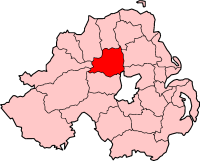
Category:Magherafelt (district)
Jump to navigation
Jump to search
Districts of Northern Ireland (1972-2015): Antrim · Ards · Armagh · Ballymena · Ballymoney · Banbridge · Belfast · Carrickfergus · Castlereagh · Coleraine · Cookstown · Craigavon · Derry · Down · Dungannon and South Tyrone · Fermanagh · Larne · Limavady · Lisburn · Magherafelt · Moyle · Newtownabbey · Newry and Mourne · North Down · Omagh · Strabane ·
administrative territorial entity of the United Kingdom | |||||
| Upload media | |||||
| Instance of |
| ||||
|---|---|---|---|---|---|
| Location | Mid Ulster, Northern Ireland | ||||
| Capital | |||||
| Area |
| ||||
| Religion or worldview | |||||
| official website | |||||
 | |||||
Magherafelt was a district of Northern Ireland from 1972 until 2015 administered by Magherafelt District Council. It was within County Londonderry. In 2015 it became Mid Ulster district administered by Mid Ulster District Council
Subcategories
This category has the following 4 subcategories, out of 4 total.
H
M
T
Media in category "Magherafelt (district)"
The following 2 files are in this category, out of 2 total.
-
Magherafelt 2005 election.svg 1,156 × 851; 322 KB
-
Magherafelt 2011 election.svg 1,156 × 851; 322 KB


