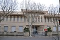
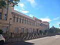
Category:Lycée Victor Hugo (Carpentras)
Jump to navigation
Jump to search
| Object location | | View all coordinates using: OpenStreetMap |
|---|
|
This building is indexed in the base Mérimée, a database of architectural heritage maintained by the French Ministry of Culture, under the reference IA84000722
|
 | |||||
| Upload media | |||||
| Instance of | |||||
|---|---|---|---|---|---|
| Location | Carpentras, Canton of Carpentras-Nord | ||||
| Street address |
| ||||
| Heritage designation | |||||
| official website | |||||
 | |||||
Media in category "Lycée Victor Hugo (Carpentras)"
The following 9 files are in this category, out of 9 total.
-
 Carpentras - Lycée Victor Hugo 1.JPG 4,608 × 3,072; 3.55 MB
-
 Carpentras - Lycée Victor Hugo 2.JPG 4,608 × 3,072; 3.54 MB
-
 Carpentras - Lycée Victor Hugo 3.JPG 4,608 × 3,072; 3.5 MB
-
 Carpentras - Lycée Victor Hugo 4.JPG 4,608 × 3,072; 4.02 MB
-
 Carpentras - Lycée Victor Hugo 5.JPG 4,608 × 3,072; 3.6 MB
-
 Carpentras - Lycée Victor Hugo 6.JPG 4,608 × 3,072; 3.81 MB
-
 Carpentras - Lycée Victor Hugo 7.JPG 3,072 × 4,608; 3.52 MB
-
 Carpentras - Lycée Victor Hugo 8.JPG 4,608 × 3,072; 3.56 MB
-
 Lycée Victor-Hugo.jpg 3,264 × 2,448; 1.37 MB


