Category:Lycée Gerville-Réache
Jump to navigation
Jump to search
| Object location | | View all coordinates using: OpenStreetMap |
|---|
|
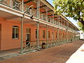
This building is inscrit au titre des monuments historiques de la France. It is indexed in the base Mérimée, a database of architectural heritage maintained by the French Ministry of Culture, under the reference PA00105851
|
educational facility in Basse-Terre, France  | |||||
| Upload media | |||||
| Instance of |
| ||||
|---|---|---|---|---|---|
| Location | Basse-Terre, Guadeloupe, France | ||||
| Street address |
| ||||
| Operator | |||||
| Heritage designation |
| ||||
| Inception |
| ||||
| official website | |||||
 | |||||
Media in category "Lycée Gerville-Réache"
The following 12 files are in this category, out of 12 total.
-
 Lycée Gerville-Réache (buste de Gaston Gerville-Réache 1854-1908).jpg 4,608 × 3,456; 5.21 MB
-
 Lycée Gerville-Réache 01.JPG 4,206 × 3,104; 7.19 MB
-
 Lycée Gerville-Réache 02.JPG 4,288 × 3,216; 5.84 MB
-
 Lycée Gerville-Réache 03.JPG 4,288 × 3,216; 5.66 MB
-
 Lycée Gerville-Réache 04.JPG 4,288 × 3,216; 5.55 MB
-
 Lycée Gerville-Réache 05.JPG 4,288 × 3,216; 5.61 MB
-
 Lycée Gerville-Réache 06.JPG 4,288 × 3,216; 7.58 MB
-
 Lycée Gerville-Réache 07.JPG 3,106 × 4,208; 5.2 MB
-
 Lycée Gerville-Réache 08.JPG 4,288 × 3,216; 5.92 MB
-
 Lycée Gerville-Réache 09.JPG 4,288 × 3,216; 5.11 MB
-
 Lycée Gerville-Réache 10.JPG 3,216 × 4,288; 5.91 MB
-
 Lycée Gerville-Réache 11.JPG 4,288 × 3,216; 5.69 MB
.jpg)


