Category:Lutherse Kerk (Groede)
Jump to navigation
Jump to search
| Object location | | View all coordinates using: OpenStreetMap |
|---|
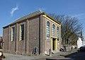
lutheran church in Groede, Netherlands  | |||||
| Upload media | |||||
| Instance of | |||||
|---|---|---|---|---|---|
| Location | Groede, Zeeland, Netherlands | ||||
| Street address |
| ||||
| Located on street |
| ||||
| Heritage designation |
| ||||
| Inception |
| ||||
| Significant event |
| ||||
| Religion or worldview | |||||
 | |||||
|
This is a category about rijksmonument number 31514
|
| Address |
|
Media in category "Lutherse Kerk (Groede)"
The following 3 files are in this category, out of 3 total.
-

-
 Groede Molenstraat 28 Evangelisch-Lutherse Kerk.JPG 3,932 × 2,906; 2.44 MB
-
 Lutherse Kerk Groede.JPG 1,860 × 1,317; 630 KB

