Category:Lučina (Nemanice)
Jump to navigation
Jump to search
| Object location | | View all coordinates using: OpenStreetMap |
|---|
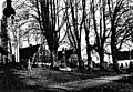
abandoned village in the Czech Republic  | |||||
| Upload media | |||||
| Instance of | |||||
|---|---|---|---|---|---|
| Location | Nemanice, Domažlice District, Plzeň Region, Czechia | ||||
 | |||||
Subcategories
This category has the following 2 subcategories, out of 2 total.
G
- Grafenriedské lípy (16 F)
Media in category "Lučina (Nemanice)"
The following 200 files are in this category, out of 208 total.
(previous page) (next page)-
 ... to co zbylo - panoramio.jpg 2,592 × 1,944; 1.97 MB
-
 Grafenried - hřbitov - panoramio (1).jpg 2,448 × 3,264; 3.76 MB
-
 Grafenried - hřbitov - panoramio.jpg 3,264 × 2,448; 3.54 MB
-
 Grafenried - Lučina - panoramio.jpg 2,592 × 1,944; 1.97 MB
-
 Grafenried - panoramio (1).jpg 3,264 × 2,448; 4.35 MB
-
 Grafenried - panoramio (10).jpg 3,264 × 2,448; 3.56 MB
-
 Grafenried - panoramio (11).jpg 3,264 × 2,448; 2.52 MB
-
 Grafenried - panoramio (12).jpg 3,264 × 2,448; 4.18 MB
-
 Grafenried - panoramio (13).jpg 3,264 × 2,448; 3.29 MB
-
 Grafenried - panoramio (14).jpg 3,264 × 2,448; 3.62 MB
-
 Grafenried - panoramio (15).jpg 3,264 × 2,448; 3.6 MB
-
 Grafenried - panoramio (16).jpg 3,264 × 2,448; 3.21 MB
-
 Grafenried - panoramio (17).jpg 3,264 × 2,448; 3.11 MB
-
 Grafenried - panoramio (18).jpg 3,264 × 2,448; 3.18 MB
-
 Grafenried - panoramio (19).jpg 3,264 × 2,448; 3.61 MB
-
 Grafenried - panoramio (2).jpg 3,264 × 2,448; 4.17 MB
-
 Grafenried - panoramio (20).jpg 3,264 × 2,448; 3.3 MB
-
 Grafenried - panoramio (21).jpg 3,264 × 2,448; 3.59 MB
-
 Grafenried - panoramio (22).jpg 3,264 × 2,448; 4.19 MB
-
 Grafenried - panoramio (23).jpg 3,264 × 2,448; 4.33 MB
-
 Grafenried - panoramio (24).jpg 3,264 × 2,448; 3.88 MB
-
 Grafenried - panoramio (25).jpg 3,264 × 2,448; 1.99 MB
-
 Grafenried - panoramio (26).jpg 3,264 × 2,448; 3.45 MB
-
 Grafenried - panoramio (27).jpg 3,264 × 2,448; 3.72 MB
-
 Grafenried - panoramio (28).jpg 3,264 × 2,448; 3.48 MB
-
 Grafenried - panoramio (29).jpg 3,264 × 2,448; 3.45 MB
-
 Grafenried - panoramio (3).jpg 3,264 × 2,448; 2.55 MB
-
 Grafenried - panoramio (30).jpg 3,264 × 2,448; 3 MB
-
 Grafenried - panoramio (31).jpg 3,264 × 2,448; 3.43 MB
-
 Grafenried - panoramio (32).jpg 3,264 × 2,448; 3.76 MB
-
 Grafenried - panoramio (33).jpg 3,264 × 2,448; 3.62 MB
-
 Grafenried - panoramio (34).jpg 3,264 × 2,448; 2.65 MB
-
 Grafenried - panoramio (35).jpg 3,264 × 2,448; 3.46 MB
-
 Grafenried - panoramio (36).jpg 3,264 × 2,448; 2.43 MB
-
 Grafenried - panoramio (37).jpg 2,448 × 3,264; 2.35 MB
-
 Grafenried - panoramio (38).jpg 3,264 × 2,448; 3.38 MB
-
 Grafenried - panoramio (4).jpg 3,264 × 2,448; 3.13 MB
-
 Grafenried - panoramio (5).jpg 3,264 × 2,448; 4.3 MB
-
 Grafenried - panoramio (6).jpg 2,448 × 3,264; 2.72 MB
-
 Grafenried - panoramio (7).jpg 2,448 × 3,264; 3.49 MB
-
 Grafenried - panoramio (8).jpg 3,264 × 2,448; 3.98 MB
-
 Grafenried - panoramio (9).jpg 3,264 × 2,448; 3.45 MB
-
 Grafenried - panoramio.jpg 3,264 × 2,448; 4.1 MB
-
 GrafenriedLucina 01.jpg 2,304 × 1,704; 847 KB
-
 GrafenriedLucina 02.jpg 2,304 × 1,704; 873 KB
-
 GrafenriedLucina 03.jpg 2,304 × 1,704; 842 KB
-
 GrafenriedLucina 04.jpg 2,304 × 1,704; 884 KB
-
 GrafenriedLucina 043.jpg 2,304 × 1,704; 872 KB
-
 GrafenriedLucina 044.jpg 2,304 × 1,704; 778 KB
-
 GrafenriedLucina 045.jpg 2,304 × 1,704; 839 KB
-
 GrafenriedLucina 046.jpg 2,304 × 1,704; 774 KB
-
 GrafenriedLucina 047.jpg 2,304 × 1,704; 876 KB
-
 GrafenriedLucina 048.jpg 2,304 × 1,704; 949 KB
-
 GrafenriedLucina 049.jpg 2,304 × 1,704; 900 KB
-
 GrafenriedLucina 05.jpg 2,304 × 1,704; 838 KB
-
 GrafenriedLucina 050.jpg 2,304 × 1,704; 663 KB
-
 GrafenriedLucina 051.jpg 2,304 × 1,704; 900 KB
-
 GrafenriedLucina 052.jpg 2,304 × 1,704; 876 KB
-
 GrafenriedLucina 053.jpg 2,304 × 1,704; 861 KB
-
 GrafenriedLucina 054.jpg 2,304 × 1,704; 871 KB
-
 GrafenriedLucina 055.jpg 2,304 × 1,704; 851 KB
-
 GrafenriedLucina 056.jpg 2,304 × 1,704; 833 KB
-
 GrafenriedLucina 057.jpg 2,304 × 1,704; 856 KB
-
 GrafenriedLucina 058.jpg 2,304 × 1,704; 609 KB
-
 GrafenriedLucina 059.jpg 2,304 × 1,704; 679 KB
-
 GrafenriedLucina 06.jpg 2,304 × 1,704; 817 KB
-
 GrafenriedLucina 060.jpg 2,304 × 1,704; 595 KB
-
 GrafenriedLucina 061.jpg 2,304 × 1,704; 695 KB
-
 GrafenriedLucina 062.jpg 2,304 × 1,704; 826 KB
-
 GrafenriedLucina 063.jpg 2,304 × 1,704; 756 KB
-
 GrafenriedLucina 064.jpg 2,304 × 1,704; 606 KB
-
 GrafenriedLucina 065.jpg 2,304 × 1,704; 792 KB
-
 GrafenriedLucina 066.jpg 2,304 × 1,704; 791 KB
-
 GrafenriedLucina 067.jpg 2,304 × 1,704; 682 KB
-
 GrafenriedLucina 068.jpg 2,304 × 1,704; 750 KB
-
 GrafenriedLucina 069.jpg 2,304 × 1,704; 836 KB
-
 GrafenriedLucina 07.jpg 2,304 × 1,704; 631 KB
-
 GrafenriedLucina 070.jpg 2,304 × 1,704; 707 KB
-
 GrafenriedLucina 071.jpg 2,304 × 1,704; 898 KB
-
 GrafenriedLucina 072.jpg 2,304 × 1,704; 901 KB
-
 GrafenriedLucina 073.jpg 2,304 × 1,704; 923 KB
-
 GrafenriedLucina 074.jpg 2,304 × 1,704; 888 KB
-
 GrafenriedLucina 076.jpg 2,304 × 1,704; 872 KB
-
 GrafenriedLucina 077.jpg 2,304 × 1,704; 896 KB
-
 GrafenriedLucina 079.jpg 2,304 × 1,704; 910 KB
-
 GrafenriedLucina 08.jpg 2,304 × 1,704; 560 KB
-
 GrafenriedLucina 080.jpg 2,304 × 1,704; 887 KB
-
 GrafenriedLucina 084.jpg 2,304 × 1,704; 875 KB
-
 GrafenriedLucina 085.jpg 2,304 × 1,704; 885 KB
-
 GrafenriedLucina 086.jpg 2,304 × 1,704; 864 KB
-
 GrafenriedLucina 087.jpg 2,304 × 1,704; 911 KB
-
 GrafenriedLucina 088.jpg 2,304 × 1,704; 884 KB
-
 GrafenriedLucina 089.jpg 2,304 × 1,704; 926 KB
-
 GrafenriedLucina 09.jpg 2,304 × 1,704; 686 KB
-
 GrafenriedLucina 10.jpg 2,304 × 1,704; 678 KB
-
 GrafenriedLucina 11.jpg 2,304 × 1,704; 663 KB
-
 GrafenriedLucina 12.jpg 2,304 × 1,704; 697 KB
-
 GrafenriedLucina 13.jpg 2,304 × 1,704; 693 KB
-
 GrafenriedLucina 14.jpg 2,304 × 1,704; 644 KB
-
 GrafenriedLucina 15.jpg 2,304 × 1,704; 566 KB
-
 GrafenriedLucina 16.jpg 2,304 × 1,704; 540 KB
-
 GrafenriedLucina 18.jpg 2,304 × 1,704; 853 KB
-
 GrafenriedLucina 19.jpg 2,304 × 1,704; 934 KB
-
 GrafenriedLucina 20.jpg 2,304 × 1,704; 904 KB
-
 GrafenriedLucina 21.jpg 2,304 × 1,704; 895 KB
-
 GrafenriedLucina 22.jpg 2,304 × 1,704; 828 KB
-
 GrafenriedLucina 23.jpg 2,304 × 1,704; 904 KB
-
 GrafenriedLucina 24.jpg 2,304 × 1,704; 933 KB
-
 GrafenriedLucina 25.jpg 2,304 × 1,704; 874 KB
-
 GrafenriedLucina 26.jpg 2,304 × 1,704; 929 KB
-
 GrafenriedLucina 27.jpg 2,304 × 1,704; 893 KB
-
 GrafenriedLucina 28.jpg 2,304 × 1,704; 906 KB
-
 GrafenriedLucina 29.jpg 2,304 × 1,704; 880 KB
-
 GrafenriedLucina 30.jpg 2,304 × 1,704; 878 KB
-
 GrafenriedLucina 31.jpg 2,304 × 1,704; 648 KB
-
 GrafenriedLucina 32.jpg 2,304 × 1,704; 899 KB
-
 GrafenriedLucina 33.jpg 2,304 × 1,704; 926 KB
-
 GrafenriedLucina 34.jpg 2,304 × 1,704; 855 KB
-
 GrafenriedLucina 35.jpg 2,304 × 1,704; 929 KB
-
 GrafenriedLucina 36.jpg 2,304 × 1,704; 869 KB
-
 GrafenriedLucina 37.jpg 2,304 × 1,704; 848 KB
-
 GrafenriedLucina 38.jpg 2,304 × 1,704; 905 KB
-
 GrafenriedLucina 39.jpg 2,304 × 1,704; 919 KB
-
 GrafenriedLucina 40.jpg 2,304 × 1,704; 896 KB
-
 GrafenriedLucina 41.jpg 2,304 × 1,704; 933 KB
-
 GrafenriedLucina 42.jpg 2,304 × 1,704; 852 KB
-
 Hostinec - panoramio (2).jpg 2,592 × 1,944; 1.37 MB
-
 Hostinec - panoramio (3).jpg 2,592 × 1,944; 2.04 MB
-
 Lučina (Grafenried) fara květen 2022 (1).jpg 5,618 × 3,745; 14.63 MB
-
 Lučina (Grafenried) fara květen 2022 (2).jpg 5,824 × 3,883; 9.29 MB
-
 Lučina (Grafenried) fara květen 2022 (3).jpg 3,880 × 5,820; 15.33 MB
-
 Lučina (Grafenried) hostinec květen 2022 (1).jpg 6,000 × 4,000; 11.5 MB
-
 Lučina (Grafenried) hostinec květen 2022 (2).jpg 6,000 × 4,000; 19.7 MB
-
 Lučina (Grafenried) hostinec květen 2022 (3).jpg 6,000 × 4,000; 13.66 MB
-
 Lučina (Grafenried) hostinec květen 2022 (4).jpg 6,000 × 4,000; 13.27 MB
-
 Lučina (Grafenried) hostinec květen 2022 (5).jpg 6,000 × 4,000; 12 MB
-
 Lučina (Grafenried) hostinec květen 2022 (6).jpg 6,000 × 4,000; 17.97 MB
-
 Lučina (Grafenried) hostinec květen 2022 (7).jpg 5,458 × 3,639; 7.71 MB
-
 Lučina (Grafenried) hřbitov květen 2022 (1).jpg 5,722 × 3,815; 7.8 MB
-
 Lučina (Grafenried) hřbitov květen 2022 (2).jpg 5,844 × 3,896; 14.18 MB
-
 Lučina (Grafenried) hřbitov květen 2022 (3).jpg 6,000 × 4,000; 17.24 MB
-
 Lučina (Grafenried) hřbitov květen 2022 (4).jpg 5,958 × 3,972; 15.32 MB
-
 Lučina (Grafenried) hřbitov květen 2022 (5).jpg 6,000 × 4,000; 15.57 MB
-
 Lučina (Grafenried) hřbitov květen 2022 (6).jpg 6,000 × 4,000; 17.96 MB
-
 Lučina (Grafenried) hřbitovní kaple květen 2022 (1).jpg 5,940 × 3,960; 15.34 MB
-
 Lučina (Grafenried) hřbitovní kaple květen 2022 (2).jpg 5,890 × 3,927; 9.15 MB
-
 Lučina (Grafenried) květen 2022 (1).jpg 3,924 × 5,886; 17.8 MB
-
 Lučina (Grafenried) květen 2022 (2).jpg 3,940 × 5,911; 19.8 MB
-
 Lučina (Grafenried) květen 2022 (3).jpg 6,000 × 4,000; 19.42 MB
-
 Lučina (Grafenried) květen 2022 (4).jpg 3,783 × 5,674; 14 MB
-
 Lučina (Grafenried) květen 2022 (5).jpg 5,680 × 3,786; 9.21 MB
-
 Lučina (Grafenried) křížek květen 2022 (1).jpg 3,784 × 5,676; 17.38 MB
-
 Lučina (Grafenried) křížek květen 2022 (2).jpg 3,911 × 5,867; 14.02 MB
-
 Lučina (Grafenried) pastviny květen 2022 (1).jpg 6,000 × 4,000; 18.07 MB
-
 Lučina (Grafenried) pastviny květen 2022 (2).jpg 6,000 × 4,000; 18.12 MB
-
 Lučina (Grafenried) pastviny květen 2022 (3).jpg 6,000 × 4,000; 18.66 MB
-
 Lučina (Grafenried) pastviny květen 2022 (4).jpg 6,000 × 4,000; 15.95 MB
-
 Lučina (Grafenried) pastviny květen 2022 (5).jpg 6,000 × 4,000; 16.21 MB
-
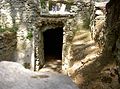
 Lučina (Grafenried) pivovarnický sklep květen 2022 (1).jpg 5,881 × 3,921; 16.87 MB
-
 Lučina (Grafenried) pivovarnický sklep květen 2022 (2).jpg 5,848 × 3,898; 10.52 MB
-
 Lučina (Grafenried) rybníček květen 2022 (1).jpg 6,000 × 4,000; 12.63 MB
-
 Lučina (Grafenried) socha na návsi květen 2022 (1).jpg 3,899 × 5,848; 19.2 MB
-
 Lučina (Grafenried) socha na návsi květen 2022 (2).jpg 3,707 × 5,560; 11.95 MB
-
 Lučina (Grafenried) státní hranice hraniční patník květen 2022 (1).jpg 6,000 × 4,000; 17.08 MB
-
 Lučina (Grafenried) státní hranice hraniční patník květen 2022 (2).jpg 4,000 × 6,000; 16.08 MB
-
 Lučina (Grafenried) státní hranice květen 2022 (1).jpg 5,969 × 3,980; 15.88 MB
-
 Lučina (Grafenried) státní hranice květen 2022 (2).jpg 5,844 × 3,896; 18.66 MB
-
 Lučina (Grafenried) státní hranice květen 2022 (3).jpg 3,916 × 5,874; 13.83 MB
-
 Lučina (Grafenried) státní hranice květen 2022 (4).jpg 3,543 × 5,315; 7.5 MB
-
 Lučina (Grafenried) státní hranice květen 2022 (5).jpg 6,000 × 4,000; 11.63 MB
-
 Lučina (Grafenried) škola květen 2022 (1).jpg 6,000 × 4,000; 17.72 MB
-
 Lučina (Grafenried) škola květen 2022 (2).jpg 5,809 × 3,873; 8.19 MB
-
 Lučina (Grafenried) škola květen 2022 (3).jpg 6,000 × 4,000; 16.98 MB
-
 Lučina (Grafenried) škola květen 2022 (4).jpg 3,699 × 5,548; 8.51 MB
-
 Lučina (Grafenried) škola květen 2022 (5).jpg 6,000 × 4,000; 14.33 MB
-
 Lučina (Grafenried) škola květen 2022 (6).jpg 6,000 × 4,000; 17.58 MB
-
 Lučina (Grafenried), 1920.jpg 3,048 × 2,113; 3.34 MB
-
 Lučina bývalý pivovarský sklep 2023.jpg 5,897 × 3,931; 9.3 MB
-
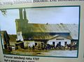
 Lučina infopanel k pivovarskému sklepu září 2023 (1).jpg 5,892 × 3,928; 6.63 MB
-
 Lučina infopanel ke kostelu září 2023 (1).jpg 5,720 × 3,813; 5.63 MB
-
 Lučina infopanel ke kostelu září 2023 (2).jpg 5,846 × 3,897; 7.91 MB
-
 Lučina infopanel ke kostelu září 2023 (3).jpg 4,000 × 6,000; 7.65 MB
-
 Lučina infopanel ke škole září 2023 (1).jpg 5,487 × 3,658; 4.44 MB
-
 Lučina infopanel ke škole září 2023 (2).jpg 5,783 × 3,856; 9.01 MB
-
 Lučina infopanel zaniklé obce září 2023 (1).jpg 5,619 × 3,746; 9.13 MB
-
 Lučina infopanely k zaniklým domům září 2023 (1).jpg 5,745 × 3,830; 6.25 MB
-
 Lučina infopanely k zaniklým domům září 2023 (10).jpg 5,819 × 3,879; 5.3 MB
-
 Lučina infopanely k zaniklým domům září 2023 (2).jpg 5,833 × 3,888; 5.92 MB
-
 Lučina infopanely k zaniklým domům září 2023 (3).jpg 5,786 × 3,857; 6.57 MB
-
 Lučina infopanely k zaniklým domům září 2023 (4).jpg 5,873 × 3,916; 5.06 MB
-
 Lučina infopanely k zaniklým domům září 2023 (5).jpg 5,804 × 3,869; 5.54 MB
-
 Lučina infopanely k zaniklým domům září 2023 (6).jpg 5,835 × 3,890; 7.54 MB
-
 Lučina infopanely k zaniklým domům září 2023 (7).jpg 5,600 × 3,733; 5.56 MB
-
 Lučina infopanely k zaniklým domům září 2023 (8).jpg 5,909 × 3,939; 5.39 MB
-
 Lučina infopanely k zaniklým domům září 2023 (9).jpg 5,799 × 3,866; 5.49 MB
-
 Lučina křížek září 2023 (1).jpg 4,000 × 6,000; 15.47 MB
-
 Lučina křížek září 2023 (2).jpg 3,905 × 5,858; 15.57 MB
-
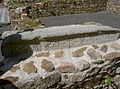
 Lučina schodiště v bývalé škole září 2023.jpg 6,000 × 4,000; 11.68 MB
-
 Lučina socha sv. Jana Nepomuckého září 2023 (1).jpg 4,000 × 6,000; 15.08 MB
-
 Lučina socha sv. Jana Nepomuckého září 2023 (2).jpg 3,878 × 5,817; 13.92 MB

.jpg)


.jpg)
.jpg)
.jpg)
.jpg)
.jpg)
.jpg)
.jpg)
.jpg)
.jpg)
.jpg)
.jpg)
.jpg)
.jpg)
.jpg)
.jpg)
.jpg)
.jpg)
.jpg)
.jpg)
.jpg)
.jpg)
.jpg)
.jpg)
.jpg)
.jpg)
.jpg)
.jpg)
.jpg)
.jpg)
.jpg)
.jpg)
.jpg)
.jpg)
.jpg)
.jpg)
.jpg)
.jpg)
.jpg)


.jpg)
.jpg)
_fara_kv%C4%9Bten_2022_(1).jpg)
_fara_kv%C4%9Bten_2022_(2).jpg)
_fara_kv%C4%9Bten_2022_(3).jpg)
_hostinec_kv%C4%9Bten_2022_(1).jpg)
_hostinec_kv%C4%9Bten_2022_(2).jpg)
_hostinec_kv%C4%9Bten_2022_(3).jpg)
_hostinec_kv%C4%9Bten_2022_(4).jpg)
_hostinec_kv%C4%9Bten_2022_(5).jpg)
_hostinec_kv%C4%9Bten_2022_(6).jpg)
_hostinec_kv%C4%9Bten_2022_(7).jpg)
_h%C5%99bitov_kv%C4%9Bten_2022_(1).jpg)
_h%C5%99bitov_kv%C4%9Bten_2022_(2).jpg)
_h%C5%99bitov_kv%C4%9Bten_2022_(3).jpg)
_h%C5%99bitov_kv%C4%9Bten_2022_(4).jpg)
_h%C5%99bitov_kv%C4%9Bten_2022_(5).jpg)
_h%C5%99bitov_kv%C4%9Bten_2022_(6).jpg)
_h%C5%99bitovn%C3%AD_kaple_kv%C4%9Bten_2022_(1).jpg)
_h%C5%99bitovn%C3%AD_kaple_kv%C4%9Bten_2022_(2).jpg)
_kv%C4%9Bten_2022_(1).jpg)
_kv%C4%9Bten_2022_(2).jpg)
_kv%C4%9Bten_2022_(3).jpg)
_kv%C4%9Bten_2022_(4).jpg)
_kv%C4%9Bten_2022_(5).jpg)
_k%C5%99%C3%AD%C5%BEek_kv%C4%9Bten_2022_(1).jpg)
_k%C5%99%C3%AD%C5%BEek_kv%C4%9Bten_2022_(2).jpg)
_pastviny_kv%C4%9Bten_2022_(1).jpg)
_pastviny_kv%C4%9Bten_2022_(2).jpg)
_pastviny_kv%C4%9Bten_2022_(3).jpg)
_pastviny_kv%C4%9Bten_2022_(4).jpg)
_pastviny_kv%C4%9Bten_2022_(5).jpg)
_pivovarnick%C3%BD_sklep_kv%C4%9Bten_2022_(1).jpg)
_pivovarnick%C3%BD_sklep_kv%C4%9Bten_2022_(2).jpg)
_rybn%C3%AD%C4%8Dek_kv%C4%9Bten_2022_(1).jpg)
_socha_na_n%C3%A1vsi_kv%C4%9Bten_2022_(1).jpg)
_socha_na_n%C3%A1vsi_kv%C4%9Bten_2022_(2).jpg)
_st%C3%A1tn%C3%AD_hranice_hrani%C4%8Dn%C3%AD_patn%C3%ADk_kv%C4%9Bten_2022_(1).jpg)
_st%C3%A1tn%C3%AD_hranice_hrani%C4%8Dn%C3%AD_patn%C3%ADk_kv%C4%9Bten_2022_(2).jpg)
_st%C3%A1tn%C3%AD_hranice_kv%C4%9Bten_2022_(1).jpg)
_st%C3%A1tn%C3%AD_hranice_kv%C4%9Bten_2022_(2).jpg)
_st%C3%A1tn%C3%AD_hranice_kv%C4%9Bten_2022_(3).jpg)
_st%C3%A1tn%C3%AD_hranice_kv%C4%9Bten_2022_(4).jpg)
_st%C3%A1tn%C3%AD_hranice_kv%C4%9Bten_2022_(5).jpg)
_%C5%A1kola_kv%C4%9Bten_2022_(1).jpg)
_%C5%A1kola_kv%C4%9Bten_2022_(2).jpg)
_%C5%A1kola_kv%C4%9Bten_2022_(3).jpg)
_%C5%A1kola_kv%C4%9Bten_2022_(4).jpg)
_%C5%A1kola_kv%C4%9Bten_2022_(5).jpg)
_%C5%A1kola_kv%C4%9Bten_2022_(6).jpg)
,_1920.jpg)

.jpg)
.jpg)
.jpg)
.jpg)
.jpg)
.jpg)
.jpg)
.jpg)
.jpg)
.jpg)
.jpg)
.jpg)
.jpg)
.jpg)
.jpg)
.jpg)
.jpg)
.jpg)
.jpg)

.jpg)
.jpg)
&filefrom=Lu%C4%8Dina+socha+sv.+Jana+Nepomuck%C3%A9ho+z%C3%A1%C5%99%C3%AD+2023+%283%29.jpg#mw-category-media)