Category:Lowndesboro, Alabama
Jump to navigation
Jump to search
|
This is a category about a place or building that is listed on the National Register of Historic Places in the United States of America. Its reference number is 73000356. |
human settlement in Lowndes County, Alabama, United States of America   | |||||
| Upload media | |||||
| Instance of | |||||
|---|---|---|---|---|---|
| Location | Lowndes County, Alabama | ||||
| Population |
| ||||
| Area |
| ||||
| Elevation above sea level |
| ||||
 | |||||
Subcategories
This category has the following 5 subcategories, out of 5 total.
Media in category "Lowndesboro, Alabama"
The following 116 files are in this category, out of 116 total.
-
 ALMap-doton-Lowndesboro.PNG 193 × 300; 14 KB
-
 DHL-House.jpg 955 × 575; 80 KB
-

-

-

-

-

-

-

-

-

-

-

-

-

-

-

-

-

-

-

-

-

-

-

-

-

-
-

-

-

-

-

-

-

-

-

-

-

-

-

-

-

-

-

-

-

-

-

-

-

-

-

-

-

-

-

-
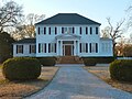 Holly House 1836 Lowndesboro Alabama Historic District.JPG 2,151 × 1,618; 1.54 MB
-

-
 Little Cottage 1830s Lowndesboro Alabama Historic District.JPG 2,816 × 2,110; 2.95 MB
-

-

-

-
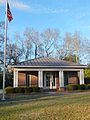 Lowndesboro Alabama Post Office 36752.JPG 2,498 × 3,333; 4.5 MB
-
 Lowndesboro Baptist Church 1888 Lowndesboro Alabama Historic District.JPG 3,244 × 4,456; 5.13 MB
-
 Lowndesboro Colored School, Lowndesboro, Alabama.jpg 1,779 × 1,729; 2.51 MB
-
 Lowndesboro First Missionary Baptist Church 1880 Lowndesboro Alabama Historic District.JPG 4,235 × 3,178; 5.27 MB
-
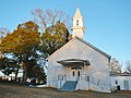
 Lowndesboro United Methodist Church 1888 Lowndesboro Alabama Historic District.JPG 3,296 × 4,492; 5.41 MB
-

-

-

-

-

-

-

-

-

-

-

-

-
 Marengo 1847 Lowndesboro Alabama Historic District.JPG 4,163 × 3,109; 4.39 MB
-
 Memorial to Viola Fauver Gregg Liuzzo, (Lowndes County, Alabama).jpg 827 × 1,024; 204 KB
-
 Memorial to Viola Fauver Gregg Liuzzo, Alabama LCCN2010638602.tif 3,835 × 4,747; 104.22 MB
-
 Memorial to Viola Fauver Gregg Liuzzo, Alabama LCCN2010638603.tif 6,144 × 4,096; 144.04 MB
-

-
-

-

-

-

-

-

-

-

-
 Rosewood House 01.jpg 942 × 668; 143 KB
-
 Rosewood House, Lowndes County, Alabama.jpg 4,195 × 2,769; 7.5 MB
-

-

-

-

-
-

-

-

-
 The Will Stone Store 1820 Lowndesboro Alabama Historic District.JPG 4,608 × 3,456; 8.15 MB
-

-

-

-

-

-

-

-

-

-

-


.jpg)

