Category:Lower Peover
Jump to navigation
Jump to search
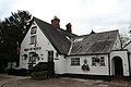
English: Lower Peover is a village in the civil parish of Nether Peover in the unitary authority of Cheshire West and Chester and the ceremonial county of Cheshire, England, approximately 6 miles east of Northwich and 4 miles south of Knutsford. The boundary of the civil parish deviates slightly to include Lower Peover in Nether Peover and not the adjacent civil parish of Peover Inferior.
village in the civil parish of Nether Peover, Cheshire East in England   | |||||
| Upload media | |||||
| Instance of | |||||
|---|---|---|---|---|---|
| Location | Peover Inferior, Cheshire East, Cheshire, North West England, England | ||||
 | |||||
Subcategories
This category has only the following subcategory.
S
Media in category "Lower Peover"
The following 31 files are in this category, out of 31 total.
-
 Bells of Peover.jpg 3,456 × 2,304; 2.48 MB
-
 Bridleway through Freegreen Farm - geograph.org.uk - 328574.jpg 640 × 474; 76 KB
-
 Bridleway to Freegreen Farm - geograph.org.uk - 328564.jpg 640 × 463; 80 KB
-
 Cobbles again - geograph.org.uk - 3162946.jpg 3,456 × 2,304; 3.45 MB
-
 Crown Lane, Lower Peover, Cheshire - geograph.org.uk - 2637100.jpg 1,600 × 1,200; 806 KB
-
 Field Boundaries - geograph.org.uk - 335734.jpg 640 × 428; 99 KB
-
 Freegreen Lane (2) - geograph.org.uk - 335720.jpg 640 × 465; 98 KB
-
 Freegreen Lane - geograph.org.uk - 335718.jpg 640 × 428; 99 KB
-
 Lower Peover view.jpg 2,518 × 1,800; 935 KB
-
 Lower Peover, Plaque on the original school building - geograph.org.uk - 6136015.jpg 6,235 × 4,157; 6.88 MB
-
 Lower Peover, Plaque on the original school building - geograph.org.uk - 6136016.jpg 5,668 × 3,779; 5.62 MB
-
 Lower Peover, Weather vane on the original school building - geograph.org.uk - 6136018.jpg 6,809 × 4,539; 2.82 MB
-
 Old School House, Lower Peover.jpg 1,600 × 1,200; 515 KB
-
 Primary School - geograph.org.uk - 6127243.jpg 4,692 × 3,097; 4.42 MB
-
 Schoolhouse at Lower Peover.jpg 4,000 × 3,000; 1.18 MB
-
 The Bells of Peover - geograph.org.uk - 86472.jpg 640 × 479; 142 KB
-
 The Cobbles, Lower Peover - geograph.org.uk - 3162858.jpg 3,456 × 2,304; 3.19 MB
-
 The Mill House - geograph.org.uk - 3162971.jpg 3,408 × 2,001; 2.63 MB
-
 The weir with footbridge - geograph.org.uk - 3163009.jpg 2,304 × 3,456; 2.46 MB
-
 Large Puddle... - geograph.org.uk - 335728.jpg 640 × 343; 98 KB
-
 Letter Box - geograph.org.uk - 335750.jpg 640 × 428; 100 KB
-
 Mill Lane - geograph.org.uk - 335747.jpg 640 × 356; 97 KB
-
 Noticeboard and Sign - geograph.org.uk - 335741.jpg 640 × 580; 97 KB
-
 Pasture Land - geograph.org.uk - 335721.jpg 640 × 377; 98 KB
-
 Path across the fields, Lower Peover - geograph.org.uk - 293042.jpg 640 × 480; 110 KB
-
 Peover Superior Parish - geograph.org.uk - 335727.jpg 640 × 298; 97 KB
-
 Sign to Grasslands Nursery - geograph.org.uk - 335716.jpg 640 × 442; 89 KB
-
 Stile and Fallen Tree - geograph.org.uk - 335731.jpg 428 × 640; 100 KB
-
 Stile, Gate and Footpath - geograph.org.uk - 328558.jpg 640 × 428; 85 KB
-
 The Road away from Hucknall Farm - geograph.org.uk - 328580.jpg 640 × 451; 64 KB
-
 The Road to Hucknall Farm - geograph.org.uk - 328570.jpg 640 × 462; 73 KB


_-_geograph.org.uk_-_335720.jpg)


