Category:Lower Langford
Jump to navigation
Jump to search
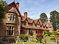
English: Lower Langford is a village in the unitary authority of North Somerset, England. It is located on the western edge of the Mendip Hills about east of Weston-super-Mare. It was a village built around the estate of Sidney Hill who was the original inhabitant of the village
village in United Kingdom  | |||||
| Upload media | |||||
| Instance of | |||||
|---|---|---|---|---|---|
| Location | Churchill, North Somerset, Somerset, South West England, England | ||||
 | |||||
Subcategories
This category has the following 2 subcategories, out of 2 total.
L
M
- St Mary's Church, Langford (11 F)
Media in category "Lower Langford"
The following 14 files are in this category, out of 14 total.
-
 Alpacas graze in the hamlet of Stock - geograph.org.uk - 99216.jpg 640 × 480; 132 KB
-
 Langford Estate.jpg 4,032 × 3,024; 4.48 MB
-
 Langford House Lower Langford.jpg 2,119 × 1,044; 529 KB
-
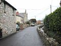 Lower Langford.jpg 640 × 480; 99 KB
-
 Victoria Jubilee Langford Homes - geograph.org.uk - 99221.jpg 640 × 480; 153 KB
-
 Victoria Jubilee Langford Homes.jpg 4,032 × 3,024; 5.4 MB
-
 Blagdon Water Gardens - geograph.org.uk - 74476.jpg 640 × 426; 134 KB
-
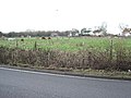
 Field and pumping station, Blackmoor - geograph.org.uk - 426028.jpg 640 × 480; 139 KB
-
 Free Range Chickens - geograph.org.uk - 74471.jpg 640 × 426; 114 KB
-
 Junction for Brinsea Milk Farm - geograph.org.uk - 109857.jpg 640 × 426; 149 KB
-
 Lay-by on the A38 - geograph.org.uk - 85082.jpg 640 × 480; 77 KB
-

-

-


