Category:Lourdesgrot (Luttenberg)
Jump to navigation
Jump to search
| Object location | | View all coordinates using: OpenStreetMap |
|---|
cave in the Netherlands  | |||||
| Upload media | |||||
| Instance of | |||||
|---|---|---|---|---|---|
| Dedicated to | |||||
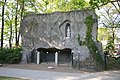
| Location | Luttenberg, Raalte, Overijssel, Netherlands | ||||
| Street address |
| ||||
| Heritage designation |
| ||||
 | |||||
|
This is a category about rijksmonument number 513678
|
| Address |
|
Nederlands: Lourdesgrotten: Overzicht Lourdesgrot (opmerking: Gefotografeerd voor Monumenten In Nederland Overijssel)
Media in category "Lourdesgrot (Luttenberg)"
The following 3 files are in this category, out of 3 total.
-
 Luttenberg-Mariagrot.JPG 3,888 × 2,592; 6.03 MB
-
 Overzicht Lourdesgrot - Luttenberg - 20351116 - RCE.jpg 1,200 × 1,197; 454 KB
-
 Overzicht Lourdesgrot - Luttenberg - 20351350 - RCE.jpg 1,185 × 1,200; 458 KB

