Category:Loon 7, Waalre
Jump to navigation
Jump to search
| Object location | | View all coordinates using: OpenStreetMap |
|---|
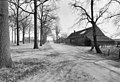
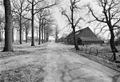
farmhouse in Waalre, Netherlands  | |||||
| Upload media | |||||
| Instance of | |||||
|---|---|---|---|---|---|
| Location | Waalre-dorp, Waalre, North Brabant, Netherlands | ||||
| Street address |
| ||||
| Heritage designation |
| ||||
 | |||||
|
This is a category about rijksmonument number 38191
|
| Address |
|
Media in category "Loon 7, Waalre"
The following 15 files are in this category, out of 15 total.
-
 Aanzicht - Loon - 20142186 - RCE.jpg 1,200 × 805; 241 KB
-
 Achtergevel - Loon - 20142193 - RCE.jpg 1,200 × 1,200; 448 KB
-
 Erf - Loon - 20460228 - RCE.jpg 1,200 × 900; 137 KB
-
 Kop- en zijgevel - Loon - 20460227 - RCE.jpg 1,200 × 900; 186 KB
-
 Kop- en zijgevel - Loon - 20460229 - RCE.jpg 1,200 × 900; 184 KB
-
 Linkerzijgevel - Loon - 20142192 - RCE.jpg 1,197 × 1,200; 472 KB
-
 Linkerzijgevel en voorgevel - Loon - 20142182 - RCE.jpg 1,200 × 960; 371 KB
-
 Monument 38191, Loon 7 Waalre.jpg 4,320 × 3,240; 5.58 MB
-
 Overzicht - Loon - 20142187 - RCE.jpg 1,200 × 820; 317 KB
-
 Overzicht - Loon - 20142188 - RCE.jpg 1,200 × 820; 324 KB
-
 Overzicht - Loon - 20142189 - RCE.jpg 1,200 × 823; 329 KB
-
 Rechter zijgevel - Loon - 20142191 - RCE.jpg 1,186 × 1,200; 344 KB
-
 Voorgevel - Loon - 20142180 - RCE.jpg 1,200 × 968; 353 KB
-
 Voorgevel - Loon - 20142181 - RCE.jpg 1,200 × 953; 313 KB
-
 Voorgevel - Loon - 20142190 - RCE.jpg 1,190 × 1,200; 362 KB


