Category:Long Tom, St Cleer
Jump to navigation
Jump to search
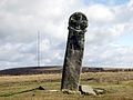
wayside cross in St Cleer, Cornwall, England, UK  | |||||
| Upload media | |||||
| Instance of | |||||
|---|---|---|---|---|---|
| Location | St Cleer, Cornwall, South West England, England | ||||
| Heritage designation |
| ||||
 | |||||
|
This is a category about scheduled monument number 1011901. |
English: Also known as the "Longstone" or the "Longstone Cross."
Media in category "Long Tom, St Cleer"
The following 8 files are in this category, out of 8 total.
-
 Long Tom - geograph.org.uk - 816.jpg 640 × 480; 116 KB
-
 Longstone or Long Tom - geograph.org.uk - 2874373.jpg 3,040 × 2,288; 3.1 MB
-
 The Longstone - geograph.org.uk - 955450.jpg 640 × 480; 67 KB
-
 The Longstone - geograph.org.uk - 955457.jpg 480 × 640; 86 KB
-
 The Longstone Bodmin Moor Cornwall.jpg 3,040 × 2,288; 1.42 MB
-
 The Longstone Cross (known as Long Tom) - geograph.org.uk - 3382430.jpg 1,024 × 768; 80 KB
-
 The Longstone or Long Tom - geograph.org.uk - 3995624.jpg 4,000 × 3,000; 2.71 MB
-
 The Longstone, Minions - geograph.org.uk - 4655718.jpg 1,600 × 1,200; 392 KB


_-_geograph.org.uk_-_3382430.jpg)

