Category:Loker Churchyard, Commonwealth Plots
Jump to navigation
Jump to search
 | |||||
| Upload media | |||||
| Instance of | |||||
|---|---|---|---|---|---|
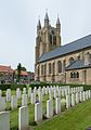
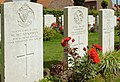
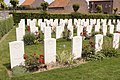
| Location | Loker, Heuvelland, Arrondissement of Ypres, West Flanders, Flemish Region, Belgium | ||||
| Heritage designation |
| ||||
| Quantity buried |
| ||||
 | |||||
Media in category "Loker Churchyard, Commonwealth Plots"
The following 25 files are in this category, out of 25 total.
-
 Loker Churchyard, Commonwealth Plots 2023.jpg 4,896 × 3,672; 7.48 MB
-
 Loker Churchyard, perk I - 2764 - onroerenderfgoed.jpg 640 × 480; 95 KB
-
 Loker Churchyard, perk II - 2763 - onroerenderfgoed.jpg 640 × 480; 91 KB
-
 Loker Churchyard, registerkastje - 2765 - onroerenderfgoed.jpg 480 × 640; 95 KB
-
 Loker Churchyard-1-2.jpg 2,303 × 1,542; 3.89 MB
-
 Loker Churchyard-10-2.jpg 1,945 × 1,301; 2.89 MB
-
 Loker Churchyard-11.jpg 1,945 × 1,359; 2.51 MB
-
 Loker Churchyard-12.jpg 1,945 × 1,255; 2.44 MB
-
 Loker Churchyard-13.jpg 1,945 × 1,375; 2.53 MB
-
 Loker Churchyard-14.jpg 1,400 × 1,945; 2.31 MB
-
 Loker Churchyard-15.jpg 1,945 × 1,417; 2.46 MB
-
 Loker Churchyard-16.jpg 1,945 × 1,501; 2.55 MB
-
 Loker Churchyard-17.jpg 1,303 × 1,945; 2.09 MB
-
 Loker Churchyard-18.jpg 1,356 × 1,945; 1.8 MB
-
 Loker Churchyard-2-3.jpg 1,945 × 1,375; 2.69 MB
-
 Loker Churchyard-3-2.jpg 1,945 × 1,296; 2.74 MB
-
 Loker Churchyard-4-2.jpg 1,945 × 1,296; 3.04 MB
-
 Loker Churchyard-5-2.jpg 1,945 × 1,334; 2.49 MB
-
 Loker Churchyard-9-2.jpg 1,945 × 1,317; 2.97 MB
-
 Loker Churchyard.10 1.JPG 3,456 × 2,304; 4.78 MB
-
 Loker Churchyard.2 1.JPG 3,278 × 2,185; 5.43 MB
-
 Loker Churchyard.5 1.JPG 3,276 × 2,185; 4.54 MB
-
 Loker Churchyard.6.jpg 3,456 × 2,304; 2.28 MB
-
 Loker Churchyard.7.jpg 3,456 × 2,304; 2.77 MB
-
 Loker Churchyard.8 1.JPG 3,456 × 2,304; 4.79 MB


