
Category:Loerbeek
| Object location | | View all coordinates using: OpenStreetMap |
|---|
village in Montferland, Netherlands   | |||||
| Upload media | |||||
| Spoken text audio | |||||
|---|---|---|---|---|---|
| Instance of | |||||
| Location | Montferland, Gelderland, Netherlands | ||||
 | |||||
Subcategories
This category has the following 2 subcategories, out of 2 total.
M
- Molen van Berntsen (9 F)
Media in category "Loerbeek"
The following 24 files are in this category, out of 24 total.
-
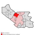
 Map - NL - Montferland - Wijk 01 Brakel - Buurt 02 Loerbeek.svg 375 × 375; 29 KB
-
-
Nl-Loerbeek-article.ogg 1 min 50 s; 1.06 MB
-
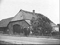 Achter- en zijgevel - Loerbeek - 20467062 - RCE.jpg 1,200 × 900; 179 KB
-
 Achter- en zijgevel nieuwe woning nr. 553-11 - Loerbeek - 20501899 - RCE.jpg 1,200 × 900; 175 KB
-
 Achtergevel - Loerbeek - 20467060 - RCE.jpg 1,200 × 900; 190 KB
-
 Achtergevel - Loerbeek - 20494827 - RCE.jpg 1,200 × 900; 134 KB
-
 Loerbeek-haspelweg-185168.jpg 3,264 × 2,448; 2.91 MB
-
 Montferland Loerbeek Doetinchemseweg 37 PM19-01.jpg 4,896 × 3,672; 5.14 MB
-
 Montferland Loerbeek Doetinchemseweg trafohuisje PM19-01.jpg 4,896 × 3,672; 5.91 MB
-
 Montferland Loerbeek Doetinchemseweg trafohuisje PM19-02.jpg 4,896 × 3,672; 7.05 MB
-
 Montferland Loerbeek Doetinchemseweg trafohuisje PM19-03.jpg 4,834 × 3,608; 5.16 MB
-
 Montferland Loerbeek Komperwijkweg trafohuisje PM19-01.jpg 4,896 × 3,672; 7.45 MB
-
 Voor- en zijgevel - Loerbeek - 20467061 - RCE.jpg 1,200 × 900; 154 KB
-
 Voor- en zijgevel - Loerbeek - 20467063 - RCE.jpg 1,200 × 900; 169 KB
-
 Voor- en zijgevel - Loerbeek - 20494828 - RCE.jpg 1,200 × 900; 210 KB
-
 Voor- en zijgevel nr. 551-12 - Loerbeek - 20501901 - RCE.jpg 1,200 × 900; 217 KB
-
 Voor- en zijgevel nr. 553-10 - Loerbeek - 20501898 - RCE.jpg 1,200 × 900; 180 KB
-
 Voorgevel nr. 553-8 - Loerbeek - 20501897 - RCE.jpg 1,200 × 900; 194 KB
-
 Zij- en kopgevel - Loerbeek - 20494826 - RCE.jpg 1,200 × 900; 195 KB
-
 Zij- en voorgevel - Loerbeek - 20467059 - RCE.jpg 1,200 × 900; 184 KB
-
 Zij- en voorgevel 551-10 - Loerbeek - 20501900 - RCE.jpg 1,200 × 900; 183 KB
-
 Zij- en voorgevel nr. 553-13 - Loerbeek - 20501896 - RCE.jpg 1,200 × 900; 213 KB
-
 Zij- en voorgevel nr. 553-7 - Loerbeek - 20501895 - RCE.jpg 1,200 × 900; 194 KB


