Category:Loenenseweg 4, Vreeland
Jump to navigation
Jump to search
| Object location | | View all coordinates using: OpenStreetMap |
|---|
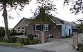
farmhouse in Stichtse Vecht, Netherlands  | |||||
| Upload media | |||||
| Instance of | |||||
|---|---|---|---|---|---|
| Location | Vreeland, Utrecht, Netherlands | ||||
| Street address |
| ||||
| Located on street |
| ||||
| Heritage designation |
| ||||
 | |||||
|
This is a category about rijksmonument number 26148
|
| Address |
|
Media in category "Loenenseweg 4, Vreeland"
The following 9 files are in this category, out of 9 total.
-
 Aanzicht - Vreeland - 20247232 - RCE.jpg 1,200 × 813; 303 KB
-
 Aanzicht - Vreeland - 20247233 - RCE.jpg 1,200 × 808; 279 KB
-
 Aanzicht achterzijde - Vreeland - 20247237 - RCE.jpg 1,200 × 791; 293 KB
-
 Achterzijde - Vreeland - 20247238 - RCE.jpg 1,200 × 802; 214 KB
-
 Voor en rechter zijgevel - Vreeland - 20247235 - RCE.jpg 1,200 × 793; 303 KB
-
 Voor- en rechter zijgevel - Vreeland - 20247236 - RCE.jpg 1,200 × 796; 249 KB
-
 Vooraanzicht - Vreeland - 20247234 - RCE.jpg 1,200 × 800; 289 KB
-
 Vooraanzicht - Vreeland - 20247239 - RCE.jpg 1,200 × 793; 225 KB
-
 Vreeland - Loenenseweg 4 RM26148.JPG 4,362 × 2,740; 1.39 MB


