Category:Loen kyrkje
Jump to navigation
Jump to search
| Object location | | View all coordinates using: OpenStreetMap |
|---|
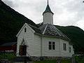
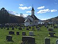
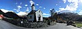
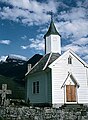
Parish church in Loen, Stryn municipality, Norway  Loen kirke | |||||
| Upload media | |||||
| Instance of | |||||
|---|---|---|---|---|---|
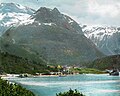
| Location | Loen, Stryn Municipality, Vestland, Norway | ||||
| Diocese | |||||
| Heritage designation | |||||
| Inception |
| ||||
 | |||||
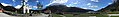
Media in category "Loen kyrkje"
The following 20 files are in this category, out of 20 total.
-
 Kirche von Loen.jpg 2,827 × 1,636; 1.3 MB
-
 Kirche von Loen Norwegen.JPG 1,200 × 900; 113 KB
-
 Loen - SFFf-1992078.0058 (3613851668).jpg 4,752 × 3,789; 2.58 MB
-
 Loen Church Sogn og Fjordane 01 2015-04-28.JPG 3,264 × 2,448; 2.56 MB
-
 Loen Church Sogn og Fjordane 02 2015-04-28.JPG 3,264 × 2,448; 2.46 MB
-
 Loen Church Sogn og Fjordane 03 2015-04-28.JPG 3,264 × 2,448; 2.53 MB
-
 Loen Church Sogn og Fjordane 04 2015-04-28.JPG 3,264 × 2,448; 2.4 MB
-
 Loen Church Sogn og Fjordane 05 evening 2015-04-28.JPG 3,264 × 2,448; 1.97 MB
-
 Loen Church Sogn og Fjordane 06 graveyard 2015-04-28.JPG 3,264 × 2,448; 2.2 MB
-
 Loen Church Sogn og Fjordane Panorama01 2015-04-28.JPG 10,581 × 2,329; 8.69 MB
-
 Loen Church Sogn og Fjordane Panorama02 2015-04-28.JPG 9,058 × 2,354; 9.07 MB
-
 Loen Church Sogn og Fjordane Panorama03 2015-04-28.JPG 6,201 × 2,219; 5.17 MB
-
 Loen Church Sogn og Fjordane Panorama04 Memorial 2015-04-28.JPG 10,800 × 2,350; 8.87 MB
-
 Loen church.jpg 2,848 × 2,136; 1.61 MB
-
 Loen kirke - an10071206041001.jpg 6,349 × 4,392; 16.13 MB
-
 Loen kirke.jpg 640 × 470; 138 KB
-
 Loen med kyrkja.jpg 2,848 × 2,136; 1.53 MB
-
 N74Loen01.jpg 1,219 × 1,666; 410 KB
-
 Stone cross Loen.jpg 2,848 × 2,136; 1.57 MB
-
 Wv Loen banner.JPG 10,581 × 1,512; 6.05 MB


.jpg)


