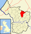
Category:Lockleaze (ward)
Jump to navigation
Jump to search
electoral ward of the unitary authority of Bristol | |||||
| Upload media | |||||
| Instance of |
| ||||
|---|---|---|---|---|---|
| Location | City of Bristol, South West England, England | ||||
| Different from | |||||
| |||||
Subcategories
This category has the following 4 subcategories, out of 4 total.
Media in category "Lockleaze (ward)"
The following 59 files are in this category, out of 59 total.
-
2011 , St.James Church, Lockleaze, Bristol - geograph.org.uk - 2407868.jpg 4,400 × 2,923; 4.81 MB
-
Across Boiling Wells - geograph.org.uk - 6619698.jpg 3,648 × 1,744; 1.77 MB
-
Across the railway line, Ashley Vale - geograph.org.uk - 6369429.jpg 3,005 × 1,612; 687 KB
-
Bargain Booze Plus on Filton Road, Horfield - geograph.org.uk - 6175714.jpg 1,920 × 1,280; 1.42 MB
-
Beatrix Place - geograph.org.uk - 5760717.jpg 4,288 × 2,848; 980 KB
-
Block of flats on Filton Road, Northville - geograph.org.uk - 6175722.jpg 1,868 × 1,200; 1.07 MB
-
Bonnington Walk, Lockleaze - geograph.org.uk - 6022139.jpg 5,202 × 3,465; 2.61 MB
-
Bristol lockleaze.png 702 × 780; 148 KB
-
Bristol M32 Motorway 01.jpg 480 × 556; 68 KB
-
Bristol MMB «D2 Narroways Hill.jpg 2,954 × 1,961; 2.52 MB
-
City Farm Boiling Wells Project - geograph.org.uk - 6046129.jpg 4,179 × 2,977; 2.54 MB
-
Cycle and footpath from Muller Road - geograph.org.uk - 6045831.jpg 4,288 × 3,216; 7.32 MB
-
Dower House - geograph.org.uk - 5895025.jpg 2,048 × 1,536; 874 KB
-
Dower House - geograph.org.uk - 6169123.jpg 2,798 × 2,010; 2.06 MB
-
Dower House - geograph.org.uk - 6499574.jpg 1,488 × 1,382; 680 KB
-
Dower House and Duchess Pond in Stoke Park, Bristol, England 30Sept2014 arp.jpg 3,951 × 2,963; 3.38 MB
-
Dulcie Mary Pillers Place, Lockleaze, Bristol.jpg 2,845 × 3,167; 3.09 MB
-
Ennywevers Campsite, Boiling Well's Lane - geograph.org.uk - 6046114.jpg 4,288 × 3,216; 7.18 MB
-
Europcar on Muller Road, Horfield - geograph.org.uk - 6174172.jpg 1,892 × 1,236; 1.22 MB
-
Europcar on Muller Road, Horfield - geograph.org.uk - 6174173.jpg 1,848 × 1,162; 1.08 MB
-
Filton Avenue - geograph.org.uk - 5760713.jpg 4,288 × 2,848; 2.02 MB
-
Filton Road, Horfield - geograph.org.uk - 6174170.jpg 1,824 × 1,114; 1,020 KB
-
Flat Rooves in Romney Avenue - geograph.org.uk - 5895030.jpg 2,048 × 1,536; 988 KB
-
Footbridge on the edge of Ikea land - geograph.org.uk - 5973643.jpg 640 × 363; 143 KB
-
Gainsborough Square, Lockleaze, looking southeastwards - geograph.org.uk - 6022147.jpg 5,202 × 3,465; 2.82 MB
-
Gainsborough Square, Lockleaze. Looking southwards. - geograph.org.uk - 6022143.jpg 5,202 × 3,465; 2.85 MB
-
Lockleaze Bristol UK ward map.svg 1,138 × 1,266; 709 KB
-
Lockleaze Buzz, Gainsborough Square - geograph.org.uk - 6022150.jpg 3,257 × 3,465; 1.61 MB
-
Lockleaze Sports Centre - geograph.org.uk - 6022136.jpg 5,202 × 3,465; 2.38 MB
-
M32 motorway seen from Stoke Park, Bristol, England 30Sept2014 arp.jpg 3,905 × 2,929; 3.81 MB
-
M32 northbound at Eastville - geograph.org.uk - 6408146.jpg 800 × 601; 96 KB
-
M32 passing under Heath House Lane - geograph.org.uk - 6408153.jpg 800 × 600; 87 KB
-
M32 underpass - geograph.org.uk - 6499571.jpg 4,896 × 3,264; 5.99 MB
-
Muller Road. Eastville - geograph.org.uk - 6174174.jpg 1,890 × 1,234; 1.08 MB
-
Muller Road. Eastville - geograph.org.uk - 6175728.jpg 1,822 × 1,120; 969 KB
-
Narroways Jct 158 snow.jpg 800 × 1,195; 768 KB
-
Outside Tesco Extra - geograph.org.uk - 5579511.jpg 6,000 × 4,000; 4.38 MB
-
Path in Stoke Park - geograph.org.uk - 5895013.jpg 2,048 × 1,536; 1,001 KB
-
Pur Down Communications Tower - geograph.org.uk - 5721169.jpg 480 × 640; 53 KB
-
Pur Down Obelisk - geograph.org.uk - 1447514.jpg 640 × 480; 66 KB
-
Purdown Open Space - geograph.org.uk - 6045824.jpg 4,288 × 3,216; 5.18 MB
-
Raja Rammohun Roy Walk - geograph.org.uk - 5693207.jpg 640 × 480; 94 KB
-
River Frome - geograph.org.uk - 5693219.jpg 640 × 480; 128 KB
-
Scrub clearance on Pur Down - geograph.org.uk - 5895018.jpg 2,048 × 1,536; 1.19 MB
-
Shakespeare Avenue - geograph.org.uk - 5760724.jpg 4,288 × 2,848; 1.46 MB
-
Shops at centre of Lockleaze - geograph.org.uk - 5895034.jpg 2,048 × 1,536; 1.17 MB
-
Shops on Filton Avenue - geograph.org.uk - 5760733.jpg 3,984 × 2,096; 586 KB
-
St John's Lane Allotments - geograph.org.uk - 5895007.jpg 1,536 × 2,048; 1.17 MB
-
Stapleton Road - geograph.org.uk - 6494896.jpg 3,705 × 2,638; 2.66 MB
-
Stoke Park Primary School - geograph.org.uk - 5721156.jpg 640 × 480; 45 KB
-
Tesco Extra Eastgate Road - geograph.org.uk - 5579516.jpg 5,604 × 3,816; 3.6 MB
-
The Dower House, Stoke Park - geograph.org.uk - 5579531.jpg 5,406 × 3,604; 4.5 MB
-
The Old Library, Muller Road - geograph.org.uk - 6042798.jpg 3,964 × 2,973; 2.17 MB
-
Thistles and Teasels - geograph.org.uk - 5895022.jpg 2,048 × 1,536; 1.44 MB
-
Train 2 mar 09 - Flickr - Greater Bristol Metro Rail.jpg 1,024 × 683; 612 KB
-
Train mar 09 - Flickr - Greater Bristol Metro Rail.jpg 1,024 × 683; 574 KB
-
Tunnel on Boiling Wells Lane - geograph.org.uk - 6042749.jpg 4,288 × 3,216; 7.47 MB
-
Unexpected cattle - geograph.org.uk - 6046100.jpg 4,288 × 3,216; 6.67 MB


