Category:Locator maps of subdivisions of British India
Jump to navigation
Jump to search
Media in category "Locator maps of subdivisions of British India"
The following 16 files are in this category, out of 16 total.
-
 Amb in North-West Frontier States Agency in British India 1940.png 1,621 × 1,469; 98 KB
-
 Baluchistan Agency in British India 1940.png 1,621 × 1,469; 100 KB
-
 Benares State in British India 1940.png 1,621 × 1,469; 85 KB
-
 Dir in North-West Frontier States Agency in British India 1940.png 1,621 × 1,469; 97 KB
-
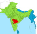 Hyderabad State in British India 1940.png 1,621 × 1,469; 86 KB
-
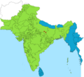
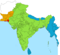
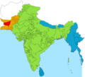
 Jammu and Kashmir (princely state) in British India 1940.png 1,621 × 1,469; 85 KB
-
 Khanate of Kalat in British India 1940.png 1,621 × 1,469; 86 KB
-
 Kingdom of Phulra in North-West Frontier States Agency in British India 1940.png 1,621 × 1,469; 98 KB
-
 Kingdom of Travancore State in British India 1940.png 1,621 × 1,469; 85 KB
-
 Las Bela (princely state) in British India 1940.png 1,621 × 1,469; 86 KB
-
 Makran (princely state) in British India 1940.png 1,621 × 1,469; 86 KB
-
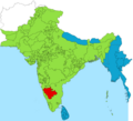 Mysore State in British India 1940.png 1,621 × 1,469; 85 KB
-
 North-West Frontier States Agency in British India 1940.png 1,621 × 1,469; 98 KB
-
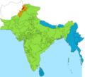
 State of Chitral in North-West Frontier States Agency in British India 1940.png 1,621 × 1,469; 97 KB
-
 State of Kharan in British India 1940.png 1,621 × 1,469; 86 KB
-
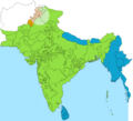
 State of Swat in North-West Frontier States Agency in British India 1940.png 1,621 × 1,469; 97 KB


_in_British_India_1940.png)


_in_British_India_1940.png)
_in_British_India_1940.png)


