Category:Locator maps of populated places in Kerala
Jump to navigation
Jump to search
States of India: Andhra Pradesh · Karnataka · Kerala · Maharashtra ·
Union territories:
Former states of India:
Former union territories:
Union territories:
Former states of India:
Former union territories:
Subcategories
This category has only the following subcategory.
L
Media in category "Locator maps of populated places in Kerala"
The following 15 files are in this category, out of 15 total.
-
 Chittilamchery.jpg 364 × 282; 34 KB
-
 Kerala Political map.png 1,793 × 2,170; 243 KB
-
 Kozhikode locator.png 239 × 290; 32 KB
-
 Kozhuvanal.jpg 384 × 384; 40 KB
-
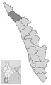 Location of Kannur Kerala.png 251 × 420; 9 KB
-
 Location of Kochi Kerala.png 251 × 420; 9 KB
-
 Location of Kollam Kerala.png 251 × 420; 9 KB
-
 Location of Kottayam Kerala.png 251 × 420; 9 KB
-
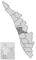
 Location of Kozhikode Kerala.png 251 × 420; 9 KB
-
 Location of Malappuram Kerala.png 251 × 420; 9 KB
-
 Location of Palakkad Kerala.png 251 × 420; 9 KB
-
 Location of Thrissur Kerala.png 251 × 420; 9 KB
-
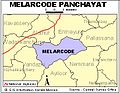
 Manakkaattumap.png 240 × 350; 35 KB
-
 Maverikala map.GIF 579 × 705; 85 KB
-
 Neeleswaram.svg 840 × 656; 808 KB


