Category:Locator maps of parliamentary constituencies of Northern Ireland
Jump to navigation
Jump to search
Maps of Parliamentary constituencies in Northern Ireland. Apart from the Bannside NI parliament map (historic), all the other maps here have been out of date since the 2010 election!
Subcategories
This category has the following 2 subcategories, out of 2 total.
Media in category "Locator maps of parliamentary constituencies of Northern Ireland"
The following 21 files are in this category, out of 21 total.
-
 Bannside (Northern Ireland Parliament constituency).svg 683 × 559; 153 KB
-
 EastAntrimConstituency.svg 779 × 635; 135 KB
-
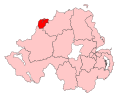
 EastLondonderryConstituency.svg 779 × 635; 135 KB
-
 FermanaghSouthTyroneConstituency.svg 779 × 635; 135 KB
-
 FoyleConstituency.svg 779 × 635; 135 KB
-
 Irish Constituencies 1885 - North Antrim.svg 675 × 895; 45 KB
-
 Irish parliamentary constituencies 1885 - 1922 North Antrim.svg 675 × 895; 91 KB
-
 LaganValleyConstituency.svg 779 × 635; 135 KB
-
 MidUlsterConstituency.svg 779 × 635; 135 KB
-
 NewryArmaghConstituency.svg 779 × 635; 135 KB
-
 NI Parliamentary Constituencies 2024.svg 512 × 384; 242 KB
-
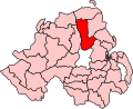
 NorthAntrimConstituency.svg 779 × 635; 135 KB
-
 NorthDownConstituency.svg 779 × 635; 135 KB
-
 NorthernIreland2023Constituencies.svg 512 × 410; 213 KB
-
 NorthernIrelandParliamentaryConstituenciesNumbered.svg 280 × 225; 105 KB
-
 SouthAntrimConstituency.svg 779 × 635; 135 KB
-
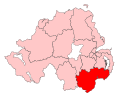 SouthDownConstituency.svg 779 × 635; 135 KB
-
 StrangfordConstituency.svg 779 × 635; 135 KB
-
 UpperBannConstituency.svg 779 × 635; 135 KB
-
 Wahlkreise Nordirland.svg 664 × 639; 206 KB
-
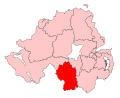
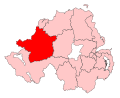 WestTyroneConstituency.svg 779 × 635; 135 KB
.svg)


