Category:Locator maps of parliamentary constituencies of Dorset
Jump to navigation
Jump to search
Maps of Parliamentary constituencies in Dorset.
Media in category "Locator maps of parliamentary constituencies of Dorset"
The following 18 files are in this category, out of 18 total.
-
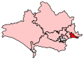 BournemouthEast2007Constituency.svg 209 × 149; 116 KB
-
 BournemouthEastConstituency.svg 200 × 140; 12 KB
-
 BournemouthWest2007Constituency.svg 209 × 149; 116 KB
-
 BournemouthWestConstituency.svg 200 × 140; 12 KB
-
 Christchurch2007Constituency.svg 209 × 149; 116 KB
-
 ChristchurchConstituency.svg 200 × 140; 12 KB
-
 DorsetParliamentaryConstituencies2007.svg 209 × 149; 75 KB
-
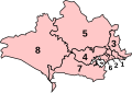 DorsetParliamentaryConstituenciesNumbered.svg 200 × 140; 16 KB
-
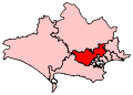 MidDorsetNorthPoole2007Constituency.svg 209 × 149; 116 KB
-
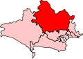
 MidDorsetNorthPooleConstituency.svg 200 × 140; 12 KB
-
 NorthDorset2007Constituency.svg 209 × 149; 116 KB
-
 NorthDorsetConstituency.svg 200 × 140; 12 KB
-
 Poole2007Constituency.svg 209 × 149; 116 KB
-
 PooleConstituency.svg 200 × 140; 12 KB
-
 SouthDorset2007Constituency.svg 209 × 149; 116 KB
-
 SouthDorsetConstituency.svg 200 × 140; 12 KB
-
 WestDorset2007Constituency.svg 209 × 149; 116 KB
-
 WestDorsetConstituency.svg 200 × 140; 12 KB


