Category:Locator maps of neighborhoods in Westland
Jump to navigation
Jump to search
Media in category "Locator maps of neighborhoods in Westland"
The following 108 files are in this category, out of 108 total.
-

-
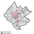 Map - NL - Westland - Wijk 01 Naaldwijk - Buurt 02 Galgeblok.svg 375 × 375; 46 KB
-
 Map - NL - Westland - Wijk 01 Naaldwijk - Buurt 03 Opstal.svg 375 × 375; 46 KB
-
 Map - NL - Westland - Wijk 01 Naaldwijk - Buurt 04 De Geest.svg 375 × 375; 46 KB
-
 Map - NL - Westland - Wijk 01 Naaldwijk - Buurt 05 Lage Woerd.svg 375 × 375; 46 KB
-
 Map - NL - Westland - Wijk 01 Naaldwijk - Buurt 06 Midden Woerd.svg 375 × 375; 46 KB
-
 Map - NL - Westland - Wijk 01 Naaldwijk - Buurt 07 Dijkweg.svg 375 × 375; 46 KB
-
 Map - NL - Westland - Wijk 01 Naaldwijk - Buurt 08 Stokdijkhof.svg 375 × 375; 46 KB
-

-
 Map - NL - Westland - Wijk 01 Naaldwijk - Buurt 10 Bloemenbuurt.svg 375 × 375; 46 KB
-
 Map - NL - Westland - Wijk 01 Naaldwijk - Buurt 11 Kruisbroek.svg 375 × 375; 46 KB
-
 Map - NL - Westland - Wijk 01 Naaldwijk - Buurt 12 Tiendweg.svg 375 × 375; 46 KB
-
-
-
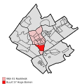
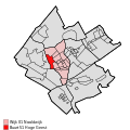 Map - NL - Westland - Wijk 01 Naaldwijk - Buurt 51 Hoge Geest.svg 375 × 375; 46 KB
-
 Map - NL - Westland - Wijk 01 Naaldwijk - Buurt 52 Woerdblok.svg 375 × 375; 46 KB
-
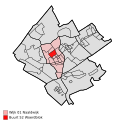
 Map - NL - Westland - Wijk 01 Naaldwijk - Buurt 53 Weeswoning.svg 375 × 375; 46 KB
-

-
 Map - NL - Westland - Wijk 01 Naaldwijk - Buurt 55 Hoge Woerd.svg 375 × 375; 46 KB
-
 Map - NL - Westland - Wijk 01 Naaldwijk - Buurt 56 Bospolder.svg 375 × 375; 46 KB
-
 Map - NL - Westland - Wijk 01 Naaldwijk - Buurt 57 Hoge Bomen.svg 375 × 375; 46 KB
-
 Map - NL - Westland - Wijk 01 Naaldwijk - Buurt 58 Heimont.svg 375 × 375; 46 KB
-
 Map - NL - Westland - Wijk 01 Naaldwijk.svg 625 × 575; 11 KB
-

-
 Map - NL - Westland - Wijk 02 Honselersdijk - Buurt 02 Nederhof.svg 375 × 375; 46 KB
-

-
 Map - NL - Westland - Wijk 02 Honselersdijk - Buurt 04 Symfonia.svg 375 × 375; 46 KB
-

-

-

-

-
-

-

-

-
 Map - NL - Westland - Wijk 02 Honselersdijk - Buurt 52 Rolpaal.svg 375 × 375; 46 KB
-

-

-

-
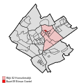
 Map - NL - Westland - Wijk 02 Honselersdijk - Buurt 56 Veiling.svg 375 × 375; 46 KB
-
-

-

-
 Map - NL - Westland - Wijk 02 Honselersdijk.svg 625 × 575; 11 KB
-

-

-

-

-

-
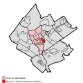
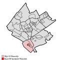
 Map - NL - Westland - Wijk 03 Maasdijk - Buurt 06 Maasambacht.svg 375 × 375; 46 KB
-

-
-

-
 Map - NL - Westland - Wijk 03 Maasdijk - Buurt 51 Honderdland.svg 375 × 375; 46 KB
-
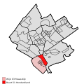
 Map - NL - Westland - Wijk 03 Maasdijk - Buurt 52 Oranjepolder.svg 375 × 375; 46 KB
-
 Map - NL - Westland - Wijk 03 Maasdijk.svg 625 × 575; 11 KB
-

-
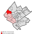
 Map - NL - Westland - Wijk 04 's-Gravenzande - Buurt 10 Heenweg.svg 375 × 375; 46 KB
-
-

-

-

-
-
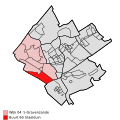
 Map - NL - Westland - Wijk 04 's-Gravenzande - Buurt 70 Olieblok.svg 375 × 375; 46 KB
-

-
 Map - NL - Westland - Wijk 04 's-Gravenzande.svg 625 × 575; 11 KB
-
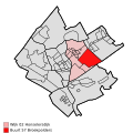
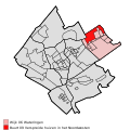
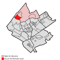 Map - NL - Westland - Wijk 05 Monster - Buurt 00 Monster-Zuid.svg 375 × 375; 46 KB
-
-
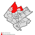
 Map - NL - Westland - Wijk 05 Monster - Buurt 02 Monster-Noord.svg 375 × 375; 46 KB
-
 Map - NL - Westland - Wijk 05 Monster - Buurt 03 Poeldijk.svg 375 × 375; 46 KB
-
-
 Map - NL - Westland - Wijk 05 Monster.svg 625 × 575; 11 KB
-
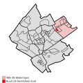
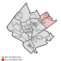 Map - NL - Westland - Wijk 06 Wateringen - Buurt 00 Wateringen.svg 375 × 375; 46 KB
-

-
 Map - NL - Westland - Wijk 06 Wateringen - Buurt 02 Plan-Zuid.svg 375 × 375; 46 KB
-

-

-
-

-

-
-
 Map - NL - Westland - Wijk 06 Wateringen - Buurt 10 Vliettuinen.svg 375 × 375; 46 KB
-
 Map - NL - Westland - Wijk 06 Wateringen - Buurt 11 Essellanden.svg 375 × 375; 46 KB
-
 Map - NL - Westland - Wijk 06 Wateringen.svg 625 × 575; 11 KB
-
 Map - NL - Westland - Wijk 07 De Lier - Buurt 00 De Lier.svg 375 × 375; 46 KB
-
 Map - NL - Westland - Wijk 07 De Lier - Buurt 01 Nieuwe-Tuinen.svg 375 × 375; 46 KB
-

-
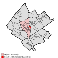
 Map - NL - Westland - Wijk 07 De Lier - Buurt 03 Oostbuurt.svg 375 × 375; 46 KB
-
 Map - NL - Westland - Wijk 07 De Lier - Buurt 04 Noord.svg 375 × 375; 46 KB
-
 Map - NL - Westland - Wijk 07 De Lier - Buurt 05 Hoefpolder.svg 375 × 375; 46 KB
-

-
 Map - NL - Westland - Wijk 07 De Lier.svg 625 × 575; 11 KB
-
 Map NL - Westland - 's-Gravenzande.png 800 × 600; 16 KB
-
 Map NL - Westland - De Lier.png 800 × 600; 16 KB
-
 Map NL - Westland - Heenweg.png 800 × 600; 16 KB
-
 Map NL - Westland - Honselersdijk.png 800 × 600; 16 KB
-
 Map NL - Westland - Kwintsheul.png 800 × 600; 16 KB
-
 Map NL - Westland - Maasdijk.png 800 × 600; 16 KB
-
 Map NL - Westland - Mariëndijk.png 800 × 600; 16 KB
-
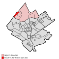
 Map NL - Westland - Monster.png 800 × 600; 16 KB
-
 Map NL - Westland - Naaldwijk.png 800 × 600; 16 KB
-
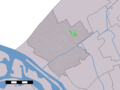
 Map NL - Westland - Nieuwe Tuinen.png 800 × 600; 16 KB
-
 Map NL - Westland - Oostbuurt.png 800 × 600; 16 KB
-
 Map NL - Westland - Poeldijk.png 800 × 600; 16 KB
-
 Map NL - Westland - Rolpaal.png 800 × 600; 16 KB
-
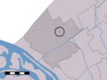
 Map NL - Westland - Ter Heijde.png 800 × 600; 16 KB
-
 Map NL - Westland - Wateringen.png 800 × 600; 16 KB
-
 Map NL - Westland - Westerlee.png 800 × 600; 16 KB


.svg)


