Category:Locator maps of municipalities of Greece (1997-2010)
Jump to navigation
Jump to search
Media in category "Locator maps of municipalities of Greece (1997-2010)"
The following 51 files are in this category, out of 51 total.
-
 2010 Dimi Pirea numbered.svg 543 × 1,663; 140 KB
-
 Achaia municipalities numbered.svg 803 × 551; 85 KB
-
 Aitoloakarnania municipalities numbered.svg 617 × 528; 263 KB
-
 Arcadia municipalities numbered.svg 763 × 695; 114 KB
-
 Argolida municipalities numbered.svg 683 × 474; 93 KB
-
 Arta municipalities numbered.svg 621 × 632; 85 KB
-
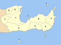
 Chania municipalities numbered.png 600 × 844; 61 KB
-
 Chios municipalities numbered.png 800 × 565; 49 KB
-
 Corfu muncipalities numbered.png 600 × 781; 52 KB
-
 Cyclades municipalities numbered.png 875 × 1,000; 117 KB
-
 Drama municipalities numbered.png 800 × 563; 54 KB
-
 Dytiki attiki municipalities numbered.svg 677 × 451; 78 KB
-
 Euboea municipalities numbered.png 1,000 × 704; 127 KB
-
 Evros municipalities numbered.png 700 × 995; 75 KB
-
-
 Florina prefecture, Greece - political map - municipality level - numbered.svg 1,025 × 617; 117 KB
-
 Fokida municipalities numbered.svg 541 × 484; 73 KB
-
 Fthiotida municipalities numbered.svg 633 × 430; 140 KB
-
 Grevena municipalities numbered.svg 732 × 432; 66 KB
-
 Hleia municipalities numbered.svg 700 × 750; 78 KB
-
 Hmathia municipalities numbered.svg 654 × 486; 64 KB
-
 Ioannina municipalities numbered.svg 524 × 746; 115 KB
-
 Iraklio municipalities numbered.png 1,000 × 803; 120 KB
-
 Karditsa municipalities numbered.svg 657 × 492; 92 KB
-
 Kastoria municipalities numbered.svg 566 × 590; 70 KB
-
 Kavala municipalities numbered.png 800 × 608; 58 KB
-
 Kefallinia muncipalities numbered.png 600 × 480; 41 KB
-
 Kilkis municipalities numbered.svg 708 × 491; 70 KB
-
 Korinthia municipalities numbered.svg 620 × 360; 72 KB
-
 Kozani municipalities numbered.svg 675 × 585; 97 KB
-
 Lakonia municipalities numbered.svg 723 × 836; 123 KB
-
 Lasithi municipalities numbered.png 1,000 × 733; 72 KB
-
 Lefkada municipalities numbered.png 800 × 583; 68 KB
-
 Lesbos municipalities numbered.png 800 × 652; 56 KB
-
 Location of municipalities within the Dodecanese Islands.png 1,000 × 762; 85 KB
-
 Magnesia municipalities numbered.svg 799 × 503; 118 KB
-
 Messinia municipalities numbered.svg 749 × 866; 112 KB
-
 Pella municipalities numbered.svg 649 × 488; 69 KB
-
 Pieria municipalities numbered.svg 555 × 727; 78 KB
-
 Pireas nomarchia municipalities numbered.png 400 × 1,238; 57 KB
-
 Preveza municipalities numbered.svg 607 × 491; 80 KB
-
 Rethymnon municipalities numbered.png 800 × 677; 61 KB
-
 Rodopi municipalities numbered.png 800 × 557; 65 KB
-
 Samos municipalities numbered.png 800 × 409; 37 KB
-
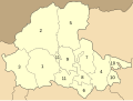
 Serres.png 1,600 × 1,152; 375 KB
-
 Thesprotia municipalities numbered.svg 580 × 616; 64 KB
-
 Thessaloniki Prefecture, Greece - political map - low detail - numbered.svg 1,052 × 744; 368 KB
-
 Trikala municipalities numbered.svg 579 × 382; 103 KB
-
 Voiotia municipalities numbered.svg 711 × 424; 113 KB
-
 Xanthi municipalities numbered.png 800 × 749; 71 KB
-
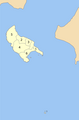 Zakynthos municipalities numbered.png 600 × 912; 30 KB


