Category:Locator maps of districts of Wiesbaden
Jump to navigation
Jump to search
Media in category "Locator maps of districts of Wiesbaden"
The following 54 files are in this category, out of 54 total.
-
 Auringen in Wiesbaden.svg 1,126 × 1,014; 1.45 MB
-
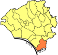
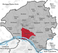 Biebrich in Wiesbaden.svg 1,126 × 1,014; 1.45 MB
-
 Bierstadt in Wiesbaden.svg 1,126 × 1,014; 1.45 MB
-
 Breckenheim in Wiesbaden.svg 1,126 × 1,014; 1.45 MB
-
 Delkenheim in Wiesbaden.svg 1,126 × 1,014; 1.45 MB
-
 Dotzheim in Wiesbaden.svg 1,126 × 1,014; 1.45 MB
-
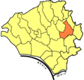
 Erbenheim in Wiesbaden.svg 1,126 × 1,014; 1.45 MB
-
 Frauenstein in Wiesbaden.svg 1,126 × 1,014; 1.45 MB
-
 Hessloch in Wiesbaden.svg 1,126 × 1,014; 1.45 MB
-
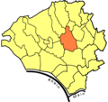
 Igstadt in Wiesbaden.svg 1,126 × 1,014; 1.45 MB
-
 Klarenthal in Wiesbaden.svg 1,126 × 1,014; 1.45 MB
-
 Kloppenheim in Wiesbaden.svg 1,126 × 1,014; 1.45 MB
-
 Mainz-Amöneburg in Wiesbaden.svg 1,126 × 1,014; 1.45 MB
-
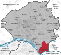
 Mainz-Kastel in Wiesbaden.svg 1,126 × 1,014; 1.45 MB
-
 Mainz-Kostheim in Wiesbaden.svg 1,126 × 1,014; 1.45 MB
-
 Medenbach in Wiesbaden.svg 1,126 × 1,014; 1.45 MB
-
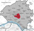
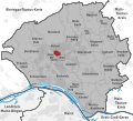
 Mitte in Wiesbaden.svg 1,126 × 1,014; 1.45 MB
-
 Naurod in Wiesbaden.svg 1,126 × 1,014; 1.45 MB
-
 Nordenstadt in Wiesbaden.svg 1,126 × 1,014; 1.45 MB
-
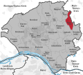
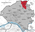
 Nordost in Wiesbaden.svg 1,126 × 1,014; 1.45 MB
-
 Rambach in Wiesbaden.svg 1,126 × 1,014; 1.45 MB
-
 Rheingauviertel, Hollerborn in Wiesbaden.svg 1,126 × 1,014; 1.45 MB
-
 Schierstein in Wiesbaden.svg 1,126 × 1,014; 1.45 MB
-
 Sonnenberg in Wiesbaden.svg 1,126 × 1,014; 1.45 MB
-
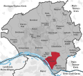
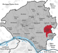
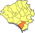
 Südost in Wiesbaden.svg 1,126 × 1,014; 1.45 MB
-
 Westend, Bleichstraße in Wiesbaden.svg 1,126 × 1,014; 1.45 MB
-
 Wiesbaden districts.png 1,001 × 947; 165 KB
-
 Wiesbaden Karte Amöneburg.PNG 1,001 × 945; 56 KB
-
 Wiesbaden Karte Auringen.PNG 1,001 × 945; 56 KB
-
 Wiesbaden Karte Biebrich.PNG 1,001 × 945; 56 KB
-
 Wiesbaden Karte Bierstadt.PNG 1,001 × 945; 56 KB
-
 Wiesbaden Karte Breckenheim.PNG 1,001 × 945; 56 KB
-
 Wiesbaden Karte Delkenheim.PNG 1,001 × 945; 56 KB
-
 Wiesbaden Karte Dotzheim.PNG 1,001 × 945; 56 KB
-
 Wiesbaden Karte Erbenheim.PNG 1,001 × 945; 56 KB
-
 Wiesbaden Karte Frauenstein.PNG 1,001 × 945; 56 KB
-
 Wiesbaden Karte Heßloch.PNG 1,001 × 945; 56 KB
-
 Wiesbaden Karte Igstadt.PNG 1,001 × 945; 56 KB
-
 Wiesbaden Karte Kastel.PNG 1,001 × 945; 56 KB
-
 Wiesbaden Karte Klarenthal.PNG 1,001 × 945; 56 KB
-
 Wiesbaden Karte Kloppenheim.PNG 1,001 × 945; 56 KB
-
 Wiesbaden Karte Kostheim.PNG 1,001 × 945; 56 KB
-
 Wiesbaden Karte Medenbach.PNG 1,001 × 945; 56 KB
-
 Wiesbaden Karte Mitte.PNG 1,001 × 945; 56 KB
-
 Wiesbaden Karte Naurod.PNG 1,001 × 945; 56 KB
-
 Wiesbaden Karte Nordenstadt.PNG 1,001 × 945; 56 KB
-
 Wiesbaden Karte Nordost.PNG 1,001 × 945; 56 KB
-
 Wiesbaden Karte Rambach.PNG 1,001 × 945; 56 KB
-
 Wiesbaden Karte Rheingauviertel.PNG 1,001 × 945; 56 KB
-
 Wiesbaden Karte Schierstein.PNG 1,001 × 945; 56 KB
-
 Wiesbaden Karte Sonnenberg.PNG 1,001 × 945; 56 KB
-
 Wiesbaden Karte Südost.PNG 1,001 × 945; 56 KB
-
 Wiesbaden Karte Westend.PNG 1,001 × 945; 56 KB
-
 Wiesbaden subdivisions.svg 1,126 × 1,014; 1.45 MB


