Category:Locator maps of communities in Denbighshire
Jump to navigation
Jump to search
Media in category "Locator maps of communities in Denbighshire"
The following 39 files are in this category, out of 39 total.
-
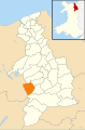
 Wales Denbighshire Community Aberwheeler map.svg 512 × 773; 560 KB
-
 Wales Denbighshire Community Betws Gwerfil Goch map.svg 512 × 773; 560 KB
-
 Wales Denbighshire Community Bodelwyddan map.svg 512 × 773; 560 KB
-
 Wales Denbighshire Community Bodfari map.svg 512 × 773; 560 KB
-
 Wales Denbighshire Community Bryneglwys map.svg 512 × 773; 560 KB
-
 Wales Denbighshire Community Cefnmeiriadog map.svg 512 × 773; 560 KB
-
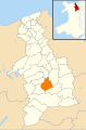
 Wales Denbighshire Community Clocaenog map.svg 512 × 773; 560 KB
-
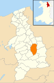
 Wales Denbighshire Community Corwen map.svg 512 × 773; 560 KB
-
 Wales Denbighshire Community Cwm map.svg 512 × 773; 560 KB
-
 Wales Denbighshire Community Cyffylliog map.svg 512 × 773; 560 KB
-
 Wales Denbighshire Community Cynwyd map.svg 512 × 773; 560 KB
-
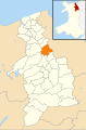
 Wales Denbighshire Community Denbigh map.svg 512 × 773; 560 KB
-
 Wales Denbighshire Community Derwen map.svg 512 × 773; 560 KB
-
 Wales Denbighshire Community Dyserth map.svg 512 × 773; 560 KB
-
 Wales Denbighshire Community Efenechtyd map.svg 512 × 773; 560 KB
-
 Wales Denbighshire Community Gwyddelwern map.svg 512 × 773; 560 KB
-
 Wales Denbighshire Community Henllan map.svg 512 × 773; 560 KB
-
 Wales Denbighshire Community Llanarmon-yn-Ial map.svg 512 × 773; 560 KB
-
 Wales Denbighshire Community Llanbedr Dyffryn Clwyd map.svg 512 × 773; 560 KB
-
 Wales Denbighshire Community Llandegla map.svg 512 × 773; 560 KB
-
 Wales Denbighshire Community Llandrillo map.svg 512 × 773; 560 KB
-
 Wales Denbighshire Community Llandyrnog map.svg 512 × 773; 560 KB
-
 Wales Denbighshire Community Llanelidan map.svg 512 × 773; 560 KB
-
 Wales Denbighshire Community Llanfair Dyffryn Clwyd map.svg 512 × 773; 560 KB
-
 Wales Denbighshire Community Llanferres map.svg 512 × 773; 560 KB
-
 Wales Denbighshire Community Llangollen map.svg 512 × 773; 560 KB
-
 Wales Denbighshire Community Llangynhafal map.svg 512 × 773; 560 KB
-
 Wales Denbighshire Community Llanrhaeadr-Yng-Nghinmeirch map.svg 512 × 773; 560 KB
-
 Wales Denbighshire Community Llantysilio map.svg 512 × 773; 560 KB
-
 Wales Denbighshire Community Llanynys map.svg 512 × 773; 560 KB
-
 Wales Denbighshire Community Nantglyn map.svg 512 × 773; 560 KB
-
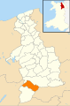
 Wales Denbighshire Community Prestatyn map.svg 512 × 773; 560 KB
-
 Wales Denbighshire Community Rhuddlan map.svg 512 × 773; 560 KB
-
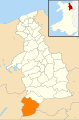
 Wales Denbighshire Community Rhyl map.svg 512 × 773; 560 KB
-
 Wales Denbighshire Community Ruthin map.svg 512 × 773; 560 KB
-
 Wales Denbighshire Community St Asaph map.svg 512 × 773; 560 KB
-
 Wales Denbighshire Community Trefnant map.svg 512 × 773; 560 KB
-
 Wales Denbighshire Community Tremeirchion map.svg 512 × 773; 560 KB
-
 Wales Denbighshire Community Waen map.svg 512 × 773; 560 KB


