Category:Locator maps of boroughs in Wuppertal
Jump to navigation
Jump to search
Media in category "Locator maps of boroughs in Wuppertal"
The following 20 files are in this category, out of 20 total.
-
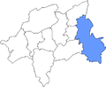
 Stadtbezirk 0 Lage in Wuppertal.png 423 × 347; 8 KB
-
 Stadtbezirk 1 Lage in Wuppertal.png 423 × 347; 8 KB
-
 Stadtbezirk 2 Lage in Wuppertal.png 423 × 347; 8 KB
-
 Stadtbezirk 3 Lage in Wuppertal.png 423 × 347; 8 KB
-
 Stadtbezirk 4 Lage in Wuppertal.png 423 × 347; 8 KB
-
 Stadtbezirk 5 Lage in Wuppertal.png 423 × 347; 8 KB
-
 Stadtbezirk 6 Lage in Wuppertal.png 423 × 347; 8 KB
-
 Stadtbezirk 7 Lage in Wuppertal.png 423 × 347; 7 KB
-
 Stadtbezirk 8 Lage in Wuppertal.png 423 × 347; 8 KB
-
 Stadtbezirk 9 Lage in Wuppertal.png 423 × 347; 8 KB
-
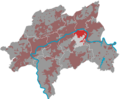
 W-BarmenPos.png 800 × 658; 96 KB
-
 W-CronenbergPos.png 800 × 658; 95 KB
-
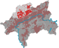
 W-Elberfeld-WestPos.png 800 × 658; 95 KB
-
 W-ElberfeldPos.png 800 × 658; 95 KB
-
 W-HeckinghausenPos.png 800 × 658; 95 KB
-
 W-Langerfeld-BeyenburgPos.png 800 × 658; 96 KB
-
 W-OberbarmenPos.png 800 × 658; 95 KB
-
 W-RonsdorfPos.png 2,408 × 1,980; 305 KB
-
 W-Uellendahl KaternbergPos.png 800 × 658; 95 KB
-
 W-VohwinkelPos.png 800 × 658; 96 KB


