Category:Locator maps of Las Marías, Puerto Rico
Jump to navigation
Jump to search
Media in category "Locator maps of Las Marías, Puerto Rico"
The following 18 files are in this category, out of 18 total.
-
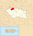 Alto Sano, Las Marías, Puerto Rico locator map.png 1,100 × 1,196; 169 KB
-
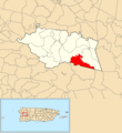
 Anones, Las Marías, Puerto Rico locator map.png 1,100 × 1,196; 170 KB
-
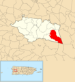
 Bucarabones, Las Marías, Puerto Rico locator map.png 1,100 × 1,196; 169 KB
-
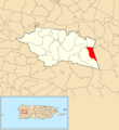
 Buena Vista, Las Marías, Puerto Rico locator map.png 1,100 × 1,196; 169 KB
-
 Cerrote, Las Marías, Puerto Rico locator map.png 1,100 × 1,196; 169 KB
-
 Chamorro, Las Marías, Puerto Rico locator map.png 1,100 × 1,196; 169 KB
-
 Espino, Las Marías, Puerto Rico locator map.png 1,100 × 1,196; 169 KB
-
 Furnias, Las Marías, Puerto Rico locator map.png 1,100 × 1,196; 169 KB
-
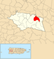
 Las Marías barrio-pueblo, Las Marías, Puerto Rico locator map.png 1,100 × 1,196; 169 KB
-
 Las Marías, Puerto Rico locator map.png 1,100 × 1,196; 176 KB
-
 Locator-map-Puerto-Rico-Las-Marías.svg 1,332 × 360; 97 KB
-
 Maravilla Este, Las Marías, Puerto Rico locator map.png 1,100 × 1,196; 169 KB
-
 Maravilla Norte, Las Marías, Puerto Rico locator map.png 1,100 × 1,196; 169 KB
-
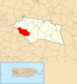
 Maravilla Sur, Las Marías, Puerto Rico locator map.png 1,100 × 1,196; 170 KB
-
 Naranjales, Las Marías, Puerto Rico locator map.png 1,100 × 1,196; 170 KB
-
 Palma Escrita, Las Marías, Puerto Rico locator map.png 1,100 × 1,196; 170 KB
-
 Purísima Concepción, Las Marías, Puerto Rico locator map.png 1,100 × 1,196; 169 KB
-
 Río Cañas, Las Marías, Puerto Rico locator map.png 1,100 × 1,196; 169 KB


