Category:Locator maps of Kreis Herford
Jump to navigation
Jump to search
Subcategories
This category has only the following subcategory.
Media in category "Locator maps of Kreis Herford"
The following 27 files are in this category, out of 27 total.
-
 BWahlkreis 134.svg 550 × 520; 82 KB
-
 Herford Regierungsbezirk Detmold NRW.png 662 × 630; 76 KB
-
 Karte-Ravensberger-Hügelland.PNG 400 × 500; 53 KB
-
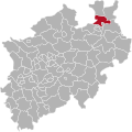 Kreis Herford in NRW 31 12 1968.svg 584 × 583; 84 KB
-
 Lage des Kreises Herford in Deutschland (1969).png 176 × 235; 2 KB
-
 Lage des Kreises Herford in Deutschland.PNG 197 × 235; 3 KB
-
 Lage Ravensberger Land.png 300 × 375; 38 KB
-
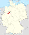
 Locator map HF in Germany.svg 1,075 × 1,273; 637 KB
-
 Locator map HF in North Rhine-Westphalia.svg 657 × 656; 479 KB
-
 Locator map Minden-Ravensberg in Germany.svg 1,075 × 1,273; 947 KB
-
 North rhine w hf old.png 263 × 245; 39 KB
-
 North rhine w hf.png 593 × 585; 73 KB
-
 North rhine w HF.svg 660 × 660; 221 KB
-
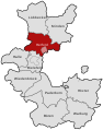
 NRW RB Detmold HF.svg 592 × 584; 246 KB
-
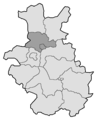
 RB Detmold 1947-1968 Kreiseinteilung Herford 2.png 250 × 310; 35 KB
-
 RB Detmold 1947-1968 Kreiseinteilung Herford.png 311 × 386; 6 KB
-
 RB Detmold 1949-1968 beschriftet Herford Stadt- und Landkreis.svg 570 × 724; 103 KB
-
 RB Detmold 1949-1968 beschriftet Herford.svg 570 × 724; 101 KB
-
 RB Detmold 1975 beschriftet Herford.svg 575 × 724; 39 KB
-
 RB Detmold 1975 Kreiseinteilung Herford.png 309 × 388; 3 KB
-
 RB Minden 1817-1831 beschriftet Buende Herford.svg 570 × 724; 93 KB
-
 RB Minden 1817-1831 beschriftet Herford.svg 570 × 724; 93 KB
-
 RB Minden 1832-1878 Kreiseinteilung Herford.png 310 × 386; 6 KB
-
 RB Minden 1878-1911 Kreiseinteilung Herford.png 310 × 386; 6 KB
-

-
 RB Minden 1911-1947 (Bielefeld ab 1930) beschriftet Herford.svg 570 × 724; 87 KB
-
 RB Minden 1911-1947 Kreiseinteilung Herford.png 310 × 386; 6 KB


.png)


_beschriftet_Herford_Stadt-_und_Landkreis.svg)
_beschriftet_Herford.svg)
