Category:Locator maps of Erwitte
Jump to navigation
Jump to search
Media in category "Locator maps of Erwitte"
The following 15 files are in this category, out of 15 total.
-
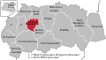
 Karte Erwitte Ortsteil Bad Westernkotten.svg 600 × 340; 75 KB
-
 Karte Erwitte Ortsteil Berenbrock.svg 600 × 340; 75 KB
-
 Karte Erwitte Ortsteil Böckum.svg 600 × 340; 75 KB
-
 Karte Erwitte Ortsteil Ebbinghausen.svg 600 × 340; 75 KB
-
 Karte Erwitte Ortsteil Eikeloh.svg 600 × 340; 75 KB
-
 Karte Erwitte Ortsteil Horn-Millinghausen.svg 600 × 340; 75 KB
-
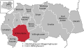
 Karte Erwitte Ortsteil Merklinghausen-Wiggeringhausen.svg 600 × 340; 75 KB
-
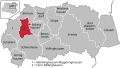
 Karte Erwitte Ortsteil Norddorf.svg 600 × 340; 75 KB
-
 Karte Erwitte Ortsteil Schallern.svg 600 × 340; 75 KB
-
 Karte Erwitte Ortsteil Schmerlecke.svg 600 × 340; 75 KB
-
 Karte Erwitte Ortsteil Seringhausen.svg 600 × 340; 75 KB
-
 Karte Erwitte Ortsteil Stirpe.svg 600 × 340; 72 KB
-
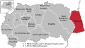
 Karte Erwitte Ortsteil Völlinghausen.svg 600 × 340; 72 KB
-
 Karte Erwitte Ortsteil Weckinghausen.svg 600 × 340; 75 KB
-
 Karte Erwitte Ortsteile.svg 600 × 340; 75 KB


