Category:Locator maps of Bannewitz
Jump to navigation
Jump to search
Media in category "Locator maps of Bannewitz"
The following 16 files are in this category, out of 16 total.
-
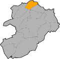
 Locator map Bannewitz in Bannewitz.svg 931 × 907; 54 KB
-
 Locator map Boderitz in Bannewitz.svg 931 × 907; 54 KB
-
 Locator map Börnchen in Bannewitz.svg 931 × 907; 54 KB
-
 Locator map Cunnersdorf in Bannewitz.svg 931 × 907; 54 KB
-
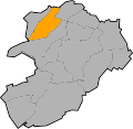
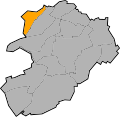
 Locator map Eutschütz in Bannewitz.svg 931 × 907; 54 KB
-
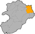
 Locator map Gaustritz in Bannewitz.svg 931 × 907; 54 KB
-
 Locator map Golberode in Bannewitz.svg 931 × 907; 54 KB
-
 Locator map Goppeln in Bannewitz.svg 931 × 907; 54 KB
-
 Locator map Hänichen in Bannewitz.svg 931 × 907; 54 KB
-
 Locator map Nöthnitz in Bannewitz.svg 931 × 907; 54 KB
-
 Locator map Possendorf in Bannewitz.svg 931 × 907; 54 KB
-
 Locator map Rippien in Bannewitz.svg 931 × 907; 54 KB
-
 Locator map Rosentitz in Bannewitz.svg 931 × 907; 54 KB
-
 Locator map Welschhufe in Bannewitz.svg 931 × 907; 54 KB
-
 Locator map Wilmsdorf in Bannewitz.svg 931 × 907; 54 KB
-
 Municipal subdivisions of Bannewitz.svg 931 × 907; 63 KB


