Category:Location maps of regions of Denmark
Jump to navigation
Jump to search
Media in category "Location maps of regions of Denmark"
The following 20 files are in this category, out of 20 total.
-
 Denmark Capital Region location map (ca).svg 1,000 × 657; 244 KB
-
 Denmark Capital Region location map Bornholm frame.svg 1,053 × 744; 2.88 MB
-
 Denmark Capital Region location map.svg 1,000 × 657; 243 KB
-
 Denmark Capital Region rel location map.svg 1,000 × 657; 330 KB
-
 Denmark Central Jutland Farvskov.png 984 × 718; 381 KB
-
 Denmark Central Jutland location map (ca).svg 512 × 375; 91 KB
-
 Denmark Central Jutland location map.svg 1,001 × 733; 256 KB
-
 Denmark Central Jutland rel location map.svg 1,001 × 733; 394 KB
-
 Denmark North Jutland location map (ca).svg 1,000 × 729; 158 KB
-
 Denmark North Jutland location map.svg 1,000 × 729; 158 KB
-
 Denmark North Jutland rel location map.svg 1,000 × 729; 253 KB
-
 Denmark Region of Southern Denmark.png 1,000 × 766; 203 KB
-
 Denmark South Denmark location map (da).svg 1,000 × 766; 252 KB
-
 Denmark South Denmark location map.svg 1,000 × 766; 252 KB
-
 Denmark South Denmark rel location map.svg 1,000 × 766; 402 KB
-
 Denmark Zealand location map (da).svg 602 × 1,000; 249 KB
-
 Denmark Zealand location map.svg 602 × 1,000; 249 KB
-
 Denmark Zealand rel location map.svg 602 × 1,000; 289 KB
-
 Faroe Islands location map.svg 775 × 1,000; 63 KB
-
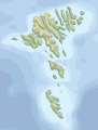 Faroe Islands topographic location map.svg 1,683 × 2,208; 538 KB
.svg)


.svg)


.svg)


.svg)


.svg)


