Category:Local elections maps of Portugal
Jump to navigation
Jump to search
Media in category "Local elections maps of Portugal"
The following 47 files are in this category, out of 47 total.
-
 2021 Portuguese local election results by municipality map.png 983 × 1,454; 80 KB
-
 Autárquicas portuguesas de 1976 (Mapa).png 1,162 × 1,477; 88 KB
-
 Autárquicas portuguesas de 1979 (Mapa Câmara).png 1,162 × 1,477; 88 KB
-
 Autárquicas portuguesas de 1982 (Mapa Câmara).png 1,162 × 1,477; 88 KB
-
 Autárquicas portuguesas de 1985 (Mapa Câmara Municipal).png 1,162 × 1,477; 88 KB
-
 Autárquicas portuguesas de 1989 (Mapa Câmara).png 1,162 × 1,477; 88 KB
-
 Autárquicas portuguesas de 1993 (Mapa Câmara).png 1,162 × 1,477; 88 KB
-
 Autárquicas portuguesas de 1997 (Mapa Câmara).png 1,162 × 1,477; 88 KB
-
 Autárquicas portuguesas de 2001 (Mapa Câmara Municipal).png 1,162 × 1,477; 89 KB
-
 Autárquicas portuguesas de 2005 (Mapa Câmara Municipal).png 1,162 × 1,477; 89 KB
-
 Autárquicas portuguesas de 2013 (Mapa).png 1,162 × 1,477; 89 KB
-
 Barcelos Autárquicas 2013.png 770 × 367; 52 KB
-
 Braga Autárquicas 2013.png 770 × 335; 37 KB
-
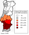 CDU electoral results local 2005.png 278 × 334; 9 KB
-
 CDU electoral results local 2005.svg 180 × 366; 185 KB
-
 Eleições autárquicas de 2017 em Almada (Mapa).png 769 × 360; 23 KB
-
 Eleições autárquicas de 2017 em Barcelos (Mapa).png 770 × 367; 44 KB
-
 Eleições autárquicas de 2017 em Braga (Mapa).png 776 × 335; 32 KB
-
 Eleições autárquicas de 2017 em Cascais (Mapa).png 797 × 301; 19 KB
-
 Eleições autárquicas de 2017 em Coimbra (Mapa).png 772 × 335; 38 KB
-
 Eleições autárquicas de 2017 em Gondomar (Mapa).png 769 × 360; 23 KB
-
 Eleições autárquicas de 2017 em Leiria (Mapa).png 772 × 351; 32 KB
-
 Eleições autárquicas de 2017 em Lisboa.png 797 × 335; 32 KB
-
 Eleições autárquicas de 2017 em Loures (Mapa).png 795 × 335; 31 KB
-
 Eleições autárquicas de 2017 em Matosinhos (Mapa).png 770 × 335; 30 KB
-
 Eleições autárquicas de 2017 em Odivelas (Mapa).png 771 × 335; 27 KB
-
 Eleições autárquicas de 2017 em Oeiras (Mapa).png 782 × 301; 23 KB
-
 Eleições autárquicas de 2017 em Santa Maria da Feira (Mapa).png 771 × 335; 37 KB
-
 Eleições autárquicas de 2017 em Setúbal (Mapa).png 769 × 276; 23 KB
-
 Eleições autárquicas de 2017 em Sintra (Mapa).png 771 × 335; 26 KB
-
 Eleições autárquicas de 2017 em Vila Franca de Xira (Mapa).png 776 × 335; 27 KB
-
 Eleições autárquicas de 2017 em Vila Nova de Famalicão (Mapa).png 789 × 335; 31 KB
-
 Eleições autárquicas de 2017 em Vila Nova de Gaia.png 769 × 335; 26 KB
-
 Eleições autárquicas de 2017 na Amadora (Mapa).png 769 × 348; 22 KB
-
 Eleições autárquicas de 2017 na Maia (Mapa).png 769 × 335; 24 KB
-
 Eleições autárquicas de 2017 no concelho de Coimbra (Mapa).png 772 × 335; 38 KB
-
 Eleições autárquicas de 2017 no Funchal (Mapa).png 799 × 335; 28 KB
-
 Eleições autárquicas de 2017 no Porto.png 769 × 286; 19 KB
-
 Eleições autárquicas portuguesas de 2017 no Seixal (Mapa).png 784 × 335; 23 KB
-
 Eleições autárquicas portuguesas de 2017.png 1,162 × 1,477; 89 KB
-
 Guimarães Autárquicas 2013.png 769 × 335; 42 KB
-
 Guimarães Legislativas 2015.png 260 × 335; 17 KB
-
 Lisboa Autárquicas 2013.png 819 × 335; 31 KB
-
 Partido mais votado por Concelho (Câmara Municipal).png 1,162 × 1,477; 89 KB
-
 Portuguese municipalities parties-polls 2009-09-10.PNG 1,162 × 1,477; 106 KB
-
 Portuguese municipalities parties.PNG 1,162 × 1,477; 112 KB
-
 Vila Nova de Famalicão Autárquicas 2013.png 768 × 335; 33 KB

.png)
.png)
.png)
.png)
.png)
.png)
.png)
.png)
.png)
.png)


.png)
.png)
.png)
.png)
.png)
.png)

.png)
.png)
.png)
.png)
.png)
.png)
.png)

.png)
.png)
.png)
.png)
.png)


.png)


.png)
.png)
.png)