Category:Llansantffraid Glyn Ceiriog
Jump to navigation
Jump to search
community in Wrexham county borough, Wales, UK   | |||||
| Upload media | |||||
| Pronunciation audio | |||||
|---|---|---|---|---|---|
| Instance of | |||||
| Named after | |||||
| Location | Wrexham County Borough, Wales | ||||
| Population |
| ||||
| Area |
| ||||
 | |||||
English: Llansantffraid Glyn Ceiriog, sometimes Llansanffraid Glyn Ceiriog or often simply Glyn Ceiriog, is a local government community in the Ceiriog Valley, in Wrexham County Borough in Wales. It is in the Clwyd South Senedd constituency and Clwyd South parliamentary constituency.

Subcategories
This category has the following 2 subcategories, out of 2 total.
G
P
Media in category "Llansantffraid Glyn Ceiriog"
The following 21 files are in this category, out of 21 total.
-

-
 Buildings over the years - geograph.org.uk - 1254145.jpg 640 × 428; 65 KB
-
 Emerging spring cereal - geograph.org.uk - 1254175.jpg 640 × 428; 67 KB
-
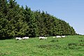 Ewes and lambs by the windbreak - geograph.org.uk - 1670192.jpg 640 × 429; 98 KB
-
 Extensive sheep grazings - geograph.org.uk - 1670213.jpg 640 × 428; 72 KB
-
-
 Forestry track with hardwood saplings - geograph.org.uk - 1670270.jpg 640 × 419; 104 KB
-
 In the shade of a mature tree - geograph.org.uk - 1670170.jpg 640 × 420; 70 KB
-
 Interpretation boards on the Battle of Crogen (1165).jpg 640 × 480; 106 KB
-
 Just like the beach - geograph.org.uk - 1254199.jpg 640 × 428; 100 KB
-
 Llansantffraid Glyn Ceiriog, UK - panoramio.jpg 3,264 × 2,448; 2.5 MB
-
 Looking towards the clear fell - geograph.org.uk - 1670252.jpg 640 × 429; 88 KB
-
 Moorland on the eastern slopes of Y Foel - geograph.org.uk - 362783.jpg 640 × 358; 119 KB
-
 Red Plaque - Battle of Crogen geograph-3604117-by-BrianPritchard.jpg 3,456 × 2,592; 2.1 MB
-
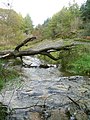 Stream by Ceiriog Forest - geograph.org.uk - 269101.jpg 480 × 640; 87 KB
-
 Timber left by the roadside - geograph.org.uk - 1671373.jpg 640 × 386; 85 KB
-
 Track back into the trees of Nantyr - geograph.org.uk - 1671341.jpg 640 × 462; 103 KB
-

-
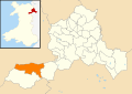 Wales Wrexham Community Llansantffraid Glyn Ceiriog map.svg 512 × 362; 495 KB
-
 Y Foel trigpoint - geograph.org.uk - 362822.jpg 640 × 397; 124 KB
-
 South-west slopes of Y Foel - geograph.org.uk - 192019.jpg 640 × 481; 141 KB


.jpg)


