Category:Llanrhaeadr-ym-Mochnant
Jump to navigation
Jump to search
Alemannisch: Llanrhaeadr-ym-Mochnant isch e Dorf in Mittelwales. S lit zwischem Fluss Rhaeadr bi de Berwyn-Berg.
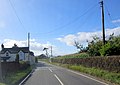
Cymraeg: Mae Llanrhaeadr-ym-Mochnant yn bentref a phlwyf yng ngogledd Powys. Fe'i lleolir ym mhen mwyaf gogleddol y sir tua 9 milltir i'r gorllewin o Groesoswallt a 12 milltir i'r de o Langollen. Rhed y lôn B4580 trwy'r pentref.
Norsk bokmål: Llanrhaeadr-ym-Mochnant er en landsby i Powys, Wales. Den ligger ved elven Rhaeadr, ved Berwynfjellene.
village and community in Powys, Wales  | |||||
| Upload media | |||||
| Instance of | |||||
|---|---|---|---|---|---|
| Location | Powys, Wales | ||||
| Population |
| ||||
| Area |
| ||||
| official website | |||||
 | |||||
Subcategories
This category has the following 6 subcategories, out of 6 total.
L
- Llanarmon Mynydd Mawr (5 F)
P
- Pistyll Rhaeadr (78 F)
Media in category "Llanrhaeadr-ym-Mochnant"
The following 200 files are in this category, out of 778 total.
(previous page) (next page)-
 'Trigfan' cottage on Park Street, Llanrhaeadr-ym-Mochnant - geograph.org.uk - 6186685.jpg 3,264 × 2,448; 1.74 MB
-
 10 Park Street, Llanrhaeadr-ym-Mochnant - geograph.org.uk - 6186682.jpg 1,958 × 2,611; 1.81 MB
-
 7 Park Street, Llanrhaeadr-ym-Mochnant - geograph.org.uk - 6185424.jpg 1,836 × 2,448; 1.9 MB
-
 8 Park Street, Llanrhaeadr-ym-Mochnant - geograph.org.uk - 6186678.jpg 1,836 × 2,448; 2.02 MB
-
 9 Park Street, Llanrhaeadr-ym-Mochnant - geograph.org.uk - 6186680.jpg 1,836 × 2,448; 1.81 MB
-
 A gate on the hairpin - geograph.org.uk - 1164803.jpg 640 × 480; 121 KB
-
 A light mist in the valley - geograph.org.uk - 2531995.jpg 640 × 480; 101 KB
-
 A lone tree - geograph.org.uk - 5696219.jpg 1,102 × 1,469; 584 KB
-
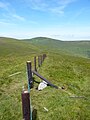 A new fence on Foel Wen - geograph.org.uk - 6241043.jpg 1,958 × 2,611; 1.72 MB
-
 A rather vague track - geograph.org.uk - 5710697.jpg 1,469 × 1,102; 675 KB
-
 A re-purposed railway wagon - geograph.org.uk - 6239249.jpg 1,469 × 1,102; 839 KB
-
 A short hillside track below Tan-y-ffridd - geograph.org.uk - 6179995.jpg 1,469 × 1,102; 840 KB
-
 A small Dam at the head of Afon Iwrch - geograph.org.uk - 2784747.jpg 720 × 540; 106 KB
-
 A stream valley at Rhyd-y-gau - geograph.org.uk - 881555.jpg 640 × 480; 61 KB
-
 A tarn beside the lane - geograph.org.uk - 3682497.jpg 4,000 × 3,000; 2.46 MB
-

-
-
 Above Afon Rhaeadr - geograph.org.uk - 3672376.jpg 2,560 × 1,920; 2.16 MB
-
 Above Afon Rhaeadr - geograph.org.uk - 3680206.jpg 1,707 × 1,902; 462 KB
-
 Above Gwern-feifod farm. - geograph.org.uk - 881840.jpg 640 × 480; 59 KB
-
 Above the Sheepfold - geograph.org.uk - 3680493.jpg 2,560 × 1,920; 1.98 MB
-
 Above the waterfall - geograph.org.uk - 2352576.jpg 1,200 × 800; 179 KB
-
 Access track to Sychnant farm - geograph.org.uk - 6180649.jpg 1,469 × 1,102; 735 KB
-
 Across Llyn Lluncaws to Cadair Berwyn - geograph.org.uk - 5710484.jpg 1,469 × 1,102; 714 KB
-
 Afon Disgynfa - geograph.org.uk - 5770472.jpg 5,184 × 3,888; 5.84 MB
-
 Afon Iwrch - geograph.org.uk - 6169129.jpg 5,184 × 3,888; 5.47 MB
-
 Afon Iwrch - geograph.org.uk - 698350.jpg 640 × 398; 84 KB
-
 Afon Iwrch at Pont Maesmochnant - geograph.org.uk - 477097.jpg 640 × 480; 244 KB
-
 Afon Rhaeadr in Llanrhaeadr-ym-Mochnant - geograph.org.uk - 4987774.jpg 1,064 × 1,600; 737 KB
-
 Afon Tanat downstream - geograph.org.uk - 2120170.jpg 640 × 480; 105 KB
-
 Afon Tanat upstream - geograph.org.uk - 2120172.jpg 640 × 480; 86 KB
-
 Agricultural building in Afon Iwrch's upper valley - geograph.org.uk - 3682473.jpg 4,000 × 3,000; 2.46 MB
-
 Along the Berwyn ridge from Moel Sych - geograph.org.uk - 6425556.jpg 5,640 × 3,760; 1.97 MB
-
 Along the bridleway looking southwest - geograph.org.uk - 6166280.jpg 1,469 × 1,102; 748 KB
-
 Along the crest of Craig y Llyn - geograph.org.uk - 5710502.jpg 1,316 × 988; 405 KB
-
 Along The Lane - geograph.org.uk - 710106.jpg 427 × 640; 91 KB
-
 Along the lane by Glanrafon - geograph.org.uk - 6179705.jpg 1,102 × 1,469; 1.01 MB
-
 Along the lane in the valley near Tyn-y-ffridd - geograph.org.uk - 6179723.jpg 1,469 × 1,102; 643 KB
-
 Along the lane towards Cefn-y-rhodfa - geograph.org.uk - 6179977.jpg 1,469 × 1,102; 724 KB
-
 Along the ridge on the east side of Mynydd Tarw - geograph.org.uk - 6239304.jpg 1,469 × 1,102; 592 KB
-
 Alun Evans, Llanrhaeadr-ym-Mochnant NLW3364099.jpg 426 × 596; 66 KB
-
 An old man, Llanrhaeadr-ym-Mochnant NLW3362648.jpg 443 × 590; 47 KB
-
 Approaching Cadair Berwyn - geograph.org.uk - 5769018.jpg 3,888 × 5,184; 5.37 MB
-
 Approaching Cadair Berwyn New Top - geograph.org.uk - 4986452.jpg 3,008 × 2,000; 1.33 MB
-
 Approaching Tai-newyddion - geograph.org.uk - 6180651.jpg 1,469 × 1,102; 525 KB
-
 As high as you can get around here - geograph.org.uk - 2532036.jpg 640 × 480; 103 KB
-
 At the end of the footpath - geograph.org.uk - 5710473.jpg 1,469 × 1,102; 633 KB
-
 Autumn colours near Pistyll Rhaeadr - geograph.org.uk - 4215981.jpg 640 × 360; 69 KB
-
 B4391 and B4396 road junction - geograph.org.uk - 2120176.jpg 640 × 480; 79 KB
-
 B4391 junction with B4580 - geograph.org.uk - 4620664.jpg 640 × 372; 115 KB
-
 B4396 at Pentrefelin - geograph.org.uk - 3673469.jpg 2,970 × 2,092; 778 KB
-
 B4396 heads west - geograph.org.uk - 4475329.jpg 640 × 428; 108 KB
-
 B4580 crosses Pont Maesmochnant - geograph.org.uk - 3673479.jpg 3,234 × 2,375; 1.27 MB
-
 B4580 in Llanrhaeadr-ym-Mochnant - geograph.org.uk - 4987781.jpg 1,600 × 1,064; 602 KB
-
 B4580 lane junction southeast of Llanrhaeadr-ym-Mochnant - geograph.org.uk - 3673486.jpg 3,372 × 2,375; 1.27 MB
-
 B4580 passes the former National School - geograph.org.uk - 3673501.jpg 3,895 × 2,522; 1.79 MB
-
 B4580 passes the Wynnstay Arms - geograph.org.uk - 3673505.jpg 3,254 × 2,480; 1.28 MB
-

-
 Barn at Bryn Coch - geograph.org.uk - 6223033.jpg 5,184 × 3,888; 4.18 MB
-
 Barn at Maes - geograph.org.uk - 6169128.jpg 5,184 × 3,888; 4.35 MB
-
 Barns at Maes - geograph.org.uk - 6239245.jpg 1,469 × 1,102; 584 KB
-
 Bay Horse (6014766934).jpg 1,600 × 1,200; 333 KB
-
 Below Pistyll Rhaeadr - geograph.org.uk - 6639007.jpg 694 × 1,024; 403 KB
-
 Below Pistyll Rhaeadr, 1971 - geograph.org.uk - 4908783.jpg 1,515 × 2,134; 6.36 MB
-
 Bench Mark, Llanrhaeadr ym Mochnant - geograph.org.uk - 980297.jpg 413 × 640; 84 KB
-
 Bethesda chapel (CM), Llanrhaeadr-ym-Mochnant NLW3363435.jpg 435 × 602; 67 KB
-
 Between Foel-ddu and Rhos - geograph.org.uk - 6239282.jpg 1,469 × 1,102; 600 KB
-
 Boggy hollow on Cadair Berwyn - geograph.org.uk - 5710638.jpg 1,469 × 1,102; 648 KB
-
 Boggy path on the Berwyn ridge - geograph.org.uk - 5613925.jpg 6,000 × 4,000; 5.74 MB
-
 Boundary Stone II on Mynydd Tarw - geograph.org.uk - 6239308.jpg 1,836 × 2,448; 2.32 MB
-
 Bridge over Afon Rhaeadr - geograph.org.uk - 1741269.jpg 1,024 × 724; 253 KB
-
 Bridge over Cwm Ffynnon - geograph.org.uk - 978707.jpg 640 × 480; 156 KB
-
 Bridlepath gate on the Berwyn - geograph.org.uk - 2853045.jpg 1,600 × 1,200; 393 KB
-
 Bridlepath sign near Tyn-y-fedwen - geograph.org.uk - 2852979.jpg 3,216 × 4,288; 3.09 MB
-
 Bridleway and track in the valley - geograph.org.uk - 6179700.jpg 1,469 × 1,102; 777 KB
-
 British Legion carnival in Llanrhaeadr-ym-Mochnant (4459528967).jpg 609 × 456; 61 KB
-
 British Legion carnival in Llanrhaeadr-ym-Mochnant (7131388339).jpg 2,281 × 3,102; 2.09 MB
-

-
 Bronze Age cairn on Cadair Berwyn - geograph.org.uk - 5710543.jpg 1,632 × 1,224; 718 KB
-
 Bryn-gwyn farm, with Rhos hill beyond - geograph.org.uk - 881537.jpg 640 × 480; 65 KB
-
 Bwlch Maen Gwynedd from the Berwyns - geograph.org.uk - 6607942.jpg 640 × 480; 71 KB
-
 Bwthyn-hedd cottage - geograph.org.uk - 6187558.jpg 2,448 × 3,264; 2.11 MB
-
 Cabin in Afon Iwrch's upper valley - geograph.org.uk - 3678948.jpg 3,511 × 2,499; 1.53 MB
-
 Cadair Berwyn - geograph.org.uk - 2320788.jpg 640 × 344; 42 KB
-
 Cadair Berwyn - geograph.org.uk - 2751338.jpg 720 × 540; 61 KB
-
 Cadair Berwyn - geograph.org.uk - 4933542.jpg 640 × 480; 62 KB
-
 Cadair Berwyn Cairn I - geograph.org.uk - 5710623.jpg 1,795 × 1,346; 785 KB
-
 Cadair Berwyn from summit at 830 metres - geograph.org.uk - 6678353.jpg 5,184 × 2,912; 4.33 MB
-
 Cadair Berwyn from the east - geograph.org.uk - 5710705.jpg 1,469 × 1,102; 636 KB
-
 Cadair Berwyn N ridge burial cairn - geograph.org.uk - 6241452.jpg 2,774 × 2,081; 2.05 MB
-
 Cadair Berwyn N ridge burial cairn - geograph.org.uk - 6241459.jpg 2,448 × 1,836; 2.58 MB
-
 Cadair Berwyn's old summit - geograph.org.uk - 5710615.jpg 1,795 × 1,346; 804 KB
-
 Cadair Berwyn's true summit - Craig Uchaf - geograph.org.uk - 5710528.jpg 1,469 × 1,102; 575 KB
-
 Cairn and wind-shelter - geograph.org.uk - 6563845.jpg 5,184 × 3,888; 4.2 MB
-

-
 Cairn on the Berwyn ridge - geograph.org.uk - 1875250.jpg 640 × 480; 91 KB
-
 Camping at Pistyll Rhaeadr, c.1950 - geograph.org.uk - 3646178.jpg 640 × 427; 65 KB
-
 Capel Seion in Llanrhaeadr-ym-Mochnant - geograph.org.uk - 6187386.jpg 2,774 × 2,081; 1.69 MB
-
 Car park, Pistyll Rhaeadr - geograph.org.uk - 6471511.jpg 1,024 × 703; 249 KB
-

-
 Cattle, Llanrhaeadr ym Mochnant - geograph.org.uk - 980068.jpg 640 × 426; 75 KB
-
 Cefn Coch, minor road - geograph.org.uk - 5494986.jpg 1,024 × 768; 251 KB
-
 Cefn Coch, valley - geograph.org.uk - 5494991.jpg 1,024 × 768; 194 KB
-
 Cefn-coch, minor road - geograph.org.uk - 5495926.jpg 1,024 × 768; 201 KB
-
 Cefn-coch, sheep grazing - geograph.org.uk - 5495898.jpg 1,024 × 768; 235 KB
-
 Cefn-coch, signpost - geograph.org.uk - 5495909.jpg 1,024 × 769; 253 KB
-

-
 Cerrig Geneugiaid - geograph.org.uk - 6169125.jpg 5,184 × 3,888; 3.43 MB
-
 Cerrig Geneugiaid - geograph.org.uk - 6239853.jpg 1,469 × 1,102; 532 KB
-
 Cerrig Poethion - geograph.org.uk - 2784724.jpg 720 × 463; 36 KB
-
 Cerrig Poethion - geograph.org.uk - 3680613.jpg 2,560 × 1,920; 1.32 MB
-
 Cerrig Poethion - geograph.org.uk - 4933529.jpg 640 × 480; 57 KB
-
 Chapel at Penygarnedd - geograph.org.uk - 241771.jpg 640 × 480; 125 KB
-
 Chewing the cud - geograph.org.uk - 978504.jpg 640 × 480; 138 KB
-
 Church (35677131125).jpg 3,872 × 3,268; 10.38 MB
-
 Church Frontage - geograph.org.uk - 692527.jpg 640 × 425; 82 KB
-
 Church of St Dogfan, Llanrhaeadr-ym-Mochnant - geograph.org.uk - 6164901.jpg 3,264 × 2,448; 2.46 MB
-
 Cliffs on Craig-y-Mwn - geograph.org.uk - 6556782.jpg 5,184 × 3,888; 4.6 MB
-
 Col on the Berwyn ridge - geograph.org.uk - 4986572.jpg 1,600 × 1,064; 296 KB
-

-
 Country retreat - geograph.org.uk - 978506.jpg 640 × 443; 130 KB
-
 Course of the River Rhaeadr - geograph.org.uk - 978499.jpg 640 × 480; 106 KB
-
 Craggy hill above Gardden Fawr - geograph.org.uk - 881477.jpg 640 × 480; 82 KB
-
 Crags above Nant-y-Llyn - geograph.org.uk - 2352785.jpg 1,200 × 800; 106 KB
-
 Craig Berwyn - geograph.org.uk - 1994498.jpg 1,712 × 2,288; 773 KB
-
 Craig Uchaf - Cadair Berwyn New Top - geograph.org.uk - 5769442.jpg 5,184 × 3,888; 4.78 MB
-

-
 Craig y Llyn - geograph.org.uk - 3681046.jpg 2,560 × 1,920; 1.98 MB
-
 Craig y Llyn - geograph.org.uk - 4933535.jpg 640 × 480; 88 KB
-
 Craig y Llyn - the steep east wall of Moel Sych - geograph.org.uk - 5710497.jpg 1,469 × 1,102; 585 KB
-
 Craig y Mwn - geograph.org.uk - 2782409.jpg 4,320 × 3,240; 3.16 MB
-
 Craig y Mwn - geograph.org.uk - 979707.jpg 640 × 426; 63 KB
-
 Craig y Mwn - geograph.org.uk - 979948.jpg 640 × 426; 84 KB
-
 Craig y Mwyn Lead Mine - geograph.org.uk - 3044555.jpg 1,712 × 2,288; 811 KB
-
 Craig-Y- Mwn - geograph.org.uk - 3210385.jpg 960 × 540; 132 KB
-
 Craig-Y-Mwn Lead Mine - geograph.org.uk - 883293.jpg 640 × 480; 93 KB
-
 Cwm Ffynnon - geograph.org.uk - 3227331.jpg 960 × 540; 78 KB
-
 Cwm Gloywfa - geograph.org.uk - 2782448.jpg 4,320 × 3,240; 3.11 MB
-
 Cwm Maen Gwynedd - geograph.org.uk - 2751165.jpg 720 × 540; 50 KB
-
 Cwm Maen Gwynedd above Plas-criafol - geograph.org.uk - 6179714.jpg 1,469 × 1,102; 646 KB
-
 Cwm Maen Gwynedd from summit at 830 metres - geograph.org.uk - 6678354.jpg 5,184 × 2,912; 3.81 MB
-
 Cwm Maen Gwynedd from the road - geograph.org.uk - 6179710.jpg 1,469 × 1,102; 644 KB
-
 Cwm Maen Gwynedd.jpg 4,032 × 3,024; 5.13 MB
-
 Cwm Rhiwiau in the distance - geograph.org.uk - 2782441.jpg 4,320 × 3,240; 3.11 MB
-
 Cwm-Rhiwiau and Moel Sych - geograph.org.uk - 5946254.jpg 3,489 × 2,385; 523 KB
-
 Daft Dog comes trotting back - geograph.org.uk - 5696116.jpg 1,469 × 1,102; 667 KB
-
 Daft Dog makes for Cadair Berwyn - geograph.org.uk - 5710507.jpg 1,102 × 1,469; 634 KB
-
 Descending Cadair Berwyn - geograph.org.uk - 3681069.jpg 1,920 × 2,560; 2.15 MB
-
 Descending Godor - geograph.org.uk - 3682582.jpg 2,560 × 1,920; 2 MB
-
 Descending Trum Felen - geograph.org.uk - 4986433.jpg 1,600 × 1,064; 453 KB
-
 Distance Plate (34836375734).jpg 2,959 × 3,412; 7.77 MB
-
 Down the hill to Llanrhaeadr ym Mochnant - geograph.org.uk - 980070.jpg 640 × 426; 119 KB
-
 Down the lane towards Llanrhaeadr-ym-Mochnant - geograph.org.uk - 6164971.jpg 979 × 1,306; 533 KB
-
 Down the old byway near Votty - geograph.org.uk - 6239255.jpg 979 × 1,306; 603 KB
-
 Dr Jones, Llanrhaeadr-ym-Mochnant NLW3364100.jpg 429 × 595; 35 KB
-
 Dyffryn Tanat - geograph.org.uk - 978921.jpg 640 × 480; 78 KB
-
 Dyffryn Tanat - geograph.org.uk - 979946.jpg 640 × 426; 84 KB
-
 Eastern slopes of Pen-y-ffridd - geograph.org.uk - 1178915.jpg 640 × 480; 241 KB
-

-
 Elim Chapel, Cefn-coch - geograph.org.uk - 4987145.jpg 1,600 × 1,064; 314 KB
-
 End of the metalled road - geograph.org.uk - 4987147.jpg 1,600 × 1,064; 391 KB
-
 Entrance to Maes-y-bwch - geograph.org.uk - 3673781.jpg 4,000 × 3,000; 2.87 MB
-
 Escarpment between Moel Sych and Cadair Berwyn - geograph.org.uk - 5946341.jpg 3,480 × 2,395; 709 KB
-
 Face Bark - geograph.org.uk - 699010.jpg 389 × 640; 133 KB
-
 Faint path below Moel yr Ewig - geograph.org.uk - 5695607.jpg 1,469 × 1,102; 900 KB
-
 Farm near Pistyll Rhaeadr - geograph.org.uk - 978761.jpg 640 × 480; 84 KB
-
 Farm road to Garn Uchaf - geograph.org.uk - 979956.jpg 640 × 480; 107 KB
-
 Farm track above Cwm Maen Gwynedd - geograph.org.uk - 2680155.jpg 640 × 480; 73 KB
-
 Farm track at Rhyd-y-gau - geograph.org.uk - 2680151.jpg 640 × 480; 96 KB
-
 Farm track leaves Waterfall Street west of Tyn-y-Celyn - geograph.org.uk - 3673822.jpg 4,000 × 3,000; 2.37 MB
-
 Farm track on Mynydd Mawr - geograph.org.uk - 2680166.jpg 640 × 480; 103 KB
-
 Farm track to Foel-llyn - geograph.org.uk - 2680147.jpg 640 × 480; 107 KB
-
 Farmland above Tanat Valley - geograph.org.uk - 3682605.jpg 2,560 × 1,920; 1.97 MB
-
 Farmland north of Llanfyllin - geograph.org.uk - 2577965.jpg 1,024 × 680; 181 KB
-
 Fence adjacent to Foel Wen South Top - geograph.org.uk - 6169122.jpg 5,184 × 3,888; 5.23 MB
-
 Fence corner on Tomle summit (2434') - geograph.org.uk - 6169121.jpg 5,184 × 3,888; 4.28 MB
-
 Fence corner on Tomle's summit - geograph.org.uk - 5710686.jpg 1,432 × 1,074; 561 KB
-

-
 Fence junction at the summit of Moel Poethion - geograph.org.uk - 5696226.jpg 1,469 × 1,102; 598 KB
-
 Fence line extending westwards from Mynydd Tarw - geograph.org.uk - 2723827.jpg 1,500 × 1,125; 1.61 MB
-
 Fence on the ridge above Cwm Ffynnon - geograph.org.uk - 5696223.jpg 1,469 × 1,102; 607 KB
-
 Fence, stile and boardwalk - geograph.org.uk - 5769445.jpg 5,184 × 3,888; 4.91 MB
-
 Fenced field with Mynydd Tarw - geograph.org.uk - 2724728.jpg 1,500 × 1,125; 1.58 MB
-
 Fenced Water - geograph.org.uk - 711600.jpg 640 × 427; 131 KB
-
 Fenceline below Tomle - geograph.org.uk - 5710674.jpg 1,402 × 1,052; 535 KB
-
 Fenceline making for Foel Wen - geograph.org.uk - 6239857.jpg 1,469 × 1,102; 600 KB
-
 Fenceline on Moel yr Ewig - geograph.org.uk - 5696114.jpg 1,469 × 1,102; 636 KB
-
 Fenceline on Mynydd Tarw - geograph.org.uk - 6239855.jpg 1,469 × 1,102; 639 KB
-

-
 Fenceline on the south ridge of Moel yr Ewig - geograph.org.uk - 5696221.jpg 1,469 × 1,102; 644 KB
-
 Fences below the New Top of Cadair Berwyn - geograph.org.uk - 5710514.jpg 1,469 × 1,102; 620 KB
-
 Fences on the North Top of Godor - geograph.org.uk - 5696119.jpg 1,553 × 1,165; 738 KB
-
 Ffarm Bryngwyn Farm - geograph.org.uk - 4933559.jpg 640 × 544; 160 KB
-
 Field boundary on the hillside - geograph.org.uk - 1212182.jpg 640 × 480; 87 KB
-
 Field of Silage - geograph.org.uk - 980369.jpg 640 × 426; 50 KB
-
 Fields above Afon Rhaeadr - geograph.org.uk - 4987476.jpg 1,600 × 1,064; 185 KB
-
 First glimpse of Llyn Lluncaws - geograph.org.uk - 5710479.jpg 1,469 × 1,102; 771 KB
-
 Flat summit of Godor 2228' - 679m - geograph.org.uk - 6591371.jpg 5,184 × 3,888; 4.6 MB
-
 Foel-llyn farm - geograph.org.uk - 881501.jpg 640 × 480; 68 KB
-
 Foel-llyn farmhouse - geograph.org.uk - 881434.jpg 640 × 480; 106 KB


.jpg)


,_Llanrhaeadr-ym-Mochnant_NLW3363435.jpg)


.jpg)
.jpg)


.jpg)


.jpg)


_-_geograph.org.uk_-_6169121.jpg)


