Category:Llangyniew (community)
Jump to navigation
Jump to search
community in Powys, Wales | |||||
| Upload media | |||||
| Instance of | |||||
|---|---|---|---|---|---|
| Location | Powys, Wales | ||||
| Population |
| ||||
 | |||||
Subcategories
This category has the following 2 subcategories, out of 2 total.
L
- Llangynyw (121 F)
P
Media in category "Llangyniew (community)"
The following 175 files are in this category, out of 175 total.
-
 A458 at Llangynyw junction - geograph.org.uk - 4825647.jpg 640 × 494; 44 KB
-
 A458 junction near Cyfronydd - geograph.org.uk - 2131432.jpg 640 × 480; 49 KB
-

-
 Across the fields to Garth-fach - geograph.org.uk - 2348973.jpg 640 × 480; 90 KB
-

-
 Afon Banwy from Banwy bridge on railway - geograph.org.uk - 3113479.jpg 640 × 480; 115 KB
-
 Approaching cross roads at Rhos Pen Bwa - geograph.org.uk - 2874158.jpg 640 × 491; 123 KB
-
 Autumn colours along the road - geograph.org.uk - 2133157.jpg 640 × 480; 98 KB
-
 B4389 from outside The Cottage - geograph.org.uk - 2126195.jpg 640 × 442; 66 KB
-
 Banwy Bridge, Welshpool ^ Llanfair Light Railway - geograph.org.uk - 2511364.jpg 2,112 × 2,816; 2.22 MB
-
 Banwy View on lane from Henllan - geograph.org.uk - 2131430.jpg 640 × 480; 77 KB
-
 Barn at Henllan Ucha - geograph.org.uk - 3156118.jpg 640 × 480; 80 KB
-
 Barn on the hill - geograph.org.uk - 2437322.jpg 640 × 427; 54 KB
-
 Bench against the tree trunk - geograph.org.uk - 2187848.jpg 640 × 480; 95 KB
-
 Bench overlooking the Vyrnwy valley - geograph.org.uk - 2187857.jpg 640 × 480; 99 KB
-
 Bend in road above Tynrhos - geograph.org.uk - 1574156.jpg 640 × 437; 100 KB
-
 Bridleway near Llangyniew - geograph.org.uk - 3156306.jpg 640 × 480; 79 KB
-
 Bridleway or green lane - geograph.org.uk - 3156284.jpg 640 × 480; 116 KB
-
 Bridleway to Llangyniew - geograph.org.uk - 3156240.jpg 640 × 480; 101 KB
-
 Bryn-y-fedwen near Pontrobert - geograph.org.uk - 2187753.jpg 640 × 480; 70 KB
-
 Bryn-y-fedwen near Pontrobert - geograph.org.uk - 2741050.jpg 640 × 480; 72 KB
-
 Bryn-y-fedwyn near Pontrobert - geograph.org.uk - 3861463.jpg 640 × 480; 100 KB
-
 Chalets at Henllan-fawr - geograph.org.uk - 3156166.jpg 640 × 480; 97 KB
-
 Chalets at Henllan-fawr - geograph.org.uk - 3156224.jpg 640 × 480; 84 KB
-
 Chalets At Henllan. - geograph.org.uk - 2432503.jpg 640 × 428; 98 KB
-
 Collecting the mail - geograph.org.uk - 2133189.jpg 640 × 480; 105 KB
-
 Converted chapel at Pontrobert - geograph.org.uk - 2133162.jpg 640 × 480; 72 KB
-
 Croeso i Bowys- Welcome to Powys - geograph.org.uk - 4601977.jpg 640 × 464; 62 KB
-
 Crossroads at Rhos Pen Bwa - geograph.org.uk - 2133192.jpg 640 × 480; 81 KB
-
 Crossroads on road to Pontrobert - geograph.org.uk - 2133150.jpg 640 × 480; 92 KB
-
 Cyfronydd Hall - geograph.org.uk - 3156256.jpg 640 × 480; 53 KB
-
-

-

-
 East from Dolobran Hall turning - geograph.org.uk - 3071443.jpg 640 × 501; 73 KB
-

-
 East towards the A495 junction - geograph.org.uk - 3071448.jpg 640 × 394; 58 KB
-

-
 Empty snow fields above the Vyrnwy - geograph.org.uk - 2187837.jpg 640 × 480; 62 KB
-

-

-
 Entrance to Ffridd Mathrafal - geograph.org.uk - 2131416.jpg 640 × 477; 87 KB
-
 Entrance to Garth Fach - geograph.org.uk - 2133171.jpg 640 × 480; 65 KB
-

-
 Farm at Wig - geograph.org.uk - 1574171.jpg 640 × 480; 93 KB
-
 Farm laager - geograph.org.uk - 3861457.jpg 640 × 480; 92 KB
-
 Farm near Pontrobert - geograph.org.uk - 3861499.jpg 640 × 480; 63 KB
-
 Farm off B4382 south of Wig - geograph.org.uk - 1574168.jpg 640 × 480; 102 KB
-

-
 Field above Pontrobert - geograph.org.uk - 2741151.jpg 640 × 480; 79 KB
-
 Field edge footpath - geograph.org.uk - 3155960.jpg 640 × 480; 65 KB
-
 Flowers on the verge in Pontrobert - geograph.org.uk - 3861469.jpg 640 × 480; 153 KB
-
 Footpath beside a stream - geograph.org.uk - 2348940.jpg 640 × 480; 171 KB
-

-
 Forestry clearance - geograph.org.uk - 2133176.jpg 640 × 480; 86 KB
-
 Frozen pond - geograph.org.uk - 2187821.jpg 640 × 480; 88 KB
-
 Gate on the Glyndwr Way near Pontrobert - geograph.org.uk - 2187789.jpg 640 × 480; 100 KB
-
 Glyndwr's Way at Pontrobert - geograph.org.uk - 4671487.jpg 4,608 × 3,456; 5.29 MB
-
 Glyndwr's Way near Pontrobert - geograph.org.uk - 4671494.jpg 4,608 × 3,456; 5.09 MB
-
 Glyndwrs Way at Pontrobert - geograph.org.uk - 2133165.jpg 640 × 480; 95 KB
-
 Grassy field on the north bank of Afon Banwy - geograph.org.uk - 5030958.jpg 1,024 × 615; 152 KB
-
 Half way across the ford below Ty Mawr - geograph.org.uk - 3001041.jpg 2,560 × 1,920; 1.18 MB
-

-
 Heniarth - 2013 - geograph.org.uk - 4100667.jpg 3,648 × 2,736; 1.35 MB
-
 Heniarth - 2013 - geograph.org.uk - 4101017.jpg 3,648 × 2,736; 1.87 MB
-
 Heniarth Crossing - geograph.org.uk - 5881139.jpg 1,280 × 851; 573 KB
-
 Heniarth halt - geograph.org.uk - 2437431.jpg 640 × 427; 84 KB
-
 Heniarth Halt - geograph.org.uk - 5881092.jpg 1,280 × 851; 556 KB
-
 Heniarth Halt - geograph.org.uk - 5881096.jpg 1,280 × 851; 513 KB
-
 Heniarth Halt - geograph.org.uk - 5881130.jpg 1,280 × 851; 518 KB
-
 Heniarth Halt crossing - geograph.org.uk - 2437418.jpg 640 × 427; 88 KB
-
 Heniarth Halt from railway bridge - geograph.org.uk - 5542428.jpg 640 × 429; 94 KB
-
 Heniarth halt station sign - geograph.org.uk - 2437421.jpg 640 × 427; 99 KB
-
 Heniarth Mill from railway - geograph.org.uk - 5542430.jpg 640 × 427; 89 KB
-
 Henllan-fach - geograph.org.uk - 3156142.jpg 640 × 480; 73 KB
-
 Henllan-fawr - geograph.org.uk - 3156203.jpg 640 × 480; 90 KB
-
 House at Tan-y-ffridd - geograph.org.uk - 3031778.jpg 4,000 × 2,657; 1.66 MB
-
 Junction of A495 and B4392 - geograph.org.uk - 1574143.jpg 640 × 480; 104 KB
-
 Lane approaching Henllan - geograph.org.uk - 2131426.jpg 640 × 480; 101 KB
-
 Lane approaching Henllan Ucha - geograph.org.uk - 2131420.jpg 640 × 480; 126 KB
-
 Lane approaching Ty-mawr farm - geograph.org.uk - 3156097.jpg 640 × 480; 74 KB
-

-
 Lane near Groes-ddu - geograph.org.uk - 1574157.jpg 640 × 480; 108 KB
-
 Lane near Henllan Ucha farm - geograph.org.uk - 3156111.jpg 640 × 480; 100 KB
-
 Lane north west from Rhos Pen Bwa - geograph.org.uk - 2133181.jpg 640 × 480; 80 KB
-
 Lane to Llangyniew - geograph.org.uk - 2131418.jpg 640 × 480; 82 KB
-
 Lane to Parc Cynhinfa - geograph.org.uk - 1574162.jpg 640 × 480; 69 KB
-
 Long straight out of Pontrobert - geograph.org.uk - 3071437.jpg 640 × 476; 69 KB
-

-
 Looking towards Moel Bentyrch - geograph.org.uk - 3031691.jpg 3,648 × 2,736; 6.13 MB
-
 Maize field above Mathrafal Castle - geograph.org.uk - 3155983.jpg 640 × 480; 101 KB
-
 Mathrafal Farm - geograph.org.uk - 2753133.jpg 720 × 540; 70 KB
-
 Meifod road east of Penyrhos - geograph.org.uk - 2874155.jpg 640 × 529; 111 KB
-
 Motte mound at Mathrafal Castle - geograph.org.uk - 3156040.jpg 640 × 480; 125 KB
-
-

-
 Old chapel in Pontrobert - geograph.org.uk - 2187748.jpg 640 × 480; 69 KB
-
 Old corrugated barn beside the road - geograph.org.uk - 3155927.jpg 640 × 480; 88 KB
-

-
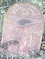
 Old Milepost by the B4389, Maes-y-Wennol - geograph.org.uk - 6102275.jpg 740 × 1,093; 206 KB
-
-

-
-
 Old Schoolhouse at Llangyniew - geograph.org.uk - 3156353.jpg 640 × 480; 67 KB
-
 On part of Glyndwr's Way - geograph.org.uk - 3861515.jpg 640 × 480; 101 KB
-
 On top of Mathrafal Castle motte mound - geograph.org.uk - 3156050.jpg 640 × 480; 112 KB
-
 Once there was woodland - geograph.org.uk - 2133169.jpg 640 × 480; 75 KB
-
 Ordnance Survey Cut Mark - geograph.org.uk - 5141760.jpg 640 × 588; 155 KB
-
 Ordnance Survey Cut Mark - geograph.org.uk - 5270666.jpg 640 × 353; 95 KB
-
 Part of Cefnllwyd farm - geograph.org.uk - 3155901.jpg 640 × 480; 78 KB
-

-

-
 Part of Mathrafal Castle motte mound - geograph.org.uk - 3156056.jpg 640 × 480; 114 KB
-
 Part of Mathrafal Castle remains - geograph.org.uk - 3156025.jpg 640 × 480; 92 KB
-
 Part of Mathrafal Castle site - geograph.org.uk - 3156071.jpg 640 × 480; 83 KB
-
-

-
 Part of the yard at Gwern-fawr farm - geograph.org.uk - 3864280.jpg 640 × 480; 95 KB
-
 Passing place on Pontrobert road - geograph.org.uk - 3071430.jpg 640 × 411; 108 KB
-
 Penhyros House - geograph.org.uk - 2874143.jpg 640 × 404; 96 KB
-
 Pontrobert from a hillside footpath - geograph.org.uk - 2187863.jpg 640 × 480; 65 KB
-
-
 Railway crossing Banwy bridge - geograph.org.uk - 2437443.jpg 640 × 427; 148 KB
-
 Railway curving towards the Banwy Bridge - geograph.org.uk - 2433646.jpg 640 × 480; 111 KB
-

-
 Rhos Cynhista farm above Pontrobert - geograph.org.uk - 2741205.jpg 640 × 480; 76 KB
-
 River Banwy from railway bridge - geograph.org.uk - 2437442.jpg 640 × 427; 102 KB
-
 River Vyrnwy as it passes the mill - geograph.org.uk - 2348949.jpg 640 × 480; 141 KB
-
 Road junction and phone box on B4382 - geograph.org.uk - 1574149.jpg 640 × 480; 59 KB
-
 Road junction at Glan-Vyrnwy - geograph.org.uk - 4825474.jpg 640 × 427; 46 KB
-
 Road junction at Newbridge - geograph.org.uk - 2438969.jpg 3,389 × 2,270; 2.62 MB
-
 Road junction for Pontrobert - geograph.org.uk - 1574145.jpg 640 × 480; 65 KB
-
 Road junction near Tynrhos - geograph.org.uk - 2133149.jpg 640 × 480; 65 KB
-
 Road junction of B4389 and A 495 - geograph.org.uk - 2126202.jpg 640 × 452; 65 KB
-
 Road sign at junction - geograph.org.uk - 1574151.jpg 480 × 640; 89 KB
-
 Sharp bend on road to Pontrobert - geograph.org.uk - 2133154.jpg 640 × 480; 89 KB
-
 Sheep near Heniarth halt - geograph.org.uk - 2437438.jpg 640 × 427; 74 KB
-
 Sheep pasture at Ty'n-y-wern - geograph.org.uk - 5030966.jpg 1,024 × 768; 131 KB
-
 Small retail premises in Pontrobert - geograph.org.uk - 3861490.jpg 640 × 480; 124 KB
-

-
 Spot Height 195m behind Llangyniew Church - geograph.org.uk - 2989491.jpg 1,296 × 968; 484 KB
-
 Static caravan park at Henllan-fawr - geograph.org.uk - 3156181.jpg 640 × 480; 87 KB
-
 Stone house at Wig - geograph.org.uk - 1574170.jpg 640 × 480; 76 KB
-

-
 Sweet Meadow Farm, Penyffridd - geograph.org.uk - 3032124.jpg 3,648 × 2,736; 6.71 MB
-
 Tanhouse Inn - geograph.org.uk - 1339063.jpg 640 × 426; 68 KB
-
 The Afon Banwy near Mathrafal Castle - geograph.org.uk - 3156077.jpg 640 × 480; 128 KB
-
 The bridge at Pontrobert - geograph.org.uk - 2348928.jpg 640 × 480; 121 KB
-
 The edge of Ffridd Mathrafal - geograph.org.uk - 2131414.jpg 640 × 480; 71 KB
-
 The graveyard at Hen Gapel - geograph.org.uk - 2187745.jpg 640 × 480; 88 KB
-
 The Hen Gapel at Pontrobert - geograph.org.uk - 2187736.jpg 640 × 480; 84 KB
-
 The Road To Llangyniew - geograph.org.uk - 319565.jpg 640 × 471; 115 KB
-
 The Royal Oak, Pontrobert - geograph.org.uk - 1903708.jpg 640 × 480; 100 KB
-
 Track curving towards Heniarth - geograph.org.uk - 2437439.jpg 640 × 427; 74 KB
-
 Track to a farmhouse - geograph.org.uk - 2348917.jpg 640 × 480; 108 KB
-
 Track to A458 from Heniarth halt - geograph.org.uk - 2437325.jpg 640 × 427; 100 KB
-
 Track to farm off B4382 - geograph.org.uk - 1574140.jpg 640 × 480; 148 KB
-
 Track to Heniarth Mill - geograph.org.uk - 5881103.jpg 1,280 × 851; 491 KB
-
 Trackway above Pontrobert - geograph.org.uk - 2741192.jpg 640 × 480; 132 KB
-
 Turn Right For Pontrobert - geograph.org.uk - 315485.jpg 640 × 480; 101 KB
-
 Ty-mawr farm house - geograph.org.uk - 3156100.jpg 640 × 480; 85 KB
-
 Up the hill towards Meifod - geograph.org.uk - 2126187.jpg 640 × 480; 83 KB
-

-

-

-
 View To Caravan Park - geograph.org.uk - 2432453.jpg 640 × 428; 113 KB
-
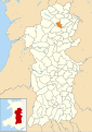 Wales Powys Community Llangyniew map.svg 512 × 723; 1.15 MB
-

-
 Welsh Postal van, Pontrobert - geograph.org.uk - 1903690.jpg 640 × 480; 96 KB
-
 Welshpool ^ Llanfair Light Railway - 1979 - geograph.org.uk - 2459320.jpg 2,272 × 1,515; 1.14 MB
-

-
 Y ddawns flodau - The floral dance - geograph.org.uk - 4605315.jpg 640 × 487; 62 KB
-
-
 Y Pafiliwn Pinc ym Meifod - geograph.org.uk - 4601972.jpg 640 × 383; 39 KB
-
 Confluence of the Banwy and Vyrnwy rivers - geograph.org.uk - 510415.jpg 640 × 481; 124 KB


