Category:Llanfachraeth
Jump to navigation
Jump to search
community and village in Anglesey, north-west Wales  | |||||
| Upload media | |||||
| Pronunciation audio | |||||
|---|---|---|---|---|---|
| Instance of | |||||
| Location | Isle of Anglesey, Wales | ||||
| Inception |
| ||||
| Population |
| ||||
 | |||||
- Note: this village, sometimes also referred to as "Llanfachreth" as that was the parish name, should not be confused with Llanfachreth, a village in Gwynedd.
Subcategories
This category has the following 2 subcategories, out of 2 total.
L
M
Media in category "Llanfachraeth"
The following 192 files are in this category, out of 192 total.
-
 A field of maize - geograph.org.uk - 1363456.jpg 640 × 480; 69 KB
-
 A listening lagomorph on the lane - geograph.org.uk - 1287051.jpg 640 × 449; 128 KB
-

-
 A view of Capel Pont yr Arw Baptist Chapel - geograph.org.uk - 5344717.jpg 3,888 × 5,184; 4.21 MB
-
 A welcome seat on the coastal path - geograph.org.uk - 5819047.jpg 1,024 × 768; 356 KB
-
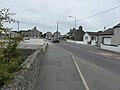
 A5025 through Llanfachraeth - geograph.org.uk - 2636414.jpg 640 × 480; 52 KB
-
 Abarim Methodist Chapel - geograph.org.uk - 6099478.jpg 1,280 × 960; 807 KB
-
 Access road to Ty Croes, Llanfachraeth - geograph.org.uk - 3787815.jpg 1,600 × 1,026; 260 KB
-
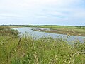
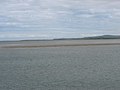
 Afon Alaw Estuary - geograph.org.uk - 4852275.jpg 640 × 422; 67 KB
-
 Afon Alaw near Llanfachraeth - geograph.org.uk - 4852295.jpg 640 × 472; 58 KB
-
 Afon Alaw near Llanfachraeth - geograph.org.uk - 4852465.jpg 640 × 480; 74 KB
-

-
 Anglesey Coast Path - geograph.org.uk - 4806915.jpg 640 × 473; 69 KB
-
 Anglesey Coast Path - geograph.org.uk - 4806920.jpg 640 × 479; 62 KB
-
 Anglesey Coast Path - geograph.org.uk - 4806926.jpg 640 × 475; 78 KB
-
 Anglesey Coast Path - geograph.org.uk - 4858751.jpg 640 × 473; 88 KB
-
 Anglesey Coastal Path - geograph.org.uk - 4656352.jpg 640 × 428; 74 KB
-
 Anglesey Coastal Path - geograph.org.uk - 4852308.jpg 640 × 480; 69 KB
-

-
-

-
 Approaching trig. pillar 44 - geograph.org.uk - 1295651.jpg 640 × 451; 57 KB
-
 Beach to the West of Llanfachraeth - geograph.org.uk - 194431.jpg 640 × 480; 109 KB
-

-

-
 Bend in the road south of Tyddyn Watcyn - geograph.org.uk - 1288955.jpg 640 × 480; 157 KB
-
 Bodardraeth - geograph.org.uk - 4858759.jpg 640 × 480; 68 KB
-

-
 Bodfardden-wen - geograph.org.uk - 6099593.jpg 1,280 × 960; 992 KB
-
 Bodlasan Fawr DSC 1307c.jpg 1,500 × 1,001; 136 KB
-
 Bodlasan House - geograph.org.uk - 1092692.jpg 640 × 480; 72 KB
-
 Bridge over the river Alaw - geograph.org.uk - 4852323.jpg 640 × 480; 67 KB
-
-
 Burnet Rose - geograph.org.uk - 4806939.jpg 640 × 480; 148 KB
-
 Capel Abarim, Llanfachraeth - geograph.org.uk - 4806751.jpg 640 × 480; 71 KB
-
 Capel Abarim, Llanfachraeth - geograph.org.uk - 6092352.jpg 1,024 × 683; 127 KB
-
 Capel Pont yr Arw Baptist Chapel - geograph.org.uk - 1364313.jpg 640 × 480; 55 KB
-

-
-
 Capel Ty'n y Maen - geograph.org.uk - 983473.jpg 640 × 480; 57 KB
-

-
 Cattle at Tyddyn Watcyn - geograph.org.uk - 992848.jpg 640 × 480; 154 KB
-
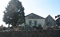
 Chapel at Llanfachraeth - geograph.org.uk - 4474221.jpg 640 × 480; 65 KB
-
 Chapel at Llanfachraeth - geograph.org.uk - 4474222.jpg 640 × 480; 64 KB
-
 Chapel, Llanfachraeth - geograph.org.uk - 3787855.jpg 1,600 × 1,005; 289 KB
-
 Climbing road west of Graianfryn - geograph.org.uk - 1295610.jpg 640 × 480; 52 KB
-

-

-
 Country road westwards towards the A 5025 - geograph.org.uk - 992698.jpg 640 × 436; 111 KB
-
 Creek north of Neuadd Wen bridge - geograph.org.uk - 1363458.jpg 640 × 480; 61 KB
-
 Curious calves - geograph.org.uk - 4806760.jpg 640 × 480; 97 KB
-

-
 Duneland path near Tywyn-gwyn - geograph.org.uk - 1365005.jpg 640 × 480; 84 KB
-
 Duneland vegetation near Tywyn-gwyn - geograph.org.uk - 1364999.jpg 640 × 481; 81 KB
-
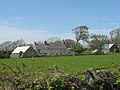
 Farm buildings at Dronwy - geograph.org.uk - 1289656.jpg 640 × 380; 33 KB
-
 Farm buildings, Aberalaw - geograph.org.uk - 4806764.jpg 640 × 480; 73 KB
-
 Farm road to Dronwy - geograph.org.uk - 1273111.jpg 640 × 313; 35 KB
-
 Farm track - geograph.org.uk - 6099590.jpg 1,280 × 960; 857 KB
-
 Farm track to Bottan Fawr - geograph.org.uk - 6099594.jpg 1,280 × 960; 840 KB
-

-
 Farmland at Bodlasan - geograph.org.uk - 4858766.jpg 640 × 480; 79 KB
-
 Farmland north-east of Stryd-y-Facsen - geograph.org.uk - 992720.jpg 640 × 369; 30 KB
-
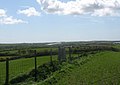
 Field edge footpath passing Graianfy Triangulation Pillar - geograph.org.uk - 5620737.jpg 4,000 × 3,000; 3.15 MB
-
 Field to the West of Llanfachraeth - geograph.org.uk - 197935.jpg 640 × 480; 97 KB
-

-
 Footbridge over the Afon Alaw (Anglesey Coastal Path) - geograph.org.uk - 5934184.jpg 5,184 × 3,456; 4.59 MB
-

-
 Gate near Bodardraeth - geograph.org.uk - 4806896.jpg 640 × 475; 80 KB
-
 Ger yr Afon Farm - geograph.org.uk - 992733.jpg 640 × 227; 22 KB
-
 Glan Gors Farm, Stryd y Facsen - geograph.org.uk - 1289025.jpg 640 × 480; 50 KB
-

-

-
 Heading west from Pen-yr-orsedd - geograph.org.uk - 6169432.jpg 6,000 × 4,000; 2.88 MB
-
 Hedge enclosed lane to Graianfryn - geograph.org.uk - 5620744.jpg 4,000 × 3,000; 3.05 MB
-
 Holland Hotel, Llanfachraeth - geograph.org.uk - 3787846.jpg 1,600 × 1,219; 274 KB
-
 Independent Welsh Chapel, Llanfachraeth (24442249423).jpg 2,193 × 1,368; 828 KB
-

-
 Llanfachraeth - geograph.org.uk - 38879.jpg 640 × 480; 57 KB
-
 Llanfachraeth - geograph.org.uk - 4806749.jpg 640 × 480; 64 KB
-
 Llanfachraeth grassland - geograph.org.uk - 3179951.jpg 3,600 × 2,205; 3.17 MB
-
 Llanfachraeth in darkness without electricity (6835498077).jpg 601 × 458; 47 KB
-

-
 Looking northeast from Pont Tan-yr-allt - geograph.org.uk - 6169420.jpg 6,000 × 4,000; 4.78 MB
-
 Looking southwest from Pont Tan-yr-allt - geograph.org.uk - 6169419.jpg 6,000 × 4,000; 4.39 MB
-
 Low water on the tidal Alaw - geograph.org.uk - 1380202.jpg 640 × 360; 32 KB
-
 Lowest bridging point on Afon Dronwy - geograph.org.uk - 1380100.jpg 640 × 480; 63 KB
-
 Maes Machraith Housing Estate - geograph.org.uk - 1363904.jpg 640 × 378; 36 KB
-
 Meander on the tidal Alaw - geograph.org.uk - 1380116.jpg 640 × 399; 46 KB
-
 Minor road junction at Graianfryn - geograph.org.uk - 992689.jpg 640 × 479; 76 KB
-

-
-
 Ordnance Survey Flush Bracket S7554 - geograph.org.uk - 5638116.jpg 4,000 × 3,000; 4.05 MB
-
 Original route of the Anglesey Coastal Path at Llanfachraeth - geograph.org.uk - 5932679.jpg 5,184 × 3,456; 6.03 MB
-
 Overgrown path on the creek causeway - geograph.org.uk - 1380250.jpg 640 × 372; 79 KB
-

-

-
 Peek-a-boo^ - geograph.org.uk - 4858768.jpg 640 × 480; 80 KB
-

-

-
 Penrhos Cottage - geograph.org.uk - 1286542.jpg 640 × 480; 59 KB
-
 Pont Aber Alaw - geograph.org.uk - 4179027.jpg 640 × 428; 70 KB
-
 Pont Aberalaw - geograph.org.uk - 4806756.jpg 640 × 480; 112 KB
-
 Pont Dronwy estate - geograph.org.uk - 1367498.jpg 640 × 480; 56 KB
-
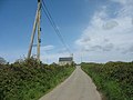
 Power lines south of Bodwigan Farm - geograph.org.uk - 1295621.jpg 640 × 482; 40 KB
-
 Premier Store, Llanfachraeth - geograph.org.uk - 4852686.jpg 640 × 480; 63 KB
-

-
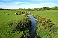
 River Alaw, near Llanfachraeth - geograph.org.uk - 4852331.jpg 640 × 480; 43 KB
-
 Road across the back of a drumlin - geograph.org.uk - 1286518.jpg 640 × 480; 75 KB
-
 Road junction east of Grianfryn Farm - geograph.org.uk - 1289048.jpg 640 × 481; 118 KB
-
 Road west towards Tan yr allt - geograph.org.uk - 1295810.jpg 640 × 480; 82 KB
-
 Rock pool near Bodardraeth - geograph.org.uk - 1366344.jpg 640 × 480; 76 KB
-
 Sewage Outfall on Traeth y Gribin - geograph.org.uk - 5942919.jpg 5,184 × 3,456; 5.58 MB
-
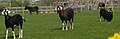
 Sheep pastures at Dronwy - geograph.org.uk - 1273140.jpg 640 × 480; 40 KB
-
 Sheep sheltering in the topmost working - geograph.org.uk - 742019.jpg 640 × 429; 108 KB
-
 St Machraeth Church, Llanfachraeth - geograph.org.uk - 6092949.jpg 1,024 × 683; 243 KB
-
 St Machraeth's Church - geograph.org.uk - 6099580.jpg 1,280 × 960; 1.35 MB
-
 Stile on Anglesey Coastal Path - geograph.org.uk - 4660825.jpg 476 × 640; 115 KB
-

-

-
 The Anglesey Coast Path - geograph.org.uk - 4806942.jpg 640 × 480; 90 KB
-
 The Anglesey Coast Path - geograph.org.uk - 4852281.jpg 640 × 480; 79 KB
-
 The Anglesey Coastal Path approaching Llanfachraeth - geograph.org.uk - 5936409.jpg 5,184 × 3,456; 4.52 MB
-
 The Anglesey Coastal Path approaching Traeth y Gribin - geograph.org.uk - 5939067.jpg 4,886 × 3,080; 4.55 MB
-
 The Anglesey Coastal Path at Traeth y Gribin - geograph.org.uk - 5942905.jpg 5,184 × 3,456; 6.19 MB
-
 The Anglesey Coastal Path at Traeth y Gribin - geograph.org.uk - 5942910.jpg 5,184 × 3,456; 5.94 MB
-
 The Anglesey Coastal Path near Bodlasan Groes - geograph.org.uk - 5939077.jpg 5,184 × 3,456; 5.66 MB
-
 The Anglesey Coastal Path near Llanfachraeth - geograph.org.uk - 5936425.jpg 5,184 × 3,456; 5.03 MB
-
 The Anglesey Coastal Path west of Llanfachraeth - geograph.org.uk - 5934180.jpg 4,184 × 2,789; 3.92 MB
-
 The Bwlch y Goriwaered sheepfold - geograph.org.uk - 726893.jpg 640 × 403; 107 KB
-
 The church at Llanfigael - geograph.org.uk - 5344624.jpg 5,067 × 3,801; 4.99 MB
-
 The Church of St Machraeth at Llanfachraeth - geograph.org.uk - 5620698.jpg 4,000 × 3,000; 3.02 MB
-

-

-

-

-
 The footbridge at Rhyd Goch - geograph.org.uk - 1290630.jpg 640 × 480; 105 KB
-
 The Holland Hotel, Llanfachraeth - geograph.org.uk - 5930861.jpg 5,184 × 3,456; 3.87 MB
-

-

-
 The Llanfwrog road at Pen-yr-orsedd - geograph.org.uk - 1289777.jpg 640 × 498; 43 KB
-

-

-

-

-
 The Old Rectory at St Machraeth, Llanfachraeth - geograph.org.uk - 6092944.jpg 1,024 × 683; 301 KB
-
 The Old Rectory, Llanfachraeth - geograph.org.uk - 6099577.jpg 1,280 × 988; 1.05 MB
-
-

-
 The path north towards Hafod-y-Fedw - geograph.org.uk - 742307.jpg 640 × 373; 76 KB
-
 The Pen-yr-orsedd road junction - geograph.org.uk - 1289766.jpg 640 × 415; 47 KB
-

-
 The refurbished Pont yr Arw Watermill - geograph.org.uk - 1364056.jpg 640 × 464; 106 KB
-
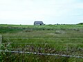
 The ruined cottage of Tywyn-gwyn - geograph.org.uk - 1365806.jpg 640 × 447; 56 KB
-

-

-
 The Tywyn-gwyn dunes - geograph.org.uk - 1365820.jpg 640 × 480; 44 KB
-
 Top Class Cow^ - geograph.org.uk - 4806888.jpg 640 × 480; 74 KB
-
 Track to Bodfardden-ddu - geograph.org.uk - 6162888.jpg 6,000 × 4,000; 3.46 MB
-
 Track to Dronwy - geograph.org.uk - 6166773.jpg 6,000 × 4,000; 3.65 MB
-

-

-
 Traeth y Gribin sands - geograph.org.uk - 1379836.jpg 640 × 480; 41 KB
-

-

-
-
-
 Ty'n y Maen Farmhouse, Stryd y Facsen - geograph.org.uk - 992841.jpg 640 × 311; 48 KB
-
 Ty'n-y-Maen Chapel (1904) - geograph.org.uk - 5344642.jpg 4,981 × 3,735; 4.87 MB
-
 Tywyn gwyn Cottage - geograph.org.uk - 4744125.jpg 640 × 452; 98 KB
-
 Tywyn-gwyn - geograph.org.uk - 5939060.jpg 5,184 × 3,456; 6.4 MB
-

-
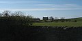
 View across farmland towards Dronwy - geograph.org.uk - 1289602.jpg 640 × 480; 57 KB
-

-

-
 View across Traeth y Gribin - geograph.org.uk - 5939091.jpg 5,184 × 3,456; 5.26 MB
-

-
 View eastwards across the causeway - geograph.org.uk - 1380257.jpg 640 × 403; 99 KB
-
 View from Bodlasan House - geograph.org.uk - 1092695.jpg 640 × 480; 53 KB
-

-
 View north towards Ty'n y Maen Chapel - geograph.org.uk - 992828.jpg 640 × 480; 88 KB
-

-

-

-

-

-

-
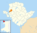 Wales Anglesey Community Llanfachraeth map.svg 512 × 451; 727 KB
-
 Wetland behind the causeway - geograph.org.uk - 1380240.jpg 640 × 414; 72 KB
-
 Wynnstay Stores, Llanfachraeth - geograph.org.uk - 3787794.jpg 1,600 × 815; 218 KB
-
 Young cattle at Pen-yr-orsedd - geograph.org.uk - 1289788.jpg 640 × 480; 45 KB
-

-
 Bridge near Llanfachraeth - geograph.org.uk - 469578.jpg 640 × 480; 58 KB


_-_geograph.org.uk_-_5934184.jpg)


.jpg)


.jpg)


_-_geograph.org.uk_-_5344642.jpg)


