Category:Llandwrog
Jump to navigation
Jump to search
village and community in Gwynedd, Wales, UK  | |||||
| Upload media | |||||
| Instance of | |||||
|---|---|---|---|---|---|
| Location | Gwynedd, Wales | ||||
| Population |
| ||||
 | |||||
English: Llandwrog ( Welsh language: meaning 'The church of Saint Twrog') is a village and community in Gwynedd, north-west Wales, most notable for the presence of the headquarters of Welsh record label Sain and the site of Caernarfon Airport. It has a population of 2,466.
Subcategories
This category has the following 5 subcategories, out of 5 total.
Media in category "Llandwrog"
The following 200 files are in this category, out of 684 total.
(previous page) (next page)-
 "Antiques Shop" Blythe Farm - geograph.org.uk - 614920.jpg 640 × 428; 123 KB
-
 A Breach in the Pebble Bar - geograph.org.uk - 250132.jpg 640 × 480; 93 KB
-
 A Dangerous T-junction - geograph.org.uk - 238286.jpg 640 × 480; 53 KB
-
 A medieval house platform - geograph.org.uk - 886993.jpg 640 × 480; 80 KB
-
 A placid reach on Afon Llifon - geograph.org.uk - 789311.jpg 640 × 480; 120 KB
-
 A rear entrance to Glynllifon Park - geograph.org.uk - 3406182.jpg 480 × 640; 158 KB
-
 A road to Rhosgadfan - geograph.org.uk - 3751994.jpg 1,024 × 768; 123 KB
-
-
 A very low tide - geograph.org.uk - 4846601.jpg 4,896 × 3,672; 6.21 MB
-
 A wartime remnant - geograph.org.uk - 4859384.jpg 4,896 × 3,672; 6.9 MB
-
 A487 approaching overhead cable - geograph.org.uk - 4704903.jpg 640 × 492; 62 KB
-
 A487 heads south towards Penygroes - geograph.org.uk - 3468176.jpg 800 × 651; 97 KB
-
 A487 south of Groeslon - geograph.org.uk - 3468158.jpg 800 × 718; 147 KB
-
 A487 south of slateworks roundabout - geograph.org.uk - 3694179.jpg 640 × 481; 43 KB
-

-
 Across the head of Foryd Bay - geograph.org.uk - 5559244.jpg 4,000 × 3,000; 2.31 MB
-
 Across Y Foryd - geograph.org.uk - 5559231.jpg 4,000 × 3,000; 2.05 MB
-

-
 Afon Carrog - geograph.org.uk - 3607507.jpg 480 × 640; 61 KB
-
 Afon Carrog - geograph.org.uk - 4877176.jpg 640 × 473; 47 KB
-
 Afon Carrog entering Y Foryd - geograph.org.uk - 6261497.jpg 1,600 × 1,067; 474 KB
-
 Afon Carrog seen from the footbridge - geograph.org.uk - 4859951.jpg 4,896 × 3,672; 5.56 MB
-
 Afon Carrog, from the footbridge - geograph.org.uk - 6261469.jpg 1,600 × 1,067; 256 KB
-
 Afon Foryd entering Y Foryd - geograph.org.uk - 6261428.jpg 2,189 × 1,460; 1.32 MB
-
 Afon Llifon - geograph.org.uk - 789025.jpg 640 × 480; 145 KB
-
 Afon Llifon, near Maes Tryfan - geograph.org.uk - 6254728.jpg 1,067 × 1,600; 733 KB
-
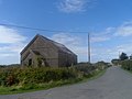
 Agricultural shed, north-east of Hafodty Wen - geograph.org.uk - 3752002.jpg 1,024 × 768; 120 KB
-
 Airfield with turbines - geograph.org.uk - 3818758.jpg 640 × 480; 102 KB
-
 Almost derelict - geograph.org.uk - 4123831.jpg 640 × 480; 450 KB
-
 Amphitheatre - geograph.org.uk - 881727.jpg 640 × 356; 86 KB
-
 An encouragement to slow down entering Groeslon - geograph.org.uk - 6255625.jpg 1,916 × 1,277; 908 KB
-
 An entrance to the estate - geograph.org.uk - 5993652.jpg 4,032 × 3,024; 2.11 MB
-
 Anglesey from Mynydd Mawr Summit - geograph.org.uk - 1833481.jpg 640 × 480; 100 KB
-
 Animal feeder near Penfforddelen Farm - geograph.org.uk - 6255620.jpg 1,600 × 1,067; 347 KB
-

-
 Back yard, Inigo Jones Slateworks - geograph.org.uk - 3406169.jpg 640 × 480; 127 KB
-
 Beach at Dinas Dinlle - geograph.org.uk - 4123762.jpg 621 × 455; 225 KB
-
 Beach, Dinas Dinlle - geograph.org.uk - 4531667.jpg 1,600 × 1,200; 475 KB
-
 Bedd Glasynys - Grave of Glasynys - geograph.org.uk - 607712.jpg 640 × 428; 88 KB
-
 Benches with a view at Carmel - geograph.org.uk - 5757225.jpg 640 × 450; 55 KB
-

-
 Bend in the embankment, west shore of Y Foryd - geograph.org.uk - 6260504.jpg 1,916 × 1,277; 1.13 MB
-
 Bodfan Standing Stone - geograph.org.uk - 1087859.jpg 640 × 483; 147 KB
-
 Boncan Dinas - geograph.org.uk - 4877412.jpg 640 × 426; 34 KB
-
 Boncan Dinas from the southeast - geograph.org.uk - 4877413.jpg 640 × 480; 55 KB
-
 Bracken-filled fields south of Trosglwyn - geograph.org.uk - 6255640.jpg 1,588 × 1,058; 780 KB
-
 Bracket fungus on a tree stump - geograph.org.uk - 3405867.jpg 480 × 640; 132 KB
-

-
 Bridge over the River Carrog - geograph.org.uk - 4877179.jpg 640 × 480; 72 KB
-
 Bryn Fferam Quarry - geograph.org.uk - 3985217.jpg 1,600 × 1,200; 654 KB
-
 Bryn Mor Beach Hotel, Dinas Dinlle - geograph.org.uk - 3825150.jpg 1,600 × 836; 187 KB
-
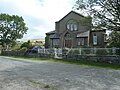
 Bryn Rodyn Chapel - geograph.org.uk - 2587052.jpg 1,500 × 1,125; 1.33 MB
-
 Bryn-castell, Abandoned Homestead - geograph.org.uk - 4662447.jpg 1,600 × 1,200; 461 KB
-
 Bryngwyn Branch slate trail, approaching Cae Haidd - geograph.org.uk - 6249580.jpg 1,946 × 1,460; 1.16 MB
-
 Bryngwyn Branch slate trail, near Bryngwyn - geograph.org.uk - 6249574.jpg 1,946 × 1,460; 1.44 MB
-
 Bryngwyn Branch slate trail, near Hafod Talog - geograph.org.uk - 6249590.jpg 1,703 × 1,277; 1.05 MB
-
 Bryngwyn farmland - geograph.org.uk - 6249558.jpg 1,703 × 1,277; 942 KB
-
 Bryngwyn tramway - geograph.org.uk - 5293786.jpg 640 × 480; 75 KB
-
 Brynrhos Chapel and Schoolroom - geograph.org.uk - 5756988.jpg 640 × 480; 64 KB
-
 Brynrhos Chapel at the eastern edge of Groeslon - geograph.org.uk - 3752019.jpg 1,024 × 768; 131 KB
-
 Building, Morfa Dinlle - geograph.org.uk - 4531672.jpg 1,600 × 1,200; 311 KB
-
 Bungalows in Bethesda - geograph.org.uk - 3202962.jpg 640 × 335; 58 KB
-

-

-
 Bus stop between Groeslon and Carmel - geograph.org.uk - 5757096.jpg 640 × 480; 75 KB
-
 Cae'r Llwyn Llandwrog - geograph.org.uk - 608549.jpg 640 × 428; 99 KB
-
 Caer Llwyn, Llandwrog - geograph.org.uk - 5846920.jpg 5,184 × 3,456; 3.54 MB
-
 Caer Llwyn, Llandwrog - geograph.org.uk - 5850705.jpg 5,184 × 3,456; 3.59 MB
-
 Caernarfon Airfield - geograph.org.uk - 809108.jpg 640 × 480; 46 KB
-
 Caernarfon Airport - geograph.org.uk - 5559246.jpg 4,000 × 3,000; 2.5 MB
-
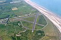 Caernarfon Airport 2003, aerial - geograph.org.uk - 3165409.jpg 640 × 423; 79 KB
-
 Caernarfon Airport and Air Museum - geograph.org.uk - 4877200.jpg 640 × 448; 40 KB
-
 Caernarfon Airport from the air - geograph.org.uk - 5164377.jpg 6,768 × 4,528; 4.45 MB
-
 Caernarfon Airport, Dinas Dinlle, Gwynedd - geograph.org.uk - 2884247.jpg 2,848 × 2,136; 1.47 MB
-
 Caernarvon Fundamental Benchmark - geograph.org.uk - 4666509.jpg 2,560 × 1,920; 2.52 MB
-
 Cafn Ceffyl Llandwrog Horse Trough - geograph.org.uk - 608536.jpg 640 × 428; 81 KB
-
 Capel Bryn 'rodyn - geograph.org.uk - 716389.jpg 640 × 381; 53 KB
-
 Capel Bwlan, Llandwrog - geograph.org.uk - 4967307.jpg 1,600 × 1,200; 413 KB
-
 Capel di-enw - An unnamed chapel - geograph.org.uk - 3607512.jpg 640 × 478; 40 KB
-
 Capel Gosen - for sale - geograph.org.uk - 5756687.jpg 640 × 480; 78 KB
-
 Capel Pisgah, Carmel - geograph.org.uk - 5757238.jpg 640 × 480; 67 KB
-
-
 Capel y Bryn, from the east - geograph.org.uk - 6249313.jpg 1,600 × 1,200; 542 KB
-
 Capel y Bryn, from the west - geograph.org.uk - 6249315.jpg 1,600 × 1,200; 591 KB
-
 Capel Y Bwlan - geograph.org.uk - 614905.jpg 640 × 428; 93 KB
-
 Carmel Crossroads - geograph.org.uk - 5757125.jpg 640 × 480; 65 KB
-
 Carmel Primary School - geograph.org.uk - 5757233.jpg 640 × 480; 79 KB
-
 Castell Caeronwy - geograph.org.uk - 4662455.jpg 1,600 × 1,200; 384 KB
-
 Cattle and barn near Groeslon - geograph.org.uk - 5756668.jpg 640 × 480; 140 KB
-
 Cattle at pasture - geograph.org.uk - 3818803.jpg 640 × 480; 104 KB
-
 Cattle grazing north-east of Caernarfon Airport - geograph.org.uk - 6261033.jpg 1,916 × 1,277; 966 KB
-

-
 Cattle grid on the road to Carmel - geograph.org.uk - 3751974.jpg 1,024 × 768; 136 KB
-
 Causeway - geograph.org.uk - 4123871.jpg 640 × 480; 262 KB
-

-

-

-
 Church of St Twrog, Llandwrog - geograph.org.uk - 5842577.jpg 3,898 × 5,467; 2.88 MB
-
 Church of St Twrog, Llandwrog - geograph.org.uk - 5842585.jpg 3,456 × 5,184; 2.36 MB
-
 Churchyard, Llandwrog - geograph.org.uk - 3826463.jpg 1,600 × 1,200; 412 KB
-
 Churchyard, Llandwrog - geograph.org.uk - 3826481.jpg 1,600 × 1,197; 337 KB
-
 Chwarel Fron Slate Quarry - geograph.org.uk - 4662442.jpg 1,200 × 1,600; 733 KB
-
 Cilgant - Crescent, Llandwrog - geograph.org.uk - 787895.jpg 640 × 480; 75 KB
-
 Cilgant Crescent, Llandwrog - geograph.org.uk - 1283238.jpg 640 × 480; 58 KB
-
 Cilgwyn tip - geograph.org.uk - 5293798.jpg 640 × 480; 76 KB
-
 Cilgwyn tramway - geograph.org.uk - 5293773.jpg 640 × 480; 72 KB
-
 Cilgwyn, Gwynedd.jpg 4,160 × 3,120; 4.57 MB
-
 Cilmyn Troed Ddu - geograph.org.uk - 6112474.jpg 473 × 640; 135 KB
-

-
 Coed y Garth north of Penygroes - geograph.org.uk - 3468240.jpg 800 × 684; 132 KB
-
 Cofeb Gwenno Hywyn Memorial - geograph.org.uk - 609499.jpg 640 × 428; 61 KB
-
 Coleg Meirion-Dwyfor - geograph.org.uk - 3208161.jpg 4,000 × 3,000; 2 MB
-
 Coleg Meirion-Dwyfor - geograph.org.uk - 3208162.jpg 4,000 × 3,000; 2.18 MB
-
 Coleg Meirion-Dwyfor - geograph.org.uk - 3208163.jpg 4,000 × 3,000; 2.07 MB
-
 Coleg Meirion-Dwyfor - geograph.org.uk - 3208164.jpg 4,000 × 3,000; 2.16 MB
-
 Coming in to land at Caernarfon Airport - geograph.org.uk - 6260461.jpg 1,600 × 1,067; 302 KB
-
 Conglomerate, Moel Tryfan - geograph.org.uk - 5264658.jpg 640 × 480; 116 KB
-

-
 Control Tower, Caernarfon Airport - geograph.org.uk - 3825191.jpg 1,600 × 1,200; 259 KB
-
 Converted chapel, north of Carmel - geograph.org.uk - 5767014.jpg 640 × 480; 79 KB
-

-

-
 Cormorants take-off from the Beach - geograph.org.uk - 250255.jpg 640 × 480; 65 KB
-

-
 Cows and calves near Groeslon - geograph.org.uk - 3405235.jpg 640 × 480; 113 KB
-
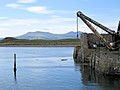 Crane at Fort Belan Dock - geograph.org.uk - 2560053.jpg 4,000 × 3,000; 1.98 MB
-
 Creek created by drainage, Y Foryd - geograph.org.uk - 6261045.jpg 1,916 × 1,277; 986 KB
-
 Crossroads near Ffrwd - geograph.org.uk - 3202887.jpg 640 × 373; 80 KB
-
 Dam of a former reservoir near Bryngwyn station (land side) - geograph.org.uk - 6249420.jpg 1,946 × 1,460; 1.09 MB
-
 Dam of a former reservoir near Bryngwyn station (water side) - geograph.org.uk - 6249424.jpg 1,946 × 1,460; 1.37 MB
-
 De Havilland Dragon Rapide at Caernarfon Airport - geograph.org.uk - 5163693.jpg 6,816 × 4,528; 4.68 MB
-

-
 Dead heather, north of Glandwr - geograph.org.uk - 6248585.jpg 1,600 × 1,200; 658 KB
-
 Derelict Building, Caernarfon Airport - geograph.org.uk - 4531677.jpg 1,600 × 1,200; 471 KB
-
 Derelict chapel, Morfa Dinlle - geograph.org.uk - 5559242.jpg 4,000 × 3,000; 2.64 MB
-
 Derelict Cottage - geograph.org.uk - 4662460.jpg 1,600 × 1,200; 614 KB
-
 Dinas Beach - geograph.org.uk - 6027091.jpg 2,000 × 1,358; 1.53 MB
-
 Dinas Dinlle - geograph.org.uk - 3253636.jpg 1,600 × 1,200; 509 KB
-
 Dinas Dinlle - geograph.org.uk - 3260007.jpg 4,000 × 3,000; 5.13 MB
-
 Dinas Dinlle - geograph.org.uk - 5559175.jpg 4,000 × 2,141; 1.28 MB
-

-
 Dinas Dinlle from the hill fort - geograph.org.uk - 3488241.jpg 640 × 462; 61 KB
-
 Disused airport buildings - geograph.org.uk - 4123806.jpg 640 × 480; 266 KB
-
 Disused Building, Cae Haidd - geograph.org.uk - 4602579.jpg 1,600 × 1,200; 708 KB
-
 Disused Chapel, Morfa Dinlle - geograph.org.uk - 4531681.jpg 1,600 × 1,200; 424 KB
-

-
 Dogs on the shingle berm at Dinas Dinlle - geograph.org.uk - 4888225.jpg 1,554 × 506; 178 KB
-
 Drain along the sea wall, east of Caernarfon Airport - geograph.org.uk - 6260527.jpg 1,916 × 1,277; 1.13 MB
-
 Driveway - geograph.org.uk - 4123882.jpg 640 × 480; 326 KB
-
 Driveway into Plas Newydd - geograph.org.uk - 4168564.jpg 640 × 427; 54 KB
-
-
 Eisteddfod yr Urdd 2012 - geograph.org.uk - 2937212.jpg 4,000 × 3,000; 1.97 MB
-
 Eisteddfod yr Urdd 2012 - geograph.org.uk - 2937217.jpg 4,000 × 3,000; 2.53 MB
-
 Eisteddfod yr Urdd 2012 - geograph.org.uk - 2937220.jpg 4,000 × 3,000; 2.02 MB
-
 Elegant waves - geograph.org.uk - 3165059.jpg 640 × 480; 88 KB
-
 Embankment on the Bryngwyn Branch slate trail - geograph.org.uk - 6249597.jpg 1,946 × 1,460; 1.52 MB
-
 End of the public right of way - geograph.org.uk - 4859390.jpg 4,896 × 3,672; 6.36 MB
-
 Englyn - Poem - geograph.org.uk - 608317.jpg 640 × 428; 59 KB
-

-
 Entering Llandwrog - geograph.org.uk - 5842565.jpg 5,184 × 3,456; 3.17 MB
-
 Entering Llandwrog - geograph.org.uk - 5852600.jpg 5,184 × 3,456; 3.36 MB
-

-

-
 Entrance to Cae Haidd - geograph.org.uk - 3751964.jpg 1,024 × 768; 128 KB
-
 Entrance to Dinas Dinlle - geograph.org.uk - 3251162.jpg 640 × 432; 38 KB
-

-

-
 Exposed pebbles at low tide - geograph.org.uk - 4845668.jpg 4,896 × 3,672; 5.36 MB
-
 Express Motors - geograph.org.uk - 5264671.jpg 640 × 480; 65 KB
-
 Farm road to Lleiniau Farm - geograph.org.uk - 787681.jpg 640 × 480; 68 KB
-

-
 Farmhouse near Groeslon - geograph.org.uk - 3405817.jpg 640 × 480; 91 KB
-
 Farmland at Groeslon - geograph.org.uk - 5757092.jpg 640 × 480; 87 KB
-
 Farmland below the Bryngwyn Branch slate trail - geograph.org.uk - 6249586.jpg 1,946 × 1,460; 1.32 MB
-
 Farmland near Pen-y-Bythod - geograph.org.uk - 5993638.jpg 4,032 × 3,024; 2.24 MB
-
 Farmland north-east of Penfforddelen Farm - geograph.org.uk - 6255617.jpg 1,916 × 1,277; 1.07 MB
-
 Farmland south of Bethesda Bach - geograph.org.uk - 1802760.jpg 1,024 × 672; 85 KB
-
 Farmland south-east of Penfforddelen Farm - geograph.org.uk - 6255614.jpg 1,845 × 1,230; 760 KB
-

-
 Fferm Maes Mawr from the Beach - geograph.org.uk - 250514.jpg 640 × 419; 63 KB
-
 Field and sheep at Llandwrog - geograph.org.uk - 6132137.jpg 800 × 440; 91 KB
-
 Field east of the A487 north of Groeslon - geograph.org.uk - 5755679.jpg 640 × 480; 105 KB
-
 Field near Bethesda Bach - geograph.org.uk - 5993655.jpg 4,032 × 3,024; 2.93 MB
-
 Fields and sheep near Dinas Dinlle - geograph.org.uk - 6132147.jpg 800 × 536; 99 KB
-
 Fields between Cae Uchaf and Trosglwyn - geograph.org.uk - 6255643.jpg 1,867 × 1,244; 742 KB
-
 Fields near Glandwr - geograph.org.uk - 6249305.jpg 1,600 × 1,200; 607 KB
-
 Fields near Warren Farm - geograph.org.uk - 6261080.jpg 1,916 × 1,277; 1 MB
-
 Fields outside Llandwrog - geograph.org.uk - 5993618.jpg 4,032 × 3,024; 2.64 MB
-
 Flooded fields at Warren Farm - geograph.org.uk - 3818788.jpg 640 × 480; 100 KB
-
 Flooded pit at Braich slate quarry - geograph.org.uk - 5558054.jpg 640 × 480; 82 KB
-
 Flush Bracket G2750 on Tafarn Pennionyn, Groeslon - geograph.org.uk - 3082716.jpg 3,240 × 4,320; 2.83 MB
-
 Footbridge on the Afon Carrog - geograph.org.uk - 4859446.jpg 4,896 × 3,672; 6.9 MB
-
 Footbridge over Afon Carrog - geograph.org.uk - 6261463.jpg 1,600 × 1,067; 436 KB
-

-
 Footpath at Carmel - geograph.org.uk - 5757121.jpg 640 × 480; 72 KB
-
 Footpath junction, south-east of Dafarn Dywarch - geograph.org.uk - 6248579.jpg 1,600 × 1,200; 715 KB
-

-
 Footpath South Of Cefnen - geograph.org.uk - 5391205.jpg 1,600 × 1,200; 803 KB
-
 Footpath Starts Well - geograph.org.uk - 4666526.jpg 2,560 × 1,920; 2.47 MB
-
 Forest track junction at Bryn Cocsydd - geograph.org.uk - 789420.jpg 640 × 480; 135 KB


_-_geograph.org.uk_-_6249420.jpg)
_-_geograph.org.uk_-_6249424.jpg)


_-_geograph.org.uk_-_150952.jpg)


