Category:Llanddeiniolen (community)
Jump to navigation
Jump to search
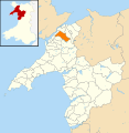
English: Llanddeiniolen community (civil parish), including the villages of Bethel, Deiniolen and the northern half of Llyn (Lake) Padarn.
Subcategories
This category has the following 9 subcategories, out of 9 total.
Media in category "Llanddeiniolen (community)"
The following 148 files are in this category, out of 148 total.
-
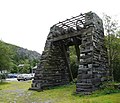
A Blondin Conveyance at Vivian Quarry - geograph.org.uk - 1769482.jpg 1,024 × 768; 308 KB
-
A terrace of cottages at Seion - geograph.org.uk - 362450.jpg 640 × 275; 29 KB
-
Afon Fachwen - geograph.org.uk - 1768586.jpg 1,024 × 768; 309 KB
-
Approaching the top of the hill - geograph.org.uk - 1768625.jpg 1,024 × 768; 359 KB
-
Arwel and the Glasgoed road entrance - geograph.org.uk - 281354.jpg 640 × 351; 55 KB
-
Bedw Argoed track near Cae Mabon - geograph.org.uk - 1768580.jpg 1,024 × 768; 333 KB
-
Blast Warnings on the approach to Vivian Quarry - geograph.org.uk - 1769520.jpg 1,024 × 768; 165 KB
-
Boarded-up Building, in Deiniolen. - geograph.org.uk - 1571613.jpg 640 × 426; 50 KB
-
Bryn Ffynnon cottage - geograph.org.uk - 1768577.jpg 1,024 × 768; 233 KB
-
Caernarvonshire Clawdd - geograph.org.uk - 1277203.jpg 640 × 480; 137 KB
-
Carfan looking west - geograph.org.uk - 966196.jpg 640 × 480; 65 KB
-
Close-up of the Upper Penrhydd 'Caban' - geograph.org.uk - 293279.jpg 640 × 476; 114 KB
-
Cwm Marchlyn Mawr - geograph.org.uk - 427708.jpg 640 × 299; 51 KB
-
Cwt Ambiwlans Chwaral - Quarry Ambulance Station - geograph.org.uk - 1757243.jpg 1,024 × 768; 352 KB
-
Dinorwig Quarry Hospital from the mortuary door - geograph.org.uk - 1769023.jpg 3,264 × 2,448; 1.53 MB
-
Dinorwig Quarry Hospital from the west - geograph.org.uk - 1769072.jpg 1,024 × 768; 242 KB
-
East Wing of Glasgoed Hall - geograph.org.uk - 280764.jpg 640 × 480; 129 KB
-
Efail Y Gof - Blacksmith Forges - geograph.org.uk - 1036678.jpg 640 × 477; 100 KB
-
Fields near Erw Fawr - geograph.org.uk - 807803.jpg 640 × 480; 69 KB
-
Fields south of the B4366 - geograph.org.uk - 1279563.jpg 640 × 413; 24 KB
-
Fine oaks and a horse at Carfan - geograph.org.uk - 966199.jpg 640 × 480; 114 KB
-
Footpath to Ynys Farm - geograph.org.uk - 1277214.jpg 480 × 640; 123 KB
-
Gallt Fachwen - geograph.org.uk - 1768460.jpg 1,024 × 768; 331 KB
-
Gallt Fachwen below Pen-y-clip - geograph.org.uk - 1768486.jpg 1,024 × 768; 335 KB
-
Grass for silage - geograph.org.uk - 1277197.jpg 640 × 480; 86 KB
-
Grazing land north of the A4244 - geograph.org.uk - 825240.jpg 640 × 480; 59 KB
-
Grazing sheep on a drumlin - geograph.org.uk - 968564.jpg 640 × 480; 53 KB
-
Groeslon Ty-Mawr Crossroads - geograph.org.uk - 825236.jpg 640 × 363; 39 KB
-
Hill above Ty-Mawr - geograph.org.uk - 815098.jpg 640 × 317; 31 KB
-
Llanddeiniolen, UK - panoramio (1).jpg 5,184 × 3,456; 4.62 MB
-
Llanddeiniolen, UK - panoramio (10).jpg 8,779 × 3,156; 4.04 MB
-
Llanddeiniolen, UK - panoramio (11).jpg 8,974 × 3,585; 7.02 MB
-
Llanddeiniolen, UK - panoramio (12).jpg 6,813 × 3,472; 6.29 MB
-
Llanddeiniolen, UK - panoramio (13).jpg 5,184 × 3,456; 5.61 MB
-
Llanddeiniolen, UK - panoramio (14).jpg 5,184 × 3,456; 6.59 MB
-
Llanddeiniolen, UK - panoramio (15).jpg 5,913 × 3,229; 3.27 MB
-
Llanddeiniolen, UK - panoramio (16).jpg 9,233 × 2,895; 4.26 MB
-
Llanddeiniolen, UK - panoramio (17).jpg 6,326 × 2,504; 3.54 MB
-
Llanddeiniolen, UK - panoramio (18).jpg 5,537 × 3,103; 4.9 MB
-
Llanddeiniolen, UK - panoramio (19).jpg 10,811 × 3,202; 9.31 MB
-
Llanddeiniolen, UK - panoramio (2).jpg 5,184 × 3,456; 4.31 MB
-
Llanddeiniolen, UK - panoramio (20).jpg 5,184 × 3,456; 4.57 MB
-
Llanddeiniolen, UK - panoramio (21).jpg 9,190 × 3,892; 5.4 MB
-
Llanddeiniolen, UK - panoramio (22).jpg 8,462 × 3,765; 8.05 MB
-
Llanddeiniolen, UK - panoramio (23).jpg 5,184 × 3,456; 4.08 MB
-
Llanddeiniolen, UK - panoramio (24).jpg 7,771 × 3,555; 6.76 MB
-
Llanddeiniolen, UK - panoramio (25).jpg 5,184 × 3,456; 3.39 MB
-
Llanddeiniolen, UK - panoramio (26).jpg 7,374 × 3,640; 5.16 MB
-
Llanddeiniolen, UK - panoramio (28).jpg 5,184 × 3,456; 3.58 MB
-
Llanddeiniolen, UK - panoramio (29).jpg 7,508 × 3,324; 4.85 MB
-
Llanddeiniolen, UK - panoramio (3).jpg 5,729 × 3,446; 4.24 MB
-
Llanddeiniolen, UK - panoramio (30).jpg 14,051 × 4,426; 9.51 MB
-
Llanddeiniolen, UK - panoramio (4).jpg 5,666 × 3,326; 3.9 MB
-
Llanddeiniolen, UK - panoramio (5).jpg 6,125 × 4,132; 5.2 MB
-
Llanddeiniolen, UK - panoramio (6).jpg 5,184 × 3,456; 3.33 MB
-
Llanddeiniolen, UK - panoramio (7).jpg 5,184 × 3,456; 2.8 MB
-
Llanddeiniolen, UK - panoramio (8).jpg 5,184 × 3,456; 4.04 MB
-
Llanddeiniolen, UK - panoramio (9).jpg 8,493 × 3,464; 7.49 MB
-
Llanddeiniolen, UK - panoramio - IIya Kuzhekin (1).jpg 4,000 × 3,000; 3.65 MB
-
Llanddeiniolen, UK - panoramio - IIya Kuzhekin (10).jpg 4,000 × 2,250; 2.2 MB
-
Llanddeiniolen, UK - panoramio - IIya Kuzhekin (11).jpg 4,000 × 2,250; 1.92 MB
-
Llanddeiniolen, UK - panoramio - IIya Kuzhekin (12).jpg 4,000 × 3,000; 2.91 MB
-
Llanddeiniolen, UK - panoramio - IIya Kuzhekin (13).jpg 4,000 × 3,000; 2.34 MB
-
Llanddeiniolen, UK - panoramio - IIya Kuzhekin (14).jpg 4,000 × 2,250; 2.73 MB
-
Llanddeiniolen, UK - panoramio - IIya Kuzhekin (15).jpg 4,000 × 2,250; 2.54 MB
-
Llanddeiniolen, UK - panoramio - IIya Kuzhekin (16).jpg 4,000 × 3,000; 3.6 MB
-
Llanddeiniolen, UK - panoramio - IIya Kuzhekin (2).jpg 4,000 × 3,000; 2.11 MB
-
Llanddeiniolen, UK - panoramio - IIya Kuzhekin (3).jpg 3,000 × 4,000; 3.31 MB
-
Llanddeiniolen, UK - panoramio - IIya Kuzhekin (4).jpg 4,000 × 3,000; 2.81 MB
-
Llanddeiniolen, UK - panoramio - IIya Kuzhekin (6).jpg 4,000 × 2,250; 3 MB
-
Llanddeiniolen, UK - panoramio - IIya Kuzhekin (7).jpg 4,000 × 2,250; 2.49 MB
-
Llanddeiniolen, UK - panoramio - IIya Kuzhekin (8).jpg 4,000 × 3,000; 2.6 MB
-
Llanddeiniolen, UK - panoramio - IIya Kuzhekin (9).jpg 4,000 × 3,000; 4.3 MB
-
Llanddeiniolen, UK - panoramio - IIya Kuzhekin.jpg 4,000 × 3,000; 3.68 MB
-
Llanddeiniolen, UK - panoramio.jpg 4,000 × 3,000; 1.94 MB
-
Llyn Marchlyn Mawr - geograph.org.uk - 543177.jpg 640 × 426; 139 KB
-
Llyn Peris from the Llwybr Main path - geograph.org.uk - 1428922.jpg 640 × 480; 122 KB
-
Lon Glai - geograph.org.uk - 1279223.jpg 640 × 480; 59 KB
-
Lon Stabla Lane after the deluge - geograph.org.uk - 1591659.jpg 640 × 480; 110 KB
-
Looking back towards Deiniolen - geograph.org.uk - 809221.jpg 640 × 480; 96 KB
-
Muddy pool at the bottom of Faenol Quarry - geograph.org.uk - 1768567.jpg 1,024 × 715; 316 KB
-
New Age dwellings in the disused Faenol Quarry - geograph.org.uk - 1768539.jpg 1,024 × 841; 418 KB
-
No spanner in the works here... - geograph.org.uk - 1274926.jpg 640 × 480; 105 KB
-
Path through Coed Chwaral woodland - geograph.org.uk - 1768608.jpg 1,024 × 710; 311 KB
-
Pen-y-clip cottage in view - geograph.org.uk - 1768490.jpg 1,024 × 768; 239 KB
-
Pen-y-clip Cottage, Fachwen - geograph.org.uk - 1757277.jpg 1,024 × 768; 373 KB
-
Power lines at Glanrhyd - geograph.org.uk - 825295.jpg 640 × 480; 65 KB
-
Rhosyrwylfa and the road to Seion - geograph.org.uk - 809812.jpg 640 × 290; 38 KB
-
Rhyd-y-galen Farmhouse - geograph.org.uk - 740265.jpg 640 × 388; 69 KB
-
Rubbish run over bridge at Faenol Quarry - geograph.org.uk - 1768526.jpg 1,024 × 768; 340 KB
-
Ruined buildings at the disused Faenol Quarry - geograph.org.uk - 1768523.jpg 1,024 × 785; 382 KB
-
Sharp bend in the twisty Fachwen road - geograph.org.uk - 1768473.jpg 1,024 × 768; 311 KB
-
Slate fence - geograph.org.uk - 1277218.jpg 640 × 480; 163 KB
-
Slate Quarry - geograph.org.uk - 1287555.jpg 640 × 480; 92 KB
-
Standing stone near Llanrug - geograph.org.uk - 1279221.jpg 460 × 640; 84 KB
-
Steep section of the woodland path - geograph.org.uk - 1768636.jpg 973 × 1,024; 453 KB
-
Tai Cae Rhos - geograph.org.uk - 121266.jpg 640 × 480; 49 KB
-
Tai Cae Rhos - geograph.org.uk - 360343.jpg 640 × 480; 66 KB
-
Tai Cae Rhos - geograph.org.uk - 362456.jpg 640 × 357; 37 KB
-
Tai Gweledfa, Deiniolen - geograph.org.uk - 808516.jpg 480 × 640; 51 KB
-
Tandderwen - geograph.org.uk - 1277178.jpg 640 × 480; 53 KB
-
Tawelfa, Glasgoed - geograph.org.uk - 295555.jpg 640 × 480; 88 KB
-
Telephone box - geograph.org.uk - 1036913.jpg 640 × 480; 115 KB
-
The backwall of Faenol Quarry - geograph.org.uk - 1768572.jpg 1,024 × 768; 361 KB
-
The Bedw Argoed track at Faenol Quarry - geograph.org.uk - 1768533.jpg 1,024 × 840; 398 KB
-
The broad open summit of the path - geograph.org.uk - 1768644.jpg 1,024 × 768; 371 KB
-
The Dinorwig Quarry Mortuary - geograph.org.uk - 1769042.jpg 1,024 × 768; 243 KB
-
The former Capel Fachwen (MC) - geograph.org.uk - 1757285.jpg 1,024 × 768; 241 KB
-
The former Ty Capel Glasgoed - geograph.org.uk - 281049.jpg 640 × 480; 115 KB
-
The hamlet of Carfan, Pentir - geograph.org.uk - 966194.jpg 640 × 480; 51 KB
-
Track to Llwyn Bedw - geograph.org.uk - 1279227.jpg 640 × 480; 63 KB
-
Ty Mawr farmhouse - geograph.org.uk - 1279568.jpg 640 × 351; 20 KB
-
Ty'n Clwt, Glasgoed - geograph.org.uk - 281527.jpg 640 × 480; 110 KB
-
Units on the south side of Pentre Newydd - geograph.org.uk - 1428840.jpg 640 × 480; 104 KB
-
View back along the path - geograph.org.uk - 1768631.jpg 1,024 × 919; 354 KB
-
View from Ty-mawr - geograph.org.uk - 1333044.jpg 640 × 480; 248 KB
-
View to Llyn Padarn from Gallt-y-Foel - geograph.org.uk - 809224.jpg 640 × 480; 120 KB
-
Wales Gwynedd Community Llanddeiniolen map.svg 512 × 524; 983 KB
-
Winding structure - geograph.org.uk - 1405989.jpg 640 × 547; 357 KB
-
Wooded slope above Llyn Padarn - geograph.org.uk - 1768613.jpg 1,024 × 768; 373 KB
-
Wooded slope above the ruined Bedw Argoed mill - geograph.org.uk - 1768591.jpg 768 × 1,024; 366 KB
-
Woodland Path above Pentre Newydd - geograph.org.uk - 1428851.jpg 640 × 480; 156 KB
-
Woodland south of Allt Ddu - geograph.org.uk - 1428849.jpg 640 × 480; 151 KB
-
The West Wing of Glasgoed Hall - geograph.org.uk - 280770.jpg 640 × 480; 98 KB


