Category:Little Cacapon Mountain
Jump to navigation
Jump to search
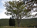
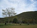
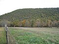
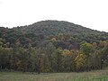
English: Little Cacapon Mountain is a mountain ridge of the Ridge-and-valley Appalachians in Hampshire County, West Virginia, United States. The mountain takes its name from the Little Cacapon River, a Potomac River tributary that lies on its western flanks. Little Cacapon Mountain reaches its highest point of 1,575 feet (480 m) in the vicinity of Barnes Mill. It spans from the Frenchburg area, where it is joined by Chestnut Oak Ridge, to the Slanesville Pike where Crooked Run forms a gap between Little Cacapon Mountain and Queens Ridge near Higginsville.
| Object location | | View all coordinates using: OpenStreetMap |
|---|
mountain in West Virginia, United States  | |||||
| Upload media | |||||
| Instance of | |||||
|---|---|---|---|---|---|
| Part of |
| ||||
| Location | West Virginia | ||||
| Elevation above sea level |
| ||||
 | |||||
Media in category "Little Cacapon Mountain"
The following 6 files are in this category, out of 6 total.
-
 Ginevan Cemetery Little Cacapon WV 2008 10 13 03.jpg 3,264 × 2,448; 2.94 MB
-
 Ginevan Cemetery Little Cacapon WV 2008 10 13 04.jpg 3,264 × 2,448; 3.31 MB
-
 Ginevan Cemetery Little Cacapon WV 2008 10 13 05.jpg 3,264 × 2,448; 2.23 MB
-
 Little Cacapon Mountain Little Cacapon WV 2008 10 13 01.jpg 3,264 × 2,448; 2.2 MB
-
 Little Cacapon Mountain Little Cacapon WV 2008 10 13 02.jpg 3,264 × 2,448; 2.9 MB
-
 Little Cacapon Mountain Little Cacapon WV 2008 10 13 03.jpg 3,264 × 2,448; 1.93 MB


